

GRIP HIGH ALTITUDE IMAGING WIND AND RAIN AIRBORNE PROFILER (HIWRAP) V1
Access & Use Information
Downloads & Resources
-
Google Scholar search resultsHTML
Search results for publications that cite this dataset by its DOI.
-
Download this datasetHTML
Files may be downloaded directly to your workstation from this link
-
Get a related visualizationGIF
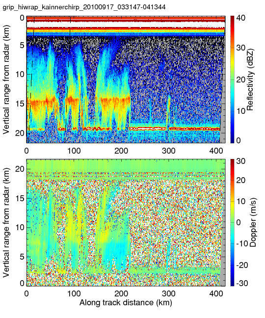
Sample browse image
-
View documentation related to this datasetHTML
The guide document contains detailed information about the dataset
-
View the primary investigator's documentation...HTML
High-altitude Imaging Wind and Rain Airborne Profiler (HIWRAP)
-
View this dataset's publicationsHTML
Velocity-Azimuth Display Analysis of Doppler Velocity for HIWRAP; Journal of...
-
View this dataset's publicationsHTML
Ensemble Kalman Filter Assimilation of HIWRAP Observations of Hurricane Karl...
-
View this dataset's publicationsHTML
Wind Retrieval Algorithms for the IWRAP and HIWRAP Airborne Doppler Radars...
-
View the documentation for this dataset's algorithmsHTML
The NASA High-Altitude Imaging Wind and Rain Airborne Profiler; IEEE...
-
The dataset's project home pageHTML
The home page for the project or program which sponsored the dataset
-
View a micro article on this datasetHTML
Hurricane Micro Article
-
Get a related visualizationHTML
N/A
-
View documentation related to this datasetHTML
Instructions for citing GHRC data
-
Landing PageLanding Page
Dates
| Metadata Created Date | December 1, 2022 |
|---|---|
| Metadata Updated Date | December 6, 2023 |
Metadata Source
- Data.json Data.json Metadata
Harvested from NASA Data.json
Graphic Preview
Additional Metadata
| Resource Type | Dataset |
|---|---|
| Metadata Created Date | December 1, 2022 |
| Metadata Updated Date | December 6, 2023 |
| Publisher | NASA/MSFC/GHRC |
| Maintainer | |
| Identifier | C1979853297-GHRC_DAAC |
| Data First Published | 2012-05-02 |
| Language | en-US |
| Data Last Modified | 2022-05-24 |
| Category | GRIP (HURRICANE), geospatial |
| Public Access Level | public |
| Bureau Code | 026:00 |
| Metadata Context | https://project-open-data.cio.gov/v1.1/schema/catalog.jsonld |
| Metadata Catalog ID | https://data.nasa.gov/data.json |
| Schema Version | https://project-open-data.cio.gov/v1.1/schema |
| Catalog Describedby | https://project-open-data.cio.gov/v1.1/schema/catalog.json |
| Citation | Heymsfield, Gerald M and Lin Tian.2012. GRIP HIGH ALTITUDE IMAGING WIND AND RAIN AIRBORNE PROFILER (HIWRAP) indicate subset used. Dataset available online from the NASA Global Hydrometeorology Resource Center DAAC, Huntsville, Alabama, U.S.A. DOI: http://dx.doi.org/10.5067/GRIP/HIWRAP/DATA101 |
| Graphic Preview Description | N/A |
| Graphic Preview File | https://ghrc.nsstc.nasa.gov/pub/fieldCampaigns/grip/HIWRAP/browse/ |
| Harvest Object Id | 0faf0db0-812f-4821-93df-a487185c7463 |
| Harvest Source Id | 58f92550-7a01-4f00-b1b2-8dc953bd598f |
| Harvest Source Title | NASA Data.json |
| Homepage URL | https://doi.org/10.5067/GRIP/HIWRAP/DATA101 |
| Metadata Type | geospatial |
| Old Spatial | -96.0111 12.0907 -77.1902 26.4101 |
| Program Code | 026:001 |
| Source Datajson Identifier | True |
| Source Hash | 5b8983c003f61b54bc02a36d8185c56e4004cea1176fcd96722519a09e1a305c |
| Source Schema Version | 1.1 |
| Spatial | |
| Temporal | 2010-09-16T17:46:57Z/2010-09-24T09:05:31Z |
Didn't find what you're looking for? Suggest a dataset here.