Delta-X: ANUGA Hydrodynamic Outputs, Atchafalaya and Terrebonne, MRD, USA
Access & Use Information
Downloads & Resources
-
Google Scholar search resultsHTML
Search results for publications that cite this dataset by its DOI.
-
Download this datasetHTML
This link allows direct data access via Earthdata login
-
View documentation related to this datasetHTML
ORNL DAAC Data Set Documentation
-
This dataset's landing pageHTML
Data set Landing Page DOI URL
-
Use OPeNDAP to access the dataset's dataHTML
USE SERVICE API
-
View documentation related to this datasetPDF
Delta-X: ANUGA Hydrodynamic Outputs, Atchafalaya and Terrebonne, MRD, USA:...
-
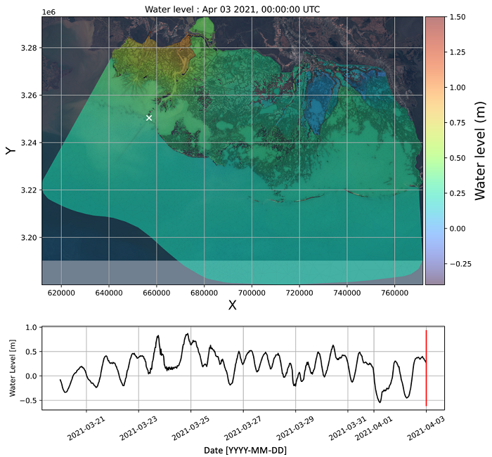
Get a related visualizationPNG
Figure 1: Snapshot of the water surface elevation in the model domain.
-
The dataset's project home pageHTML
Delta-X Project Site
-
Landing PageLanding Page
Dates
| Metadata Created Date | June 18, 2024 |
|---|---|
| Metadata Updated Date | June 18, 2024 |
Metadata Source
- Data.json Data.json Metadata
Harvested from NASA Data.json
Graphic Preview

Additional Metadata
| Resource Type | Dataset |
|---|---|
| Metadata Created Date | June 18, 2024 |
| Metadata Updated Date | June 18, 2024 |
| Publisher | ORNL_DAAC |
| Maintainer | |
| Identifier | C3091322507-ORNL_CLOUD |
| Data First Published | 2024-06-12 |
| Language | en-US |
| Data Last Modified | 2024-06-13 |
| Category | Delta-X, geospatial |
| Public Access Level | public |
| Bureau Code | 026:00 |
| Metadata Context | https://project-open-data.cio.gov/v1.1/schema/catalog.jsonld |
| Metadata Catalog ID | https://data.nasa.gov/data.json |
| Schema Version | https://project-open-data.cio.gov/v1.1/schema |
| Catalog Describedby | https://project-open-data.cio.gov/v1.1/schema/catalog.json |
| Citation | Soloy, A., A.L. Christensen, D.J. Jensen, M.W. Denbina, K.A. Wright, P. Passalacqua, and M. Simard. 2024. Delta-X: ANUGA Hydrodynamic Outputs, Atchafalaya and Terrebonne, MRD, USA. ORNL DAAC, Oak Ridge, Tennessee, USA. https://doi.org/10.3334/ORNLDAAC/2310 |
| Graphic Preview Description | Figure 1: Snapshot of the water surface elevation in the model domain. |
| Graphic Preview File | https://daac.ornl.gov/DELTAX/guides/DeltaX_ANUGA_Hydrodynamics_MRD_Fig1.png |
| Harvest Object Id | 1a1cb71a-512b-4353-864c-b061b0501098 |
| Harvest Source Id | 58f92550-7a01-4f00-b1b2-8dc953bd598f |
| Harvest Source Title | NASA Data.json |
| Homepage URL | https://doi.org/10.3334/ORNLDAAC/2310 |
| Metadata Type | geospatial |
| Old Spatial | -91.86 28.71 -90.18 29.96 |
| Program Code | 026:001 |
| Source Datajson Identifier | True |
| Source Hash | e5daa3fab7fe73e04174b885341eb06d23032c782a9c35b9707750a519067d60 |
| Source Schema Version | 1.1 |
| Spatial | |
| Temporal | 2021-03-20T00:00:00Z/2021-04-02T23:59:59Z |
Didn't find what you're looking for? Suggest a dataset here.

