ABoVE: AVIRIS-NG Imaging Spectroscopy for Alaska, Canada, and Iceland, 2017-2022, V3
Access & Use Information
Downloads & Resources
-
Google Scholar search resultsHTML
Search results for publications that cite this dataset by its DOI.
-
Download this datasetHTML
This link allows direct data access via Earthdata login
-
View documentation related to this datasetHTML
ORNL DAAC Data Set Documentation
-
This dataset's landing pageHTML
Data set Landing Page DOI URL
-
View documentation related to this datasetPDF
ABoVE: AVIRIS-NG Imaging Spectroscopy for Alaska, Canada, and Iceland,...
-
Get a related visualizationJPEG
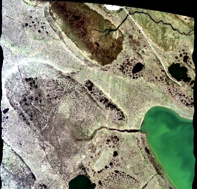
A portion of the quicklook image from flight line ang20170714t212855 over...
-
The dataset's project home pageHTML
ABoVE project site
-
Landing PageLanding Page
Dates
| Metadata Created Date | October 8, 2024 |
|---|---|
| Metadata Updated Date | October 8, 2024 |
Metadata Source
- Data.json Data.json Metadata
Harvested from NASA Data.json
Graphic Preview

Additional Metadata
| Resource Type | Dataset |
|---|---|
| Metadata Created Date | October 8, 2024 |
| Metadata Updated Date | October 8, 2024 |
| Publisher | ORNL_DAAC |
| Maintainer | |
| Identifier | C3253178409-ORNL_CLOUD |
| Data First Published | 2024-09-27 |
| Language | en-US |
| Data Last Modified | 2024-10-04 |
| Category | ABoVE, geospatial |
| Public Access Level | public |
| Bureau Code | 026:00 |
| Metadata Context | https://project-open-data.cio.gov/v1.1/schema/catalog.jsonld |
| Metadata Catalog ID | https://data.nasa.gov/data.json |
| Schema Version | https://project-open-data.cio.gov/v1.1/schema |
| Catalog Describedby | https://project-open-data.cio.gov/v1.1/schema/catalog.json |
| Citation | Miller, C.E., R.O. Green, D.R. Thompson, A.K. Thorpe, M. Eastwood, I.B. Mccubbin, W. Olson-Duvall, M. Bernas, C.M. Sarture, S. Nolte, L.M. Rios, M.A. Hernandez, B.D. Bue, and S.R. Lundeen. 2024. ABoVE: AVIRIS-NG Imaging Spectroscopy for Alaska, Canada, and Iceland, 2017-2022, V3. ORNL DAAC, Oak Ridge, Tennessee, USA. https://doi.org/10.3334/ORNLDAAC/2362 |
| Graphic Preview Description | A portion of the quicklook image from flight line ang20170714t212855 over Barrow, Alaska on July 14, 2017. Two sites (AB_B10_L001_FL175_PipelineLake and AB_B10_L003_FL175_PipelineLake) of interest to the ABoVE project are visible. Flight altitude was approximately 5,400 m with very thin cirrus cloud cover. |
| Graphic Preview File | https://daac.ornl.gov/ABOVE/guides/ABoVE_Airborne_AVIRIS_NG_V3_Fig1.jpg |
| Harvest Object Id | 549f08b2-88d5-45e7-8643-f58a8b259e1b |
| Harvest Source Id | 58f92550-7a01-4f00-b1b2-8dc953bd598f |
| Harvest Source Title | NASA Data.json |
| Homepage URL | https://doi.org/10.3334/ORNLDAAC/2362 |
| Metadata Type | geospatial |
| Old Spatial | -166.65 52.16 28.22 71.38 |
| Program Code | 026:001 |
| Source Datajson Identifier | True |
| Source Hash | 81760bd2af54fd5a049e374cf1e3c7f14bce19b8fda734cbe863535b2d846f91 |
| Source Schema Version | 1.1 |
| Spatial | |
| Temporal | 2017-06-24T00:00:00Z/2022-08-19T23:59:59Z |
Didn't find what you're looking for? Suggest a dataset here.

