

12 datasets found
-
Federal
Tularosa Basin Play Fairway Analysis: Modeled MT Resistivity Data for the McGregor Range, New Mexico
Department of Energy —
This is the inversion resistivity data from a magnetotelluric survey done as part of Phase 2 Tularosa Basin, New Mexico, geothermal play fairway analysis. The data... -
Federal
Tularosa Basin Play Fairway Analysis Data and Models
Department of Energy —
This submission includes raster datasets for each layer of evidence used for weights of evidence analysis as well as the deterministic play fairway analysis (PFA).... -
Federal
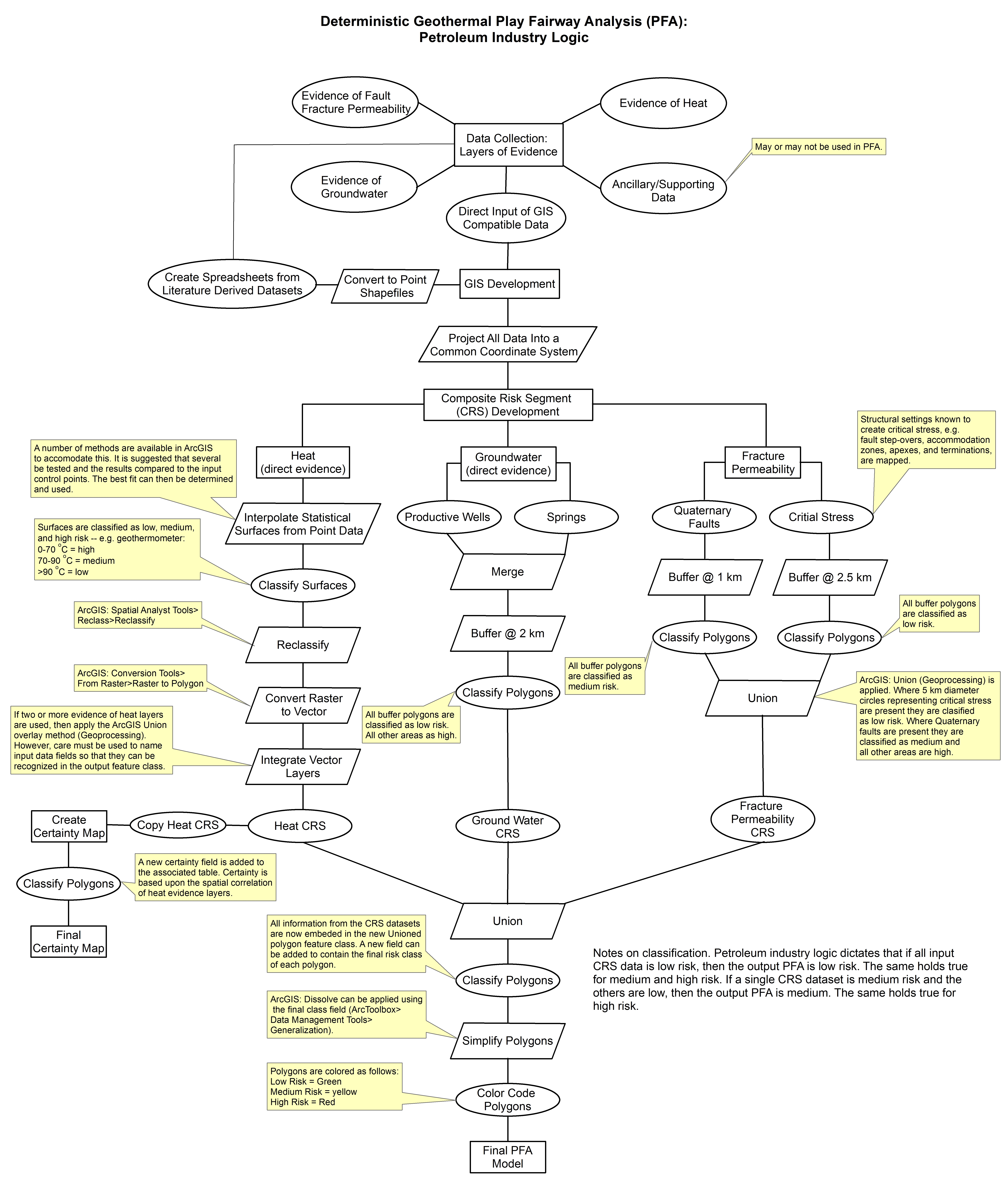
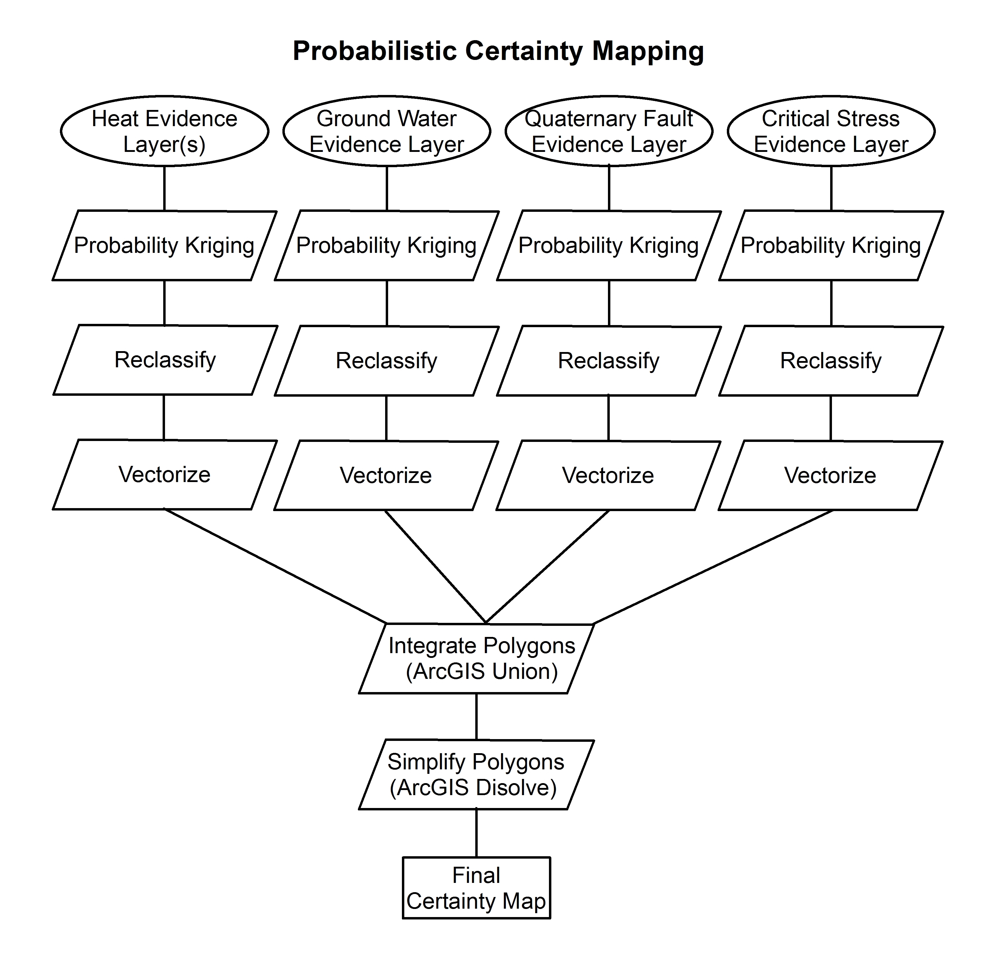
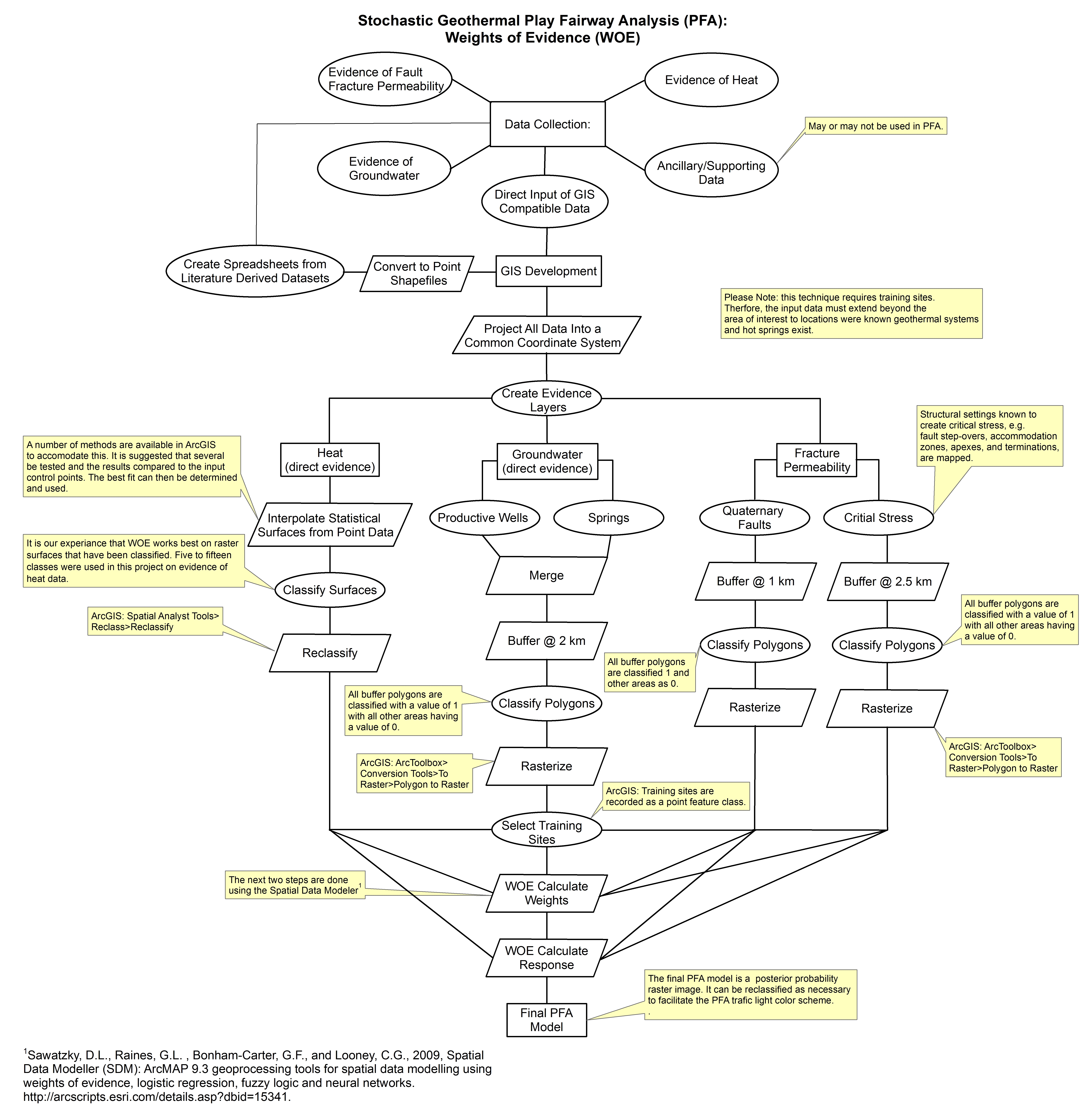
Tularosa Basin Play Fairway Analysis: Methodology Flow Charts
Department of Energy —
These images show the comprehensive methodology used for creation of a Play Fairway Analysis to explore the geothermal resource potential of the Tularosa Basin, New... -
Federal
Play Fairway Analysis Retrospective GeoRePORTs
Department of Energy —
NREL, as part of the Play Fairway Analysis (PFA) Retrospective and with assistance from PFA PIs, completed GeoRePORTs for the sites identified in Phases 1&2 of... -
Federal
Tularosa Basin Play Fairway Analysis: Pleistocene Lake Otero
Department of Energy —
This submission includes a geotiff of the geographic extent of Pleistocene Lake Otero; which was used as apart of the groundwater composite risk segment in a Tularosa... -
Federal
Innovative Play Fairway Modelling Applied to the Tularosa Basin Project Report
Department of Energy —
This report describes all of the work done in Phase I of a geothermal exploration project in the Tularosa Basin, as well as an outline for Phase II work, and more. -
Federal
Tularosa Basin Play Fairway Analysis: Weights of Evidence; Mineralogy, and Temperature Anomaly Maps
Department of Energy —
This submission has two shapefiles and a tiff image. The weights of evidence analysis was applied to data representing heat of the earth and fracture permeability... -
Federal
Tularosa Basin Play Fairway Analysis: White Sands Missile Range Main Cantonment and NASA Area Faults, New Mexico
Department of Energy —
This is a zipped ArcGIS shapefile containing faults mapped for the Tularosa Basin geothermal play fairway analysis project. The faults were interpolated from gravity... -
Federal
Fort Bliss Geothermal Area Data: Temperature Profile, Logs, Schematic Model and Cross Section
Department of Energy —
This dataset contains a variety of data about the Fort Bliss geothermal area, part of the southern portion of the Tularosa Basin, New Mexico. The dataset contains... -
Federal
Tularosa Basin Play Fairway Analysis: Hydrothermal Alteration Map
Department of Energy —
This is a hydrothermal alteration map of the Tularosa Basin area, New Mexico and Texas that was created using Advanced Spaceborne Thermal Emission and Reflection... -
Federal
Tularosa Basin Play Fairway Analysis: Raw MT Data for the McGregor Range, Fort Bliss, New Mexico
Department of Energy —
This is a zipped file containing raw magnetotelluric (MT) data collected as part of the Phase 2 Tularosa Basin geothermal play fairway analysis project in New Mexico.... -
Federal
Tularosa Basin Play Fairway Analysis: Partial Basin and Range Heat and Zones of Critical Stress Maps
Department of Energy —
Interpolated maps of heat flow, temperature gradient, and quartz geothermometers are included as TIF files. Zones of critical stress map is also included as a TIF...
12 datasets found