
-
University
Rio Grande Channel, Northern Mesilla Valley, NM, 1891 recent views
Earth Data Analysis Center, University of New Mexico —
Map of Mesilla Valley showing 1891 Rio Grande River channel. Scale 1 inch - 1 mile. -
University
Rio Grande Channel, Northern Mesilla Valley, NM, 1881 recent views
Earth Data Analysis Center, University of New Mexico —
Map of Mesilla Valley showing 1881 Rio Grande River channel. Scale 1 inch - 1 mile. -
University
Rio Grande Channel, Northern Mesilla Valley, NM, 1912 recent views
Earth Data Analysis Center, University of New Mexico —
Map of Mesilla Valley showing, showing channel of the Rio Grande River of an unknown date.. Scale 1 inch - 1 mile. -
Federal
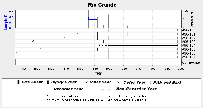
NOAA/WDS Paleoclimatology - Veblen fire data from Rio Grande - IMPD ARRGR001 recent views
National Oceanic and Atmospheric Administration, Department of Commerce —
This archived Paleoclimatology Study is available from the NOAA National Centers for Environmental Information (NCEI), under the World Data Service (WDS) for... -
Federal
Historic Inventory of Acropora Around Puerto Rico and U.S. Virgin Islands recent views
National Oceanic and Atmospheric Administration, Department of Commerce —
Atlantic acroporid corals were listed as threatened under the Endangered Species Act (ESA) of 1973 on May 9, 2006, and a 4(d) rule was final on October 29, 2008,... -
Federal
H00377: NOS Hydrographic Survey recent views
National Oceanic and Atmospheric Administration, Department of Commerce —
The National Oceanic and Atmospheric Administration (NOAA) has the statutory mandate to collect hydrographic data in support of nautical chart compilation for safe... -
University
Rio Grande Channel, Northern Mesilla Valley, NM, 1903 recent views
Earth Data Analysis Center, University of New Mexico —
Map of Mesilla Valley showing 1903 Rio Grande River channel. Scale 1 inch - 1 mile. -
University
Rio Grande Channel, Northern Mesilla Valley, NM, before 1844 recent views
Earth Data Analysis Center, University of New Mexico —
Map of Mesilla Valley showing channel of the Rio Grande River previous to 1844. Scale 1 inch - 1 mile. -
Federal
TIGER/Line Shapefile, 2021, County, Rio Grande County, CO, All Roads recent views
U.S. Census Bureau, Department of Commerce —
The TIGER/Line shapefiles and related database files (.dbf) are an extract of selected geographic and cartographic information from the U.S. Census Bureau's Master... -
University
Rio Grande Channel, Southern Mesilla Valley, NM, 1903 recent views
Earth Data Analysis Center, University of New Mexico —
Map of Mesilla Valley showing 1903 channel of the Rio Grande River. Scale 1 inch - 1 mile. -
University
Northern Edge of Mesilla Valley, NM, 1914 recent views
Earth Data Analysis Center, University of New Mexico —
Map of Mesilla Valley showing valley edge. Scale 1 inch - 1 mile. -
University
Rio Grande Channel, Northern Mesilla Valley, NM, 1907 recent views
Earth Data Analysis Center, University of New Mexico —
Map of Mesilla Valley showing 1907 Rio Grande River channel. Scale 1 inch - 1 mile. -
University
Rio Grande Channel, Northern Mesilla Valley, NM, 1844 recent views
Earth Data Analysis Center, University of New Mexico —
Map of Mesilla Valley showing 1844 Rio Grande River channel. Scale 1 inch - 1 mile. -
University
Rio Grande Channel, Southern Mesilla Valley, NM, before 1844 recent views
Earth Data Analysis Center, University of New Mexico —
Map of Mesilla Valley showing various known channels of the Rio Grande River. Scale 1 inch - 1 mile. -
University
Rio Grande Channel, Southern Mesilla Valley, NM, 1912 recent views
Earth Data Analysis Center, University of New Mexico —
Map of Mesilla Valley showing 1912 channel of the Rio Grande River. Scale 1 inch - 1 mile. -
University
Rio Grande Channel, Northern Mesilla Valley, NM, unknown date recent views
Earth Data Analysis Center, University of New Mexico —
Map of Mesilla Valley showing channel of the Rio Grande River of an unknown date. Scale 1 inch - 1 mile. -
University
Southern Edge Mesilla Valley, NM, 1914 recent views
Earth Data Analysis Center, University of New Mexico —
Map of Mesilla Valley showing valley edge. Scale 1 inch - 1 mile. -
Federal
TIGER/Line Shapefile, 2022, County, Rio Grande County, CO, Area Hydrography recent views
U.S. Census Bureau, Department of Commerce —
The TIGER/Line shapefiles and related database files (.dbf) are an extract of selected geographic and cartographic information from the U.S. Census Bureau's Master... -
Federal
TIGER/Line Shapefile, 2022, County, Rio Grande County, CO, All Lines recent views
U.S. Census Bureau, Department of Commerce —
The TIGER/Line shapefiles and related database files (.dbf) are an extract of selected geographic and cartographic information from the U.S. Census Bureau's Master... -
Federal
TIGER/Line Shapefile, Current, County, Rio Grande County, CO, All Roads recent views
U.S. Census Bureau, Department of Commerce —
This resource is a member of a series. The TIGER/Line shapefiles and related database files (.dbf) are an extract of selected geographic and cartographic information...

Official websites use .gov
A
.gov website belongs to an official government
organization in the United States.
Secure .gov websites use HTTPS
A
lock (
) or https:// means you’ve safely connected to
the .gov website. Share sensitive information only on official,
secure websites.