
-
Federal
Reference Data Set of Human Skin Reflectance
National Institute of Standards and Technology —
This data set contains 100 reference reflectance spectra of human skin, spanning the wavelength region from 250 nm to 2500 nm. The spectra were acquired with a... -
Federal
NOAA Geostationary Operation Environmental Satellite-R Series (GOES-R Series) Advanced Baseline Imager (ABI) Level 2 Cloud and Moisture Imagery Products (CMIP).
National Oceanic and Atmospheric Administration, Department of Commerce —
The Cloud and Moisture Imagery product contains one or more Earth-view images with pixel values identifying brightness values that are scaled to support visual... -
Federal
NOAA Geostationary Operational Environmental Satellite (GOES) I-M and N-P Series Imager Data NGDA
National Oceanic and Atmospheric Administration, Department of Commerce —
The NOAA Geostationary Operational Environmental Satellite (GOES) series provides continuous measurements of the atmosphere and surface over the Western Hemisphere.... -
Federal
NOAA Climate Data Record (CDR) of Visible and Near Infrared Reflectance from AVHRR, Version 1.0
National Oceanic and Atmospheric Administration, Department of Commerce —
The AVHRR visible gains and offsets convert GAC pixel level counts to radiances and are provided for each visible band encompassing TIROS-N, NOAA-6 through NOAA-19... -
Federal
Coking coal of the United States: Modern and historical locations of coking coal mining locations and chemical, rheological, petrographic, and other data from modern samples
Department of the Interior —
For the open-file report we collected new coking coal samples from Alabama, Kentucky, Oklahoma and Arkansas and analyzed them for proximate and ultimate analyses;... -
Federal
2010 North American Land Cover 250-Meter
Department of Agriculture —
The 2010 North American Land Cover data set was produced as part of the North American Land Change Monitoring System (NALCMS), a trilateral effort between the Canada... -
Federal
North American Land Change Monitoring System (NALCMS) Products NGDA
Department of the Interior —
The 2020 North American Land Cover 30-meter dataset was produced as part of the North American Land Change Monitoring System (NALCMS), a trilateral effort between... -
Federal
NOAA Polar-orbiting Operational Environmental Satellites (POES) Radiometer Data NGDA
National Oceanic and Atmospheric Administration, Department of Commerce —
The Polar-orbiting Operational Environmental Satellite (POES) series offers the advantage of daily global coverage, by making nearly polar orbits 14 times per day... -
Federal
ESA CCI Ocean Colour Product (CCI ALL-v5.0-DAILY), 0.04166666°, 1997-present, Lon0360
National Oceanic and Atmospheric Administration, Department of Commerce —
Data products generated by the Ocean Colour component of the European Space Agency Climate Change Initiative project. These files are daily composites of merged... -
Federal
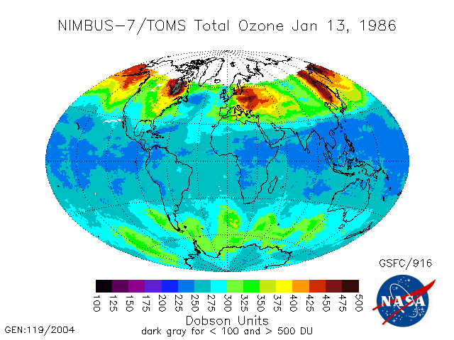
TOMS Nimbus-7 Total Ozone Aerosol Index UV-Reflectivity UV-B Erythemal Irradiances Daily L3 Global 1 deg x 1.25 deg V008 (TOMSN7L3) at GES DISC
National Aeronautics and Space Administration —
The Nimbus-7 Total Ozone Mapping Spectrometer (TOMS) version 8 daily global gridded data product contains total column ozone, UV aerosol index, Lambertian effective... -
Federal
ESA CCI Ocean Colour Product (CCI ALL-v5.0-MONTHLY), 0.04166666°, 1997-present
National Oceanic and Atmospheric Administration, Department of Commerce —
Data products generated by the Ocean Colour component of the European Space Agency Climate Change Initiative project. These files are monthly composites of merged... -
Federal
Reflectance and spectral fluorescence data from the effect of diagenesis on the preservation of morphology and ultrastructural features of pollen
Department of the Interior —
Pollen morphology and pollen morphology in conjunction with other characteristics have elucidated the origin and evolution of various plant groups. Many studies of... -
Federal
VIIRSN, Suomi-NPP, Level-3 SMI, NASA, Global, 4km, Reflectance at 671 nm, R2018, 2012-present, Monthly, Lon0360
National Oceanic and Atmospheric Administration, Department of Commerce —
R2018 of Level-3 Standard Mapped Image (SMI), Global, 4km, Remote Sensing Reflectance at 671 nm, Monthly composite data from the Visible and Infrared... -
Federal
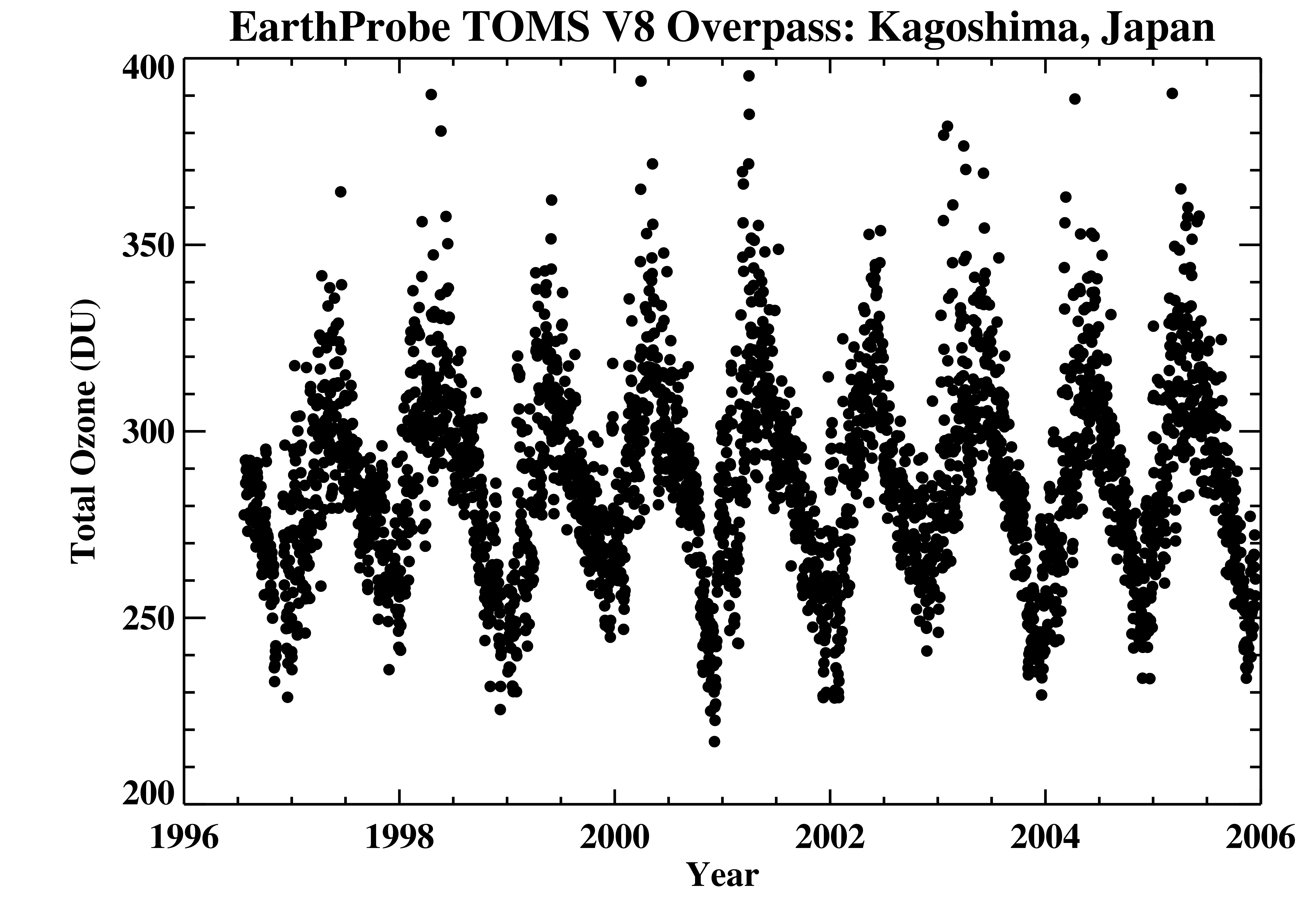
TOMS Earth Probe Ground Station Overpass Data V008 (TOMSEPOVP) at GES DISC
National Aeronautics and Space Administration —
The Earth Probe (EP) Total Ozone Mapping Spectrometer (TOMS) version 8 daily ground station overpass data product contains total column ozone, UV aerosol index,... -
Federal
ESA CCI Ocean Colour Product (CCI ALL-v4.2-DAILY), 0.04166666°, 1997-2019
National Oceanic and Atmospheric Administration, Department of Commerce —
Data products generated by the Ocean Colour component of the European Space Agency Climate Change Initiative project. These files are daily composites of merged... -
Federal
Remote Sensing Reflectance at 667 nm, Aqua MODIS, NPP, Gulf of Mexico, 2002-2012 (8 Day Composite), Lon0360
National Oceanic and Atmospheric Administration, Department of Commerce —
MODIS measures the remote sensing reflectance (Rrs) at 667nm. This can be used to view very high concentrations of phytoplankton in the very surface of the water. -
Federal
TOMS Earth-Probe Ozone (O3) Total Column 1-Orbit L2 Swath 50 x 50 km V008 (TOMSEPL2) at GES DISC
National Aeronautics and Space Administration —
The Earth Probe (EP) Total Ozone Mapping Spectrometer (TOMS) version 8 orbital swath data product contains total column ozone, UV aerosol index, and Lambertian... -
Federal
NOAA Climate Data Record (CDR) of Gridded Satellite Data from ISCCP B1 (GridSat-B1) Infrared Channel Brightness Temperature, Version 2
National Oceanic and Atmospheric Administration, Department of Commerce —
The Gridded Satellite (GridSat-B1) data provides a uniform set of quality controlled geostationary satellite observations for the visible, infrared window and... -
Federal
Field Spectra from the upper Sacramento River in northern California, September 11-14, 2017
Department of the Interior —
Field spectra were collected from a reach of the upper Sacramento River in northern California, September 11-14, 2017, to support research on remote sensing of... -
Federal
C-HARM v2 Nowcast, Pseudo-nitzschia, cellular domoic acid, and particular domoic acid probability, California and Southern Oregon coast, 2022-present
National Oceanic and Atmospheric Administration, Department of Commerce —
The C-HARM model generates nowcast and forecasts of the probability of Pseudo-nitzschia concentrations of in excess of 10,000 cells/L, the probability of particulate...

Official websites use .gov
A
.gov website belongs to an official government
organization in the United States.
Secure .gov websites use HTTPS
A
lock (
) or https:// means you’ve safely connected to
the .gov website. Share sensitive information only on official,
secure websites.