

36 datasets found
-
Federal
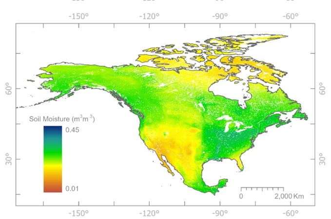
NASMo-TiAM 250m 16-day North America Surface Soil Moisture Dataset
National Aeronautics and Space Administration —
This NASMo-TiAM (North America Soil Moisture Dataset Derived from Time-Specific Adaptable Machine Learning Models) dataset holds gridded estimates of surface soil... -
Federal
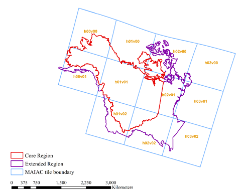
ABoVE: Angular-corrected MODIS MAIAC Reflectance across Alaska and Canada, 2000-2017 NGDA
National Aeronautics and Space Administration —
This dataset provides angular corrections of MODIS Multi-Angle Implementation of Atmospheric Correction algorithm (MAIAC) surface reflectances across the ABoVE domain... -
Federal
ABoVE: Light-Curve Modelling of Gridded GPP Using MODIS MAIAC and Flux Tower Data NGDA
National Aeronautics and Space Administration —
This dataset contains gridded estimations of daily ecosystem Gross Primary Production (GPP) in grams of carbon per day at a 1 km2 spatial resolution over Alaska and... -
Federal
Pre-ABoVE: Ground-penetrating Radar Measurements of ALT on the Alaska North Slope
National Aeronautics and Space Administration —
This data set includes estimates of permafrost Active Layer Thickness (ALT; cm), and calculated uncertainties, derived using a ground-penetrating radar (GPR) system... -
Federal
ABoVE: Year-Round Soil CO2 Efflux in Alaskan Ecosystems, Version 2.1
National Aeronautics and Space Administration —
This dataset provides soil-surface carbon dioxide (CO2) efflux derived from measurements of soil respiration with forced diffusion (FD) chambers. Soil Respiration... -
Federal
SiB4 Modeled Global 0.5-Degree Daily Carbon Fluxes and Pools, 2000-2018
National Aeronautics and Space Administration —
This dataset provides global daily output predicted by the Simple Biosphere Model, Version 4.2 (SiB4), at a 0.5-degree spatial resolution covering the time period... -
Federal
Export and Leaching of Carbon and Nitrogen from Mississippi River Basin, 1901-2099
National Aeronautics and Space Administration —
This dataset provides estimates for export and leaching of dissolved inorganic carbon (DIC), dissolved organic carbon (DOC), total organic carbon (TOC), particulate... -
Federal
Lund-Potsdam-Jena Wetland Hydrology and Methane DGV Model (LPJ-WHyMe v1.3.1)
National Aeronautics and Space Administration —
This model product provides the Fortran 77 source code for the Lund-Potsdam-Jena (LPJ) Wetland Hydrology and Methane Dynamic Global Vegetation Model (LPJ-WHyMe... -
Federal
ECOSTRESS Gridded Downscaled Soil Moisture Instantaneous L3 Global 70 m V002
National Aeronautics and Space Administration —
The ECOsystem Spaceborne Thermal Radiometer Experiment on Space Station (ECOSTRESS) mission measures the temperature of plants to better understand how much water... -
Federal
ABoVE: Active Layer Thickness from Airborne L- and P- band SAR, Alaska, 2017, Ver. 3
National Aeronautics and Space Administration —
This dataset provides estimates of seasonal subsidence, active layer thickness (ALT), the vertical soil moisture profile, and uncertainties at a 30 m resolution for... -
Federal
Trends of Thermal, Wetness, and Vegetative Change in the Circumpolar Arctic
National Aeronautics and Space Administration —
This dataset provides estimates of trends in temperature, moisture, and vegetation changes over the circumpolar Arctic. Time series trends were measured by the Theil-... -
Federal
Lund-Potsdam-Jena Wetland Hydrology and Methane DGV Model (LPJ-WHyMe v1.3.1)
National Aeronautics and Space Administration —
This model product provides the Fortran 77 source code for the Lund-Potsdam-Jena (LPJ) Wetland Hydrology and Methane Dynamic Global Vegetation Model (LPJ-WHyMe... -
Federal
ECOSTRESS Tiled Downscaled Soil Moisture Instantaneous L3 Global 70 m V002
National Aeronautics and Space Administration —
The ECOsystem Spaceborne Thermal Radiometer Experiment on Space Station (ECOSTRESS) mission measures the temperature of plants to better understand how much water... -
Federal
ECOSTRESS Gridded Downscaled Soil Moisture Instantaneous L3 Global 70 m V002
National Aeronautics and Space Administration —
The ECOsystem Spaceborne Thermal Radiometer Experiment on Space Station (ECOSTRESS) mission measures the temperature of plants to better understand how much water... -
Federal
ECOSTRESS Tiled Downscaled Soil Moisture Instantaneous L3 Global 70 m V002
National Aeronautics and Space Administration —
The ECOsystem Spaceborne Thermal Radiometer Experiment on Space Station (ECOSTRESS) mission measures the temperature of plants to better understand how much water...
36 datasets found