
-
Federal
MODIS/Terra+Aqua BRDF Model Parameters Daily L3 Global 1km SIN Grid V061 NGDA
National Aeronautics and Space Administration —
The MCD19A3D Version 6.1 data product is a Moderate Resolution Imaging Spectroradiometer (MODIS) Terra and Aqua combined Bidirectional Reflectance Distribution... -
Federal
AirMOSS: L4 Modeled Volumetric Root Zone Soil Moisture, 2012-2015
National Aeronautics and Space Administration —
This data set provides hourly gridded soil moisture estimates derived from hydrologic modeling at nine AirMOSS sites across North America. The AirMOSS L4 RZSM product... -
Federal
ABoVE: Lake Growing Season Green Surface Reflectance Trends, AK and Canada, 1984-2019
National Aeronautics and Space Administration —
This dataset provides an annual time series of Landsat green surface reflectance and the derived annual trend during the growing season (June and July) for 472,890... -
Federal
GPM Ground Validation Airborne Snow Observatory (ASO) OLYMPEX V1
National Aeronautics and Space Administration —
The GPM Ground Validation Airborne Snow Observatory (ASO) OLYMPEX dataset consists of snow depth, bare earth surface, land surface classification and a Red, Green,... -
Federal
Arctic Vegetation Plots in Willow Communities, North Slope, Alaska, 1997
National Aeronautics and Space Administration —
This data set provides environmental, soil, and vegetation data collected in July and August 1997 from 85 study plots in willow shrub communities located along a... -
Federal
LBA-ECO LC-14 Root Biomass and Phenology, km 67 Site, Para, Brazil: 2001
National Aeronautics and Space Administration —
This data set contains biomass estimates for coarse roots measured on the forest floor and measurements of fine root growth down to 2-m depth at the km 67 Rainfall... -
Federal
Pre-Delta-X: Water Levels across Wax Lake Outlet, Atchafalaya Basin, LA, USA, 2016
National Aeronautics and Space Administration —
This dataset provides absolute water level elevations derived for 10 locations across the Wax Lake Delta, Atchafalaya Basin, in Southern Louisiana, USA, within the... -
Federal
Global Peatland Carbon Balance and Land Use Change CO2 Emissions Through the Holocene
National Aeronautics and Space Administration —
This data set provides a time series of global peatland carbon balance and carbon dioxide emissions from land use change throughout the Holocene (the past 11,000... -
Federal
BOREAS HYD-01 Volumetric Soil Moisture Data
National Aeronautics and Space Administration —
Contains the percent soil moisture by volume data that was collected by the HYD-01 group at the various tower sites. -
Federal
Geoecology: County-Level Environmental Data for the United States, 1941-1981
National Aeronautics and Space Administration —
The Geoecology database is a compilation of environmental data for the period 1941 to 1981. The Geoecology database contains selected data on terrain and soils, water... -
Federal
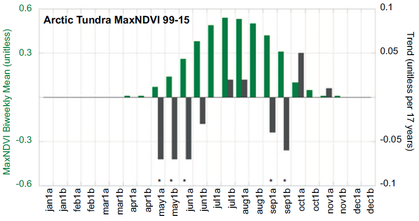
ABoVE: Climate Drivers of Pan-Arctic Tundra Vegetation Productivity, 1982-2015
National Aeronautics and Space Administration —
This dataset provides a summary of potential climate drivers of Arctic tundra vegetation productivity that have been compiled for growing seasons from 1982 to 2015.... -
Federal
Soil Moisture Active Passive (SMAP) L4 Soil Moisture Ancillary Restart Files V001
National Aeronautics and Space Administration —
This ancillary SMAP product contains static restart files for the Land Data Assimilation Systems (LDAS) Catchment model. This product includes prognostic variables... -
Federal
Committee on Earth Observation Satellites (CEOS) International Directory Portal
National Aeronautics and Space Administration —
The CEOS IDN is an international effort developed to assist researchers in locating information on available datasets and services. The directory is sponsored as a... -
Federal
Resilience of Coastal Wetlands to Sea Level Rise, CONUS, 1996-2100
National Aeronautics and Space Administration —
This dataset provides information about the resilience of tidal wetlands to sea-level rise under three scenarios of global change. With rising seas, regularly... -
Federal
Coastal Wetland Elevation and Carbon Flux Inventory with Uncertainty, USA, 2006-2011
National Aeronautics and Space Administration —
This dataset provides maps of coastal wetland carbon and methane fluxes and coastal wetland surface elevation from 2006 to 2011 at 30 m resolution for coastal... -
Federal
NCA-LDAS Noah-3.3 Land Surface Model L4 Trends 0.125 x 0.125 degree V2.0 (NCALDAS_NOAH0125_Trends) at GES DISC
National Aeronautics and Space Administration —
The National Climate Assessment - Land Data Assimilation System, or NCA-LDAS, is a terrestrial water reanalysis in support of the United States Global Change Research... -
Federal
Projections of Permafrost Thaw and Carbon Release for RCP 4.5 and 8.5, 1901-2299
National Aeronautics and Space Administration —
This dataset consists of an ensemble of model projections from 1901 to 2299 for the northern hemisphere permafrost domain. The model projections include monthly... -
Federal
ABoVE: Landsat Vegetation Greenness Trends, Boreal Forest Biome, 1985-2019
National Aeronautics and Space Administration —
This dataset provides information on interannual trends in annual maximum vegetation greenness from 1985 to 2019 for recently undisturbed areas in the boreal forest...

Official websites use .gov
A
.gov website belongs to an official government
organization in the United States.
Secure .gov websites use HTTPS
A
lock (
) or https:// means you’ve safely connected to
the .gov website. Share sensitive information only on official,
secure websites.