

20 datasets found
-
Federal
USDA Beltsville Agricultural Research Center (BARC) Gridded Yield Data Archive, version 1
Department of Agriculture —
[Note, 1/20/2026: Farm management PDF files added.]The USDA Beltsville Agricultural Research Center (BARC) Gridded Yield Data Archive is a multi-year, gridded yield... -
Federal
Distribution of the Yellowstone Grizzly Bear (2000-2014)
Department of the Interior —
The grizzly bear distribution boundary delineates the estimated geographic extent of occupied range of the Yellowstone grizzly bear population for the period... -
Federal
Grid Cells and Modeled Groundwater Levels to Characterize Hydrologic Conditions for Public-supply Aquifers in California's Central Valley, 1990-2020
Department of the Interior —
This data release documents grid cells and modeled groundwater levels for hydrologic characterization of aquifer areas used for public drinking-water supply in... -
Federal
Data for generating statistical maps of soil lithium concentrations in the conterminous United States
Department of the Interior —
The product data are six statistics that were estimated for the chemical concentration of lithium in the soil C horizon of the conterminous United States. The... -
Federal
Groundwater elevation data and models in and around select California oil fields (ver. 3.0, September 2025)
Department of the Interior —
This data release contains groundwater elevation data and the associated model/code used to create groundwater elevation surfaces in and around select oil fields in... -
Federal
Datasets used to map the base-flow recession time constants in the Niobrara National Scenic River in Nebraska, 2016-18
Department of the Interior —
The base flow recession time constant (tau) is a hydrologic index that characterizes the ability of a ground-water system to supply flow to a stream draining from... -
Federal
Digital surfaces and site data of well-screen top and bottom altitudes defining the irrigation production zone of the Mississippi River Valley alluvial aquifer within the Mississippi Alluvial Plain project region
Department of the Interior —
Site data contained in the ScrIntrvls_AllSrcRefs_AllWellsRev.csv dataset define the top and bottom altitudes of well screens in 64,763 irrigation wells completed in... -
Federal
Base-flow recession time constant (tau) contours in the Niobrara National Scenic River in Nebraska, 2016-18
Department of the Interior —
This dataset contains base-flow recession time constant (tau) contours that are interpreted from tau values calculated at streamgages in the Niobrara National Scenic... -
Federal
Estimated groundwater elevations and standard errors from the application of kriging to median groundwater elevation data from 2010 in the Mesilla/Conejos-Médanos Basin, United States and Mexico
Department of the Interior —
These data include 217 median groundwater elevations computed from compiled measurements made in the year 2010 within the transboundary Mesilla/Conejos-Médanos Basin,... -
Federal
Data for generating statistical maps of soil cobalt concentrations in the conterminous United States
Department of the Interior —
The product data are six statistics that were estimated for the chemical concentration of cobalt in the soil C horizon of the conterminous United States (Smith and... -
Federal
Oregon Cascades Play Fairway Analysis: Faults and Heat Flow Maps
Department of Energy —
This submission includes a fault map of the Oregon Cascades and backarc, a probability map of heat flow, and a fault density probability layer. More extensive... -
Federal
Spatial Point Data Sets and Interpolated Surfaces of Well Construction Characteristics for Domestic and Public Supply Wells in the Central Valley, California, USA.
Department of the Interior —
Well construction data for 11,917 domestic and 2,390 public-supply wells in the Central Valley were compiled as part of the U.S. Geological Survey (USGS) National... -
Federal
Digital Surfaces of the bottom altitude and thickness of the Mississippi River Valley alluvial aquifer and site data within the Mississippi Alluvial Plain project region
Department of the Interior —
Bottom altitudes of the Mississippi River Valley alluvial aquifer (MRVA) were compiled from interpretations of subsurface geophysical logs (log picks) at about 10,000... -
Federal
Estimated_logYield_kriging_Predicted_standard_error_NashobaTerrane
Department of the Interior —
This data set contains standard error in the kriging prediction of estimated yield of bedrock wells in grid cells of 200x200 meters in the Nashoba Terrane and... -
Federal
Oregon Cascades Play Fairway Analysis: Maps
Department of Energy —
The maps in this submission include: heat flow, alkalinity, Cl, Mg, SiO2, Quaternary volcanic rocks, faults, and land ownership. All of the Oregon Cascade region. The... -
Federal
Appalachian Basin Play Fairway Analysis: Thermal Quality Analysis in Low-Temperature Geothermal Play Fairway Analysis (GPFA-AB)
Department of Energy —
This collection of files are part of a larger dataset uploaded in support of Low Temperature Geothermal Play Fairway Analysis for the Appalachian Basin (GPFA-AB).... -
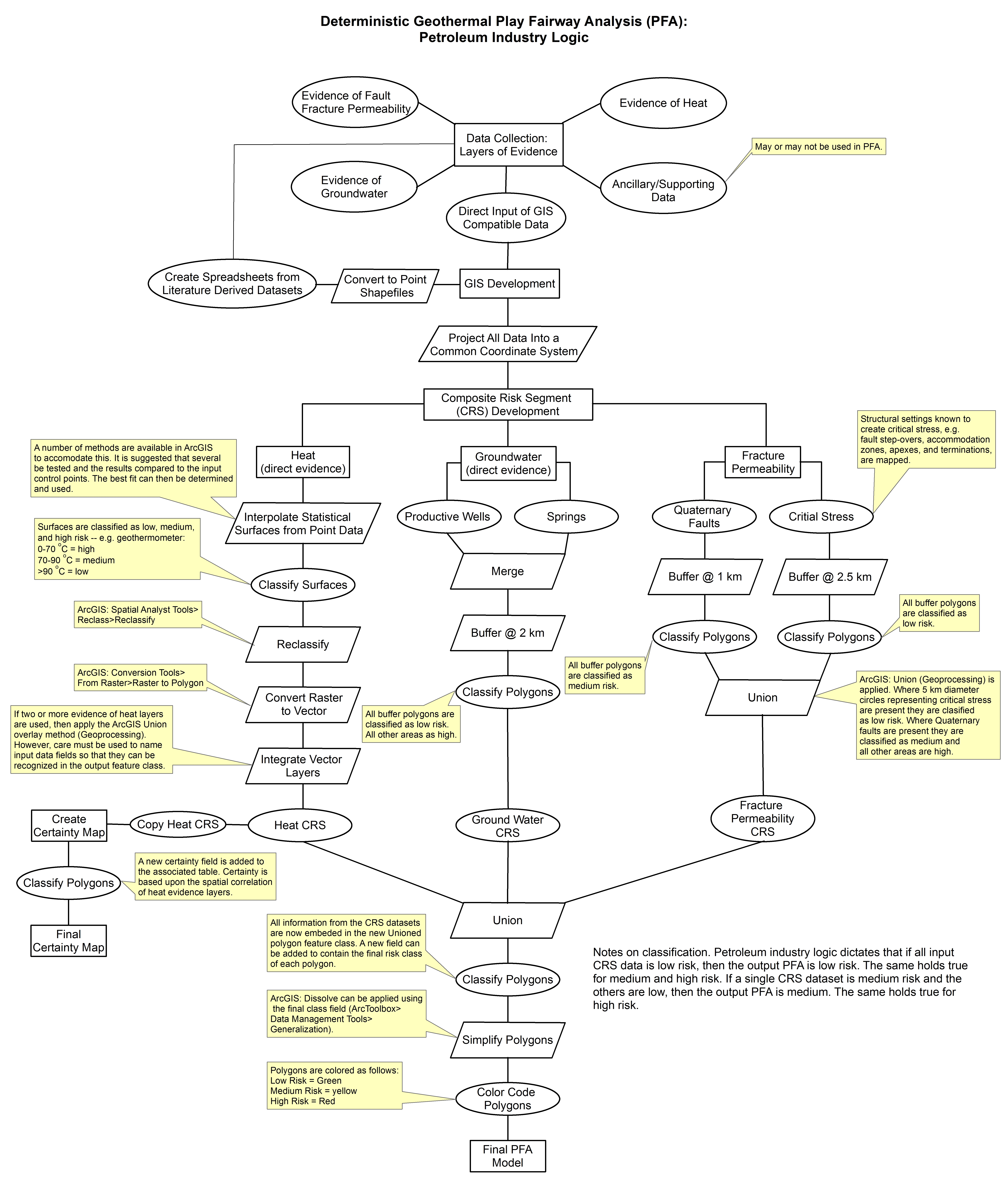
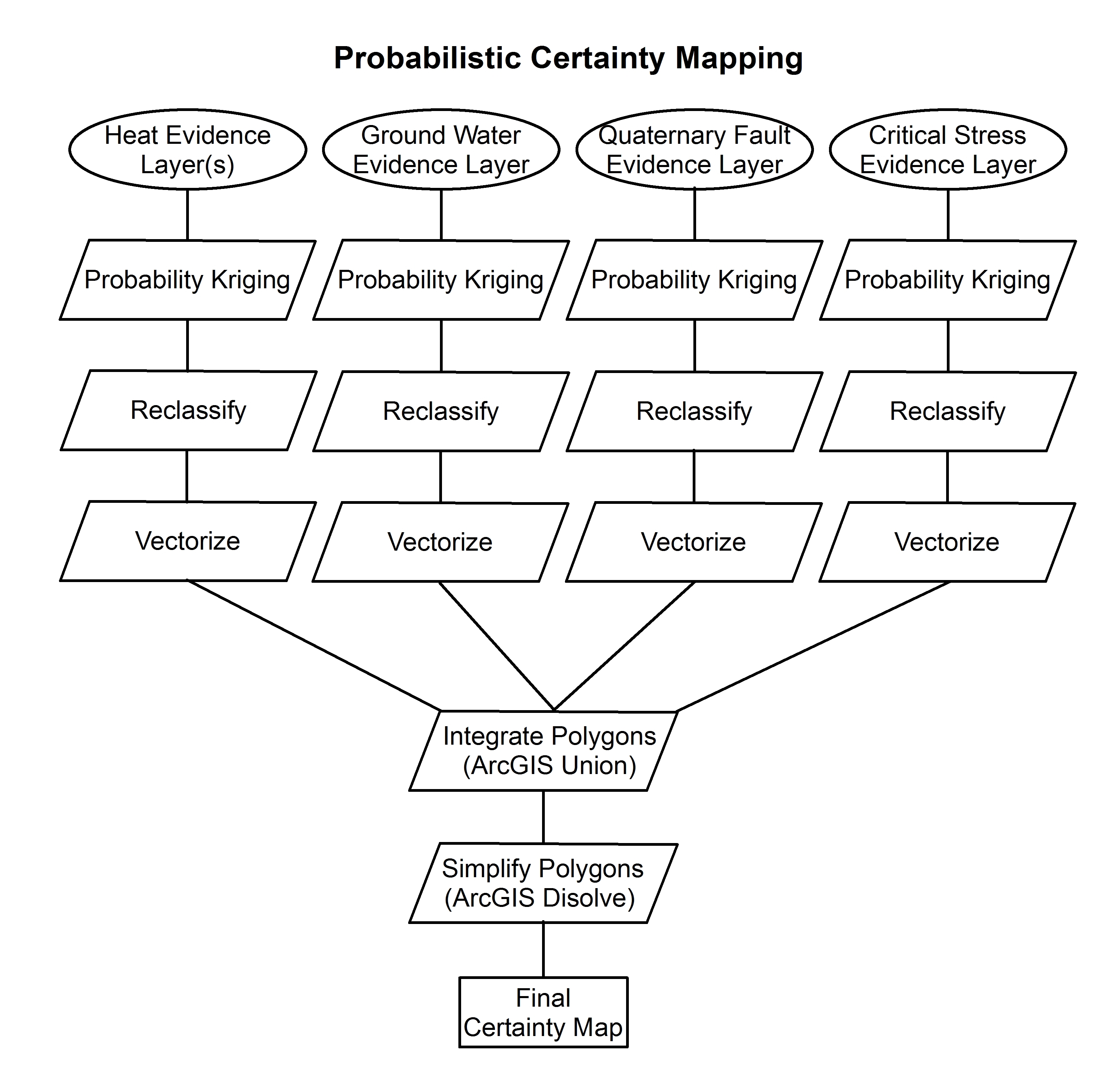
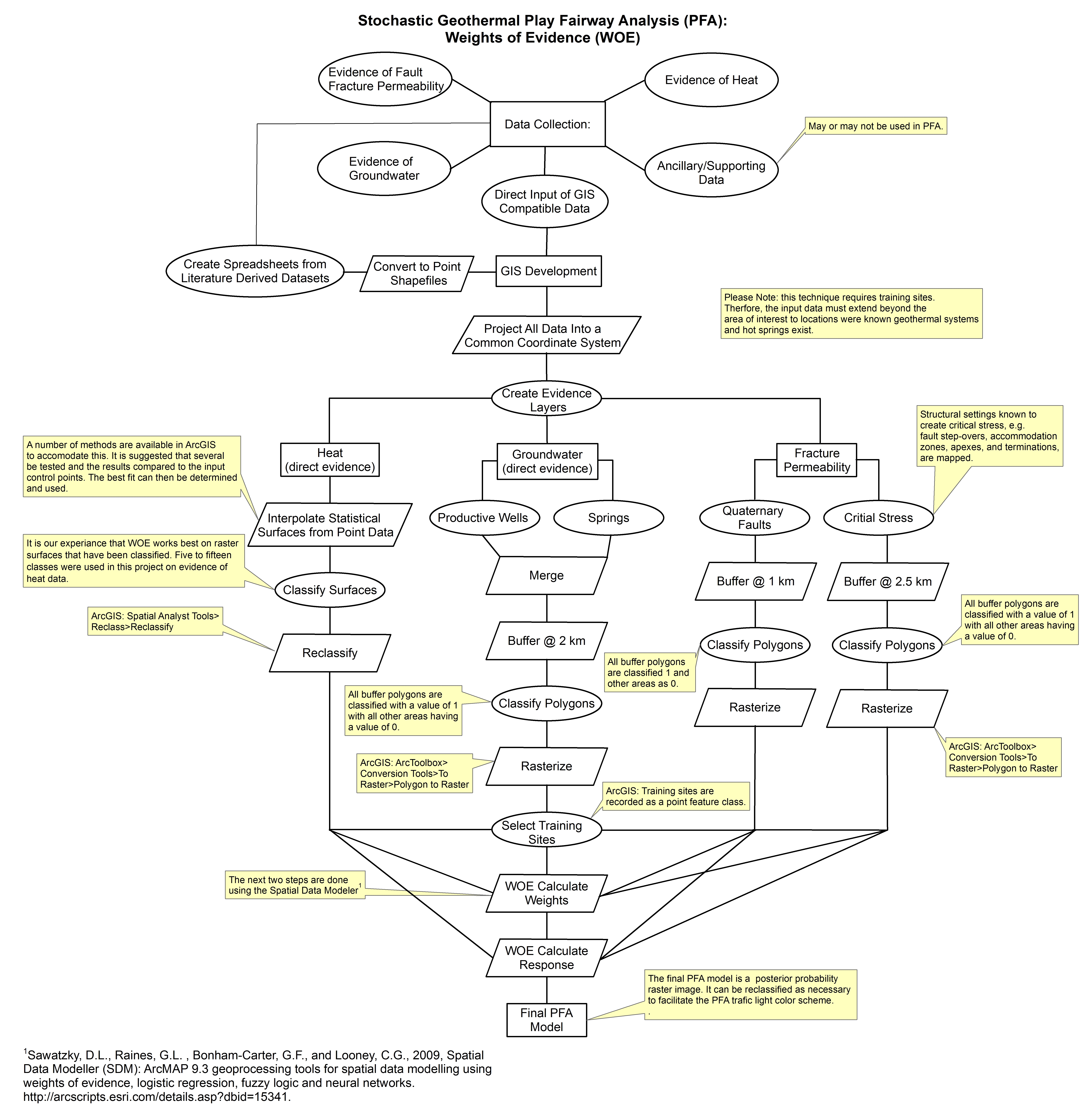
Federal
Tularosa Basin Play Fairway Analysis: Methodology Flow Charts
Department of Energy —
These images show the comprehensive methodology used for creation of a Play Fairway Analysis to explore the geothermal resource potential of the Tularosa Basin, New... -
Federal
Data for generating statistical maps of soil lanthanum concentrations in the conterminous United States
Department of the Interior —
The product data are six statistics that were estimated for the chemical concentration of lanthanum in the soil C horizon of the conterminous United States (Smith and... -
Federal
Geospatial Tools Effectively Estimate Nonexceedance Probabilities of Daily Streamflow at Ungauged and Intermittently Gauged Locations in Ohio: Data Release
Department of the Interior —
This data set archives all inputs, outputs and scripts needed to reproduce the findings of W.H. Farmer and G.F. Koltun in the 2017 Journal of Hydrology Regional...
20 datasets found