
-
Federal
Local Observations from the Seasonal Ice Zone Observing Network (SIZONet) and Alaska Arctic Observatory and Knowledge Hub (AAOKH), Version 2
National Aeronautics and Space Administration —
The Seasonal Ice Zone Observing Network (SIZONet) and the Alaska Arctic Observatory and Knowledge Hub (AAOKH) share the Local Observations Interface, which allows... -
Federal
Global Forest Ecosystem Structure and Function Data For Carbon Balance Research
National Aeronautics and Space Administration —
A comprehensive global database has been assembled to quantify CO2 fluxes and pathways across different levels of integration (from photosynthesis up to net ecosystem... -
Federal
China Dimensions Data Collection: China County-Level Data on Population (Census) and Agriculture, Keyed to 1:1M GIS Map
National Aeronautics and Space Administration —
The China County-Level Data on Population (Census) and Agriculture, Keyed To 1:1M GIS Map consists of census, agricultural economic, and boundary data for the... -
Federal
Global Database of Light-based Geospatial Income Inequality (LGII) Measures, Version 1
National Aeronautics and Space Administration —
The Global Database of Light-based Geospatial Income Inequality (LGII) Measures, Version 1 data set contains Gini-coefficients of inequality for 234 countries and... -
Federal
Fire Intensity and Burn Severity Metrics for Circumpolar Boreal Forests, 2001-2013 NGDA
National Aeronautics and Space Administration —
This data set provides products characterizing immediate and longer-term ecosystem changes from fires in the circumpolar boreal forests of Northern Eurasia and North... -
Federal
2018 Environmental Performance Index (EPI)
National Aeronautics and Space Administration —
The 2018 Environmental Performance Index (EPI) ranks 180 countries on 24 performance indicators in the following 10 issue categories: air quality, water and... -
Federal
Gridded Population of the World, Version 4 (GPWv4): Population Density, Revision 11
National Aeronautics and Space Administration —
The Gridded Population of the World, Version 4 (GPWv4): Population Density, Revision 11 consists of estimates of human population density (number of persons per... -
Federal
National Aggregates of Geospatial Data Collection: Population, Landscape, And Climate Estimates, Version 4 (PLACE IV)
National Aeronautics and Space Administration —
The National Aggregates of Geospatial Data Collection: Population, Landscape, And Climate Estimates, Version 4 (PLACE IV) provides measures of population (head... -
Federal
1:100,000-scale Digital Line Graphs (DLG) from the U.S. Geological Survey
National Aeronautics and Space Administration —
Digital line graph (DLG) data are digital representations of cartographic information. DLG's of map features are converted to digital form from maps and related... -
Federal
Global Landslide Nowcast from LHASA L4 1 day 1 km x 1 km version 1.1 (Global_Landslide_Nowcast) at GES DISC
National Aeronautics and Space Administration —
The Landslide Hazard Analysis for Situational Awareness (LHASA) model identifies locations with high potential for landslide occurrence at a daily temporal... -
Federal
Vulcan: High-Resolution Annual Fossil Fuel CO2 Emissions in USA, 2010-2015, Version 3
National Aeronautics and Space Administration —
The Vulcan version 3.0 annual dataset provides estimates of annual carbon dioxide (CO2) emissions from the combustion of fossil fuels (FF) and CO2 emissions from... -
Federal
U.S. Population Grids (Summary File 1), 2000: Alabama, Louisiana, Mississippi and Texas, Alpha Version
National Aeronautics and Space Administration —
The U.S. Population Grids (Summary File 1), 2000: Alabama, Louisiana, Mississippi and Texas, Alpha Version data set contains an ARC/INFO Workspace with grids of... -
Federal
Archive of Census Related Products (ACRP): 1980 SAS Transport Files
National Aeronautics and Space Administration —
The 1980 SAS Transport Files portion of the Archive of Census Related Products (ACRP) contains housing and population demographics from the 1980 Summary Tape File... -
Federal
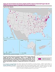
ATSDR Hazardous Waste Site Polygon Data with CIESIN Modifications, Version 2
National Aeronautics and Space Administration —
The Agency for Toxic Substances and Disease Registry (ATSDR) Hazardous Waste Site Polygon Data with CIESIN Modifications, Version 2 is a database providing... -
Federal
2000 Pilot Environmental Sustainability Index (ESI)
National Aeronautics and Space Administration —
The 2000 Pilot Environmental Sustainability Index (ESI) is an exploratory effort to construct an index that measures the ability of a nation's economy to achieve... -
Federal
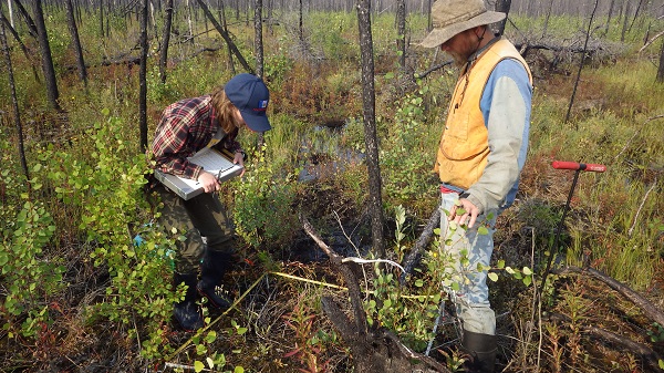
Burned and Unburned Field Site Data, Noatak, Seward, and North Slope, AK, 2016-2018
National Aeronautics and Space Administration —
This dataset includes field measurements from unburned and burned 10 m x 10 m and 1 m x 1 m plots in the Noatak, Seward, and North Slope regions of the Alaskan tundra... -
Federal
ABoVE: Synthesis of Burned and Unburned Forest Site Data, AK and Canada, 1983-2016
National Aeronautics and Space Administration —
This dataset is a synthesis of field plot characterization data, derived above-ground and below-ground combusted carbon, and acquired Fire Weather Index (FWI) System... -
Federal
U.S. Population Grids (Summary File 3), 2000: New Orleans Metropolitan Statistical Area, Alpha Version
National Aeronautics and Space Administration —
The U.S. Population Grids (Summary File 3), 2000: New Orleans Metropolitan Statistical Area, Alpha Version data set contains an ARC/INFO Workspace with grids of... -
Federal
ABoVE: Post-Fire and Unburned Vegetation Community and Field Data, NWT, Canada, 2017
National Aeronautics and Space Administration —
This dataset provides vegetation community characteristics, soil moisture, and biophysical data collected in 2017 from 11 study sites in the ABoVE Study area. The 11...

Official websites use .gov
A
.gov website belongs to an official government
organization in the United States.
Secure .gov websites use HTTPS
A
lock (
) or https:// means you’ve safely connected to
the .gov website. Share sensitive information only on official,
secure websites.