
-
Federal
CERES and GEO-Enhanced TOA, Within-Atmosphere and Surface Fluxes, Clouds and Aerosols 1-Hourly Terra-Aqua-NOAA20 Edition4B
National Aeronautics and Space Administration —
CER_SYN1deg-1Hour_Terra-Aqua-NOAA20_Edition4B is the Clouds and the Earth's Radiant Energy System (CERES) and geostationary (GEO) Top-of-Atmosphere (TOA) Within-... -
Federal
MISR Level 3 Component Global Land Product covering a day subset for the UAE region V004
National Aeronautics and Space Administration —
UAEMRDLS_004 is the Multi-angle Imaging SpectroRadiometer (MISR) Level 3 Component Global Land Product covering a day subset for the UAE region version 4. It contains... -
Federal
MISR Level 3 Component Global Land Regional public Product covering a day V002
National Aeronautics and Space Administration —
MI3DLSR_2 is the Multi-angle Imaging SpectroRadiometer (MISR) Level 3 Component Global Land Regional public Product covering a dayversion 2. It contains a daily... -
Federal
NPP Multi-Biome: Summary Data from Intensive Studies at 125 Sites, 1936-2006
National Aeronautics and Space Administration —
This data set, NPP Multi-Biome: Summary Data from Intensive Studies at 125 Sites, 1936-2006, contains a single shapefile that provides site-level summary statistics... -
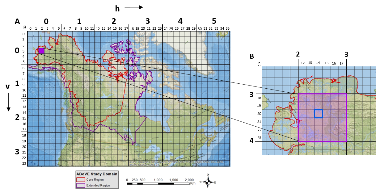
Federal
ABoVE: Study Domain and Standard Reference Grids
National Aeronautics and Space Administration —
The Arctic - Boreal Vulnerability Experiment (ABoVE) has developed two standardized spatial data products to expedite coordination of research activities and to... -
Federal
A Concise Experiment Plan for the Arctic-Boreal Vulnerability Experiment
National Aeronautics and Space Administration —
This document presents the Concise Experiment Plan for NASA's Arctic-Boreal Vulnerability Experiment (ABoVE) to serve as a guide to the Program as it identifies the... -
Federal
Urban Land Cover Maps for Mekelle, Ethiopia and Polokwane, South Africa, 2020
National Aeronautics and Space Administration —
This dataset consists of very high resolution urban land cover maps for two African cities, Mekelle, Ethiopia and Polokwane, South Africa for 2020. Maps were... -
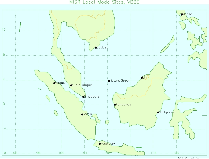
Federal
MISR Level 2 Land Surface Product subset for the VBBE region V002
National Aeronautics and Space Administration —
VBEMI2LS_002 is the Multi-angle Imaging SpectroRadiometer (MISR) Level 2 Land Surface Product subset for the VBBE region version 2. It contains information on land... -
Federal
MISR Level 2 Land Surface parameters subset for the UAE region V002
National Aeronautics and Space Administration —
UAEMIALS_002 is the Multi-angle Imaging SpectroRadiometer (MISR) Level 2 Land Surface parameters subset for the UAE region version 2. It contains information on land... -
Federal
MISR Level 2 Land Surface Product subset for the GoMACCS region V002
National Aeronautics and Space Administration —
GOMI2LS_002 is the Multi-angle Imaging SpectroRadiometer (MISR) Level 2 Land Surface Product subset for the GoMACCS region Version 2 product. It contains information... -
Federal
MISR Level 3 Component Global Land Regional public Product covering a month V002
National Aeronautics and Space Administration —
MI3MLSR_2 is the Multi-angle Imaging SpectroRadiometer (MISR) Level 3 Component Global Land Regional public Product covering a month version 2. It contains a daily... -
Federal
ABoVE: Study Domain and Standard Reference Grids, Version 2
National Aeronautics and Space Administration —
The Arctic - Boreal Vulnerability Experiment (ABoVE) has developed two standardized spatial data products to expedite coordination of research activities and to... -
Federal
Development and Evolution of NASA Satellite Remote Sensing for Ecology
National Aeronautics and Space Administration —
This dataset provides a presentation that highlights the role NASA research and researchers played in developing a wide range of significant, quantitative ecological... -
Federal
GEWEX SRB Integrated Product (Rel-4) Shortwave Monthly Average by Local Fluxes
National Aeronautics and Space Administration —
GEWEXSRB_Rel4-IP_Shortwave_monthly_local is the Global Energy and Water Exchanges (GEWEX) Surface Radiation Budget (SRB) Integrated Product (Rel-4) Shortwave Monthly... -
Federal
GEWEX SRB Integrated Product (Rel-4) Shortwave Daily Average by UTC Fluxes
National Aeronautics and Space Administration —
GEWEXSRB_Rel4-IP_Shortwave_daily_utc is the Global Energy and Water Exchanges (GEWEX) Surface Radiation Budget (SRB) Integrated Product (Rel-4) Shortwave Daily... -
Federal
LBA-ECO CD-08 Tree Diameter Measurements, Jacaranda Plots, Manaus, Brazil: 1999-2001
National Aeronautics and Space Administration —
This data set provides diameter at breast height (DBH) measurements made of trees in a dense terra-firme tropical moist forest at the ZF-2 Experimental Station, 90 km... -
Federal
CERES and GEO-Enhanced TOA, Within-Atmosphere and Surface Fluxes, Clouds and Aerosols Monthly Terra-Aqua-NOAA20 Edition4B
National Aeronautics and Space Administration —
CER_SYN1deg-Month_Terra-Aqua-NOAA20_Edition4B is the Clouds and the Earth's Radiant Energy System (CERES) and geostationary (GEO)-Enhanced Top of Atmosphere (TOA),... -
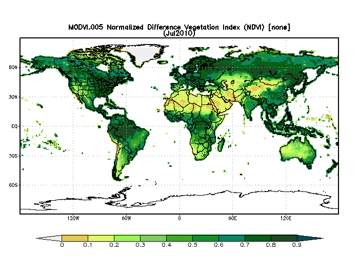
Federal
MODIS/Terra Monthly Vegetation Indices Global 1x1 degree V005 (MODVI) at GES DISC
National Aeronautics and Space Administration —
The global monthly gridded MODIS vegetation indices product is derived from the standard 0.05 CMG MODIS Terra Vegetation Indices Monthly product MOD13C2 (Huete et al,... -
Federal
MISR Level 3 Component Global Land Product covering a month subset for the UAE region V004
National Aeronautics and Space Administration —
UAEMRMLS_004 is the Multi-angle Imaging SpectroRadiometer (MISR) Level 3 Component Global Land Product covering a month subset for the UAE region version 4. It... -
Federal
MISR Level 3 Component Global Land Product covering a year V004
National Aeronautics and Space Administration —
MIL3YLS_4 is the Multi-angle Imaging SpectroRadiometer (MISR) Level 3 Component Global Land Product covering a year version 4. It contains a statistical summary of...

Official websites use .gov
A
.gov website belongs to an official government
organization in the United States.
Secure .gov websites use HTTPS
A
lock (
) or https:// means you’ve safely connected to
the .gov website. Share sensitive information only on official,
secure websites.