
-
Federal
Delaware River and Upper Bay Sediment Data
National Oceanic and Atmospheric Administration, Department of Commerce —
The area of coverage consists of 192 square miles of benthic habitat mapped from 2005 to 2007 in the Delaware River and Upper Delaware Bay. The bottom sediment map... -
Federal
Delaware Bay Upper Shelf Bottom Sediments 2008-2010
National Oceanic and Atmospheric Administration, Department of Commerce —
The Coastal Program of Delaware's Division of Soil and Water conservation (DNREC), the University of Delaware, Partnership for the Delaware Estuary, and the New... -
Federal
H12151: NOS Hydrographic Survey , Delaware River, Pennsylvania and New Jersey, 2009-12-09
National Oceanic and Atmospheric Administration, Department of Commerce —
The National Oceanic and Atmospheric Administration (NOAA) has the statutory mandate to collect hydrographic data in support of nautical chart compilation for safe... -
Federal
Shoreline Data Rescue Project of Delaware River, PA, MD133C01 NGDA
National Oceanic and Atmospheric Administration, Department of Commerce —
These data were automated to provide an accurate high-resolution historical shoreline of Delaware River, PA suitable as a geographic information system (GIS) data... -
Federal
H12148: NOS Hydrographic Survey , Delaware River, Pennsylvania and New Jersey, 2009-12-09
National Oceanic and Atmospheric Administration, Department of Commerce —
The National Oceanic and Atmospheric Administration (NOAA) has the statutory mandate to collect hydrographic data in support of nautical chart compilation for safe... -
Federal
Delaware Bay, Delaware Benthic Habitats 2010 Geoform
National Oceanic and Atmospheric Administration, Department of Commerce —
The Coastal Program of Delaware's Division of Soil and Water conservation (DNREC), the University of Delaware, Partnership for the Delaware Estuary, and the New... -
Federal
Delaware Bay, Delaware Sediment Distribution 2003 to 2004
National Oceanic and Atmospheric Administration, Department of Commerce —
The area of coverage consists of 38 square miles of benthic habitat mapped from 2003 to 2004 along the middle to lower Delaware Bay Coast. The bottom sediment map was... -
Federal
H10200: NOS Hydrographic Survey , Delaware Bay, 1986-06-12
National Oceanic and Atmospheric Administration, Department of Commerce —
The National Oceanic and Atmospheric Administration (NOAA) has the statutory mandate to collect hydrographic data in support of nautical chart compilation for safe... -
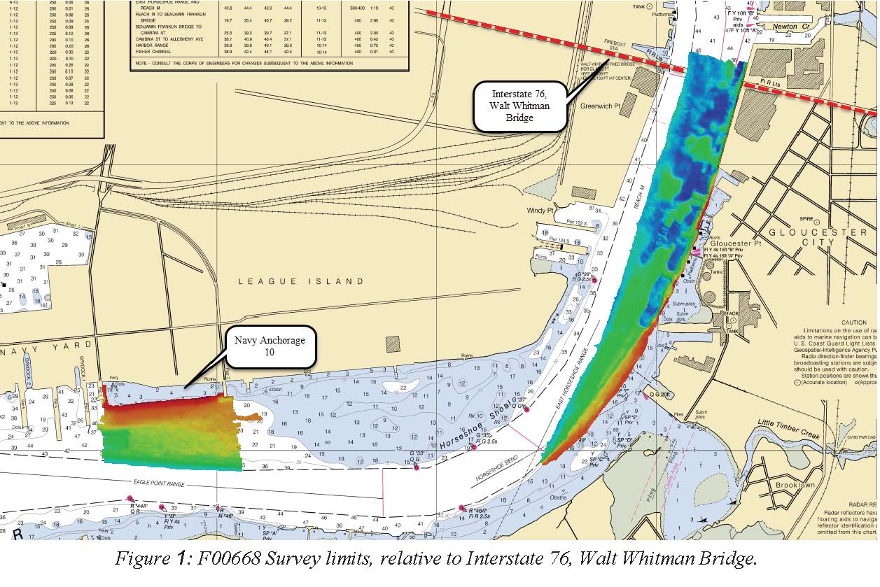
Federal
F00668: NOS Hydrographic Survey , 2015-10-22
National Oceanic and Atmospheric Administration, Department of Commerce —
The National Oceanic and Atmospheric Administration (NOAA) has the statutory mandate to collect hydrographic data in support of nautical chart compilation for safe... -
Federal
Shoreline Mapping Program of DELAWARE RIVER, PHILADELPHIA TO TRENTON, NJ0301B NGDA
National Oceanic and Atmospheric Administration, Department of Commerce —
These data provide an accurate high-resolution shoreline compiled from imagery of DELAWARE RIVER, PHILADELPHIA TO TRENTON . This vector shoreline data is based on an... -
Federal
Shoreline Mapping Program of DELAWARE RIVER, LISTON POINT TO NEW CASTLE, NJ0301E NGDA
National Oceanic and Atmospheric Administration, Department of Commerce —
These data provide an accurate high-resolution shoreline compiled from imagery of DELAWARE RIVER, LISTON POINT TO NEW CASTLE . This vector shoreline data is based on... -
Federal
H10092: NOS Hydrographic Survey , Delaware River, Delaware and New Jersey, 1983-10-05
National Oceanic and Atmospheric Administration, Department of Commerce —
The National Oceanic and Atmospheric Administration (NOAA) has the statutory mandate to collect hydrographic data in support of nautical chart compilation for safe... -
Federal
H00141A: NOS Hydrographic Survey , 1843-11-28
National Oceanic and Atmospheric Administration, Department of Commerce —
The National Oceanic and Atmospheric Administration (NOAA) has the statutory mandate to collect hydrographic data in support of nautical chart compilation for safe... -
Federal
Delaware / New Jersey / Pennsylvania 2014 ESI Polygons
National Oceanic and Atmospheric Administration, Department of Commerce —
The ESIP data set contains vector polygons representing the shoreline and coastal habitats of Delaware/New Jersey/Pennsylvania classified according to the... -
Federal
Shoreline Data Rescue Project of Delaware River, PA, EC7E06 NGDA
National Oceanic and Atmospheric Administration, Department of Commerce —
These data were automated to provide an accurate high-resolution historical shoreline of Delaware River, PA suitable as a geographic information system (GIS) data... -
Federal
Delaware Bay, Delaware Benthic Habitats 2010 Biotic
National Oceanic and Atmospheric Administration, Department of Commerce —
The Coastal Program of Delaware's Division of Soil and Water conservation (DNREC), the University of Delaware, Partnership for the Delaware Estuary, and the New... -
Federal
Delaware / New Jersey / Pennsylvania 2014 ESI BENTHIC Polygons
National Oceanic and Atmospheric Administration, Department of Commerce —
This data set contains sensitive biological resource data for submerged aquatic vegetation for Delaware/New Jersey/Pennsylvania. Vector polygons in this data set... -
Federal
Shoreline Data Rescue Project of Delaware River, Northeast of Philadelphia, Pennsylvania, EC8B01 NGDA
National Oceanic and Atmospheric Administration, Department of Commerce —
These data were automated to provide an accurate high-resolution historical shoreline of Delaware River, Northeast of Philadelphia, Pennsylvania suitable as a... -
Federal
Shoreline Data Rescue Project of Delaware River, NJ, EC7E05 NGDA
National Oceanic and Atmospheric Administration, Department of Commerce —
These data were automated to provide an accurate high-resolution historical shoreline of Delaware River, NJ suitable as a geographic information system (GIS) data... -
Federal
H00142: NOS Hydrographic Survey , 1843-12-21
National Oceanic and Atmospheric Administration, Department of Commerce —
The National Oceanic and Atmospheric Administration (NOAA) has the statutory mandate to collect hydrographic data in support of nautical chart compilation for safe...

Official websites use .gov
A
.gov website belongs to an official government
organization in the United States.
Secure .gov websites use HTTPS
A
lock (
) or https:// means you’ve safely connected to
the .gov website. Share sensitive information only on official,
secure websites.
.jpg)
.jpg)
.jpg)