

10 datasets found
-
Federal
Sea level measured by tide gauges from global oceans as part of the Joint Archive for Sea Level (JASL) since 1846
National Oceanic and Atmospheric Administration, Department of Commerce —
This collection contains the complete holdings of the Joint Archive for Sea Level (JASL) for hourly and daily data that have been quality controlled, assessed, and... -
Federal
Dauphin Island, Alabama: elevation change and beach background oiling from 2018-03-08 to 2018-12-06 (NCEI Accession 0187809)
National Oceanic and Atmospheric Administration, Department of Commerce —
Raw data in the form of observations, measurements, GPS coordinates, and photographs were generated during every elevation survey. Beach surveys resulted in elevation... -
Federal
Biological, chemical, and physical data from the Phytoplankton Monitoring Network from 2001-09-13 to 2013-03-07 (NCEI Accession 0117942)
National Oceanic and Atmospheric Administration, Department of Commerce —
The Phytoplankton Monitoring Network (PMN) is a part of the National Centers for Coastal Ocean Science (NCCOS). The PMN was created as an outreach program to connect... -
Federal
Alabama Near Coastal Meteorological & Hydrographic Continuous Data Sampling from 2003 to present
National Oceanic and Atmospheric Administration, Department of Commerce —
The Alabama Real-time Coastal Observing System (ARCOS) with support of the Dauphin Island Sea Lab is a network of continuously sampling observing stations that... -
Federal
Oceanographic data collected from non-federal stations assembled by the Gulf of America Coastal Ocean Observing System (GCOOS)
National Oceanic and Atmospheric Administration, Department of Commerce —
This dataset contains oceanographic and surface meteorological data collected from non-Federal stations throughout the Gulf of America region of the United States.... -
Federal
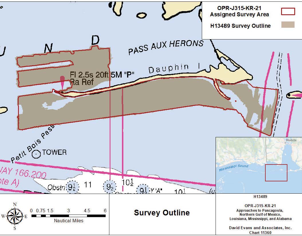
H13489: NOS Hydrographic Survey , 2021-11-17
National Oceanic and Atmospheric Administration, Department of Commerce —
The National Oceanic and Atmospheric Administration (NOAA) has the statutory mandate to collect hydrographic data in support of nautical chart compilation for safe... -
Federal
Shoreline Data Rescue Project of Dauphin Island, AL, AL1954B NGDA
National Oceanic and Atmospheric Administration, Department of Commerce —
These data were automated to provide an accurate high-resolution historical shoreline of Dauphin Island, AL suitable as a geographic information system (GIS) data... -
Federal
Hurricane Katrina Aerial Photography: High-Resolution Imagery of the Gulf Coast of Louisiana, Mississippi and Alabama After Landfall
National Oceanic and Atmospheric Administration, Department of Commerce —
The imagery posted on this site is of the Gulf Coast of Louisiana, Mississippi and Alabama after Hurricane Katrina made landfall. The regions photographed range from... -
Federal
Coastal Mapping Program of Dauphin Island, AL, MS2302A-CM-N NGDA
National Oceanic and Atmospheric Administration, Department of Commerce —
These data provide an accurate high-resolution shoreline compiled from imagery of Dauphin Island, AL . This vector shoreline data is based on an office interpretation... -
Federal
Shoreline Mapping Program of DAUPHIN ISLAND, AL, AL1102 NGDA
National Oceanic and Atmospheric Administration, Department of Commerce —
These data provide an accurate high-resolution shoreline compiled from imagery of DAUPHIN ISLAND, AL . This vector shoreline data is based on an office interpretation...
10 datasets found