
-
Federal
MODIS/Terra+Aqua BRDF Model Parameters Daily L3 Global 1km SIN Grid V061 NGDA
National Aeronautics and Space Administration —
The MCD19A3D Version 6.1 data product is a Moderate Resolution Imaging Spectroradiometer (MODIS) Terra and Aqua combined Bidirectional Reflectance Distribution... -
Federal
Randolph Glacier Inventory - A Dataset of Global Glacier Outlines, Version 4 NGDA
National Aeronautics and Space Administration —
The Randolph Glacier Inventory (RGI) is a global set of glacier outlines; it is intended as a snapshot of the world’s glaciers. This data set provides a single... -
Federal
ISLSCP II Global Sea Ice Concentration
National Aeronautics and Space Administration —
This International Satellite Land Surface Climatology Project (ISLSCP) Initiative II data set, ISLSCP II Global Sea Ice Concentration, is based on the Goddard Space... -
Federal
Randolph Glacier Inventory - A Dataset of Global Glacier Outlines, Version 3 NGDA
National Aeronautics and Space Administration —
The Randolph Glacier Inventory (RGI) is a global set of glacier outlines; it is intended as a snapshot of the world’s glaciers. This data set provides a single... -
Federal
Randolph Glacier Inventory - A Dataset of Global Glacier Outlines, Version 2 NGDA
National Aeronautics and Space Administration —
The Randolph Glacier Inventory (RGI) is a global set of glacier outlines; it is intended as a snapshot of the world’s glaciers. This data set provides a single... -
Federal
ABoVE: Last Day of Spring Snow, Alaska, USA, and Yukon Territory, Canada, 2000-2016 NGDA
National Aeronautics and Space Administration —
This dataset provides the last day of spring snow cover for most of Alaska and the Yukon Territory for 2000 through 2016. The data are based on the MODIS daily snow... -
Federal
ABoVE: Passive Microwave-derived Annual Snowoff Date Maps, 1988-2018
National Aeronautics and Space Administration —
This dataset provides annual maps of the snowoff (SO) date from 1988-2018 across Alaska and parts of Far East Russia and northwest Canada at a resolution of 6.25 km.... -
Federal
Alaska's Changing YK Delta: Knowledge Exchange between Elders and Geoscientists, 2018
National Aeronautics and Space Administration —
This dataset provides a booklet documenting the discussions and outcomes from a knowledge-exchange meeting with Yup'ik elders from the Yukon-Kuskokwim Delta (YKD),... -
Federal
Arctic Vegetation Plots in Willow Communities, North Slope, Alaska, 1997
National Aeronautics and Space Administration —
This data set provides environmental, soil, and vegetation data collected in July and August 1997 from 85 study plots in willow shrub communities located along a... -
Federal
CARVE: Daily Thaw State of Boreal and Arctic Alaska from AMSR-E and SSM/I, 2003-2014
National Aeronautics and Space Administration —
This data set provides daily 10 km resolution maps of the Alaskan and Arctic Boreal land surface state as either frozen, melting, or thawed. These data are generated... -
Federal
Randolph Glacier Inventory - A Dataset of Global Glacier Outlines, Version 1 NGDA
National Aeronautics and Space Administration —
The Randolph Glacier Inventory (RGI) is a global set of glacier outlines; it is intended as a snapshot of the world’s glaciers. This data set provides a single... -
Federal
Randolph Glacier Inventory - A Dataset of Global Glacier Outlines, Version 5 NGDA
National Aeronautics and Space Administration —
The Randolph Glacier Inventory (RGI) is a global set of glacier outlines; it is intended as a snapshot of the world’s glaciers. This data set provides a single... -
Federal
Randolph Glacier Inventory - A Dataset of Global Glacier Outlines, Version 6 NGDA
National Aeronautics and Space Administration —
The Randolph Glacier Inventory (RGI) is a global set of glacier outlines; it is intended as a snapshot of the world’s glaciers. This data set provides a single... -
Federal
IceBridge ATM L2 Icessn Elevation, Slope, and Roughness V002
National Aeronautics and Space Administration —
This data set contains resampled and smoothed elevation measurements of Arctic and Antarctic sea ice, and Greenland, Antarctic Peninsula, and West Antarctic region... -
Federal
ABoVE: Passive Microwave-derived Annual Snowpack Main Melt Onset Date Maps, 1988-2018
National Aeronautics and Space Administration —
This dataset provides the annual date of snowpack seasonal beginning melt (i.e., main melt onset date, MMOD) across northwest Canada; Alaska, U.S.; and parts of far... -
Federal
ICESat-2 L4 Monthly Gridded Sea Ice Thickness V003
National Aeronautics and Space Administration —
This data set reports monthly, gridded winter sea ice thickness across the Arctic Ocean. Sea ice thickness is estimated using ATLAS/ICESat-2 L3A Sea Ice Freeboard... -
Federal
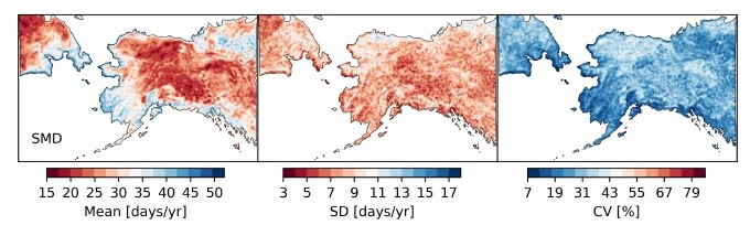
ABoVE: Passive Microwave-derived Annual Snow Melt Duration Date Maps, 1988-2018
National Aeronautics and Space Administration —
This dataset provides the annual period of snowpack melting (i.e., snow melt duration, SMD) across northwest Canada; Alaska, U.S.; and parts of far eastern Russia at... -
Federal
Randolph Glacier Inventory - A Dataset of Global Glacier Outlines, Version 7 NGDA
National Aeronautics and Space Administration —
The Randolph Glacier Inventory (RGI) is a global set of glacier outlines intended as a snapshot of the world’s glaciers outside of ice sheets. It provides a single... -
Federal
MEaSUREs Greenland Monthly Image Mosaics from MODIS V001 NGDA
National Aeronautics and Space Administration —
This data set, part of the NASA Making Earth System Data Records for Use in Research Environments (MEaSUREs) program, consists of monthly image mosaics of the...

Official websites use .gov
A
.gov website belongs to an official government
organization in the United States.
Secure .gov websites use HTTPS
A
lock (
) or https:// means you’ve safely connected to
the .gov website. Share sensitive information only on official,
secure websites.