

18 datasets found
-
Federal
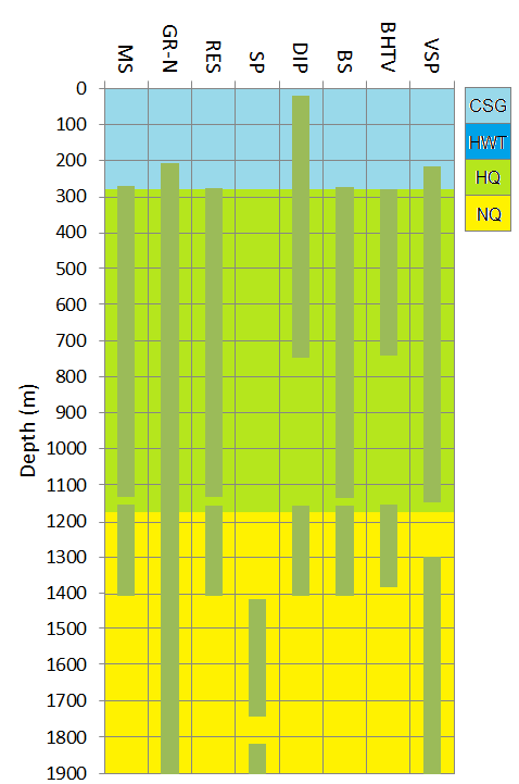
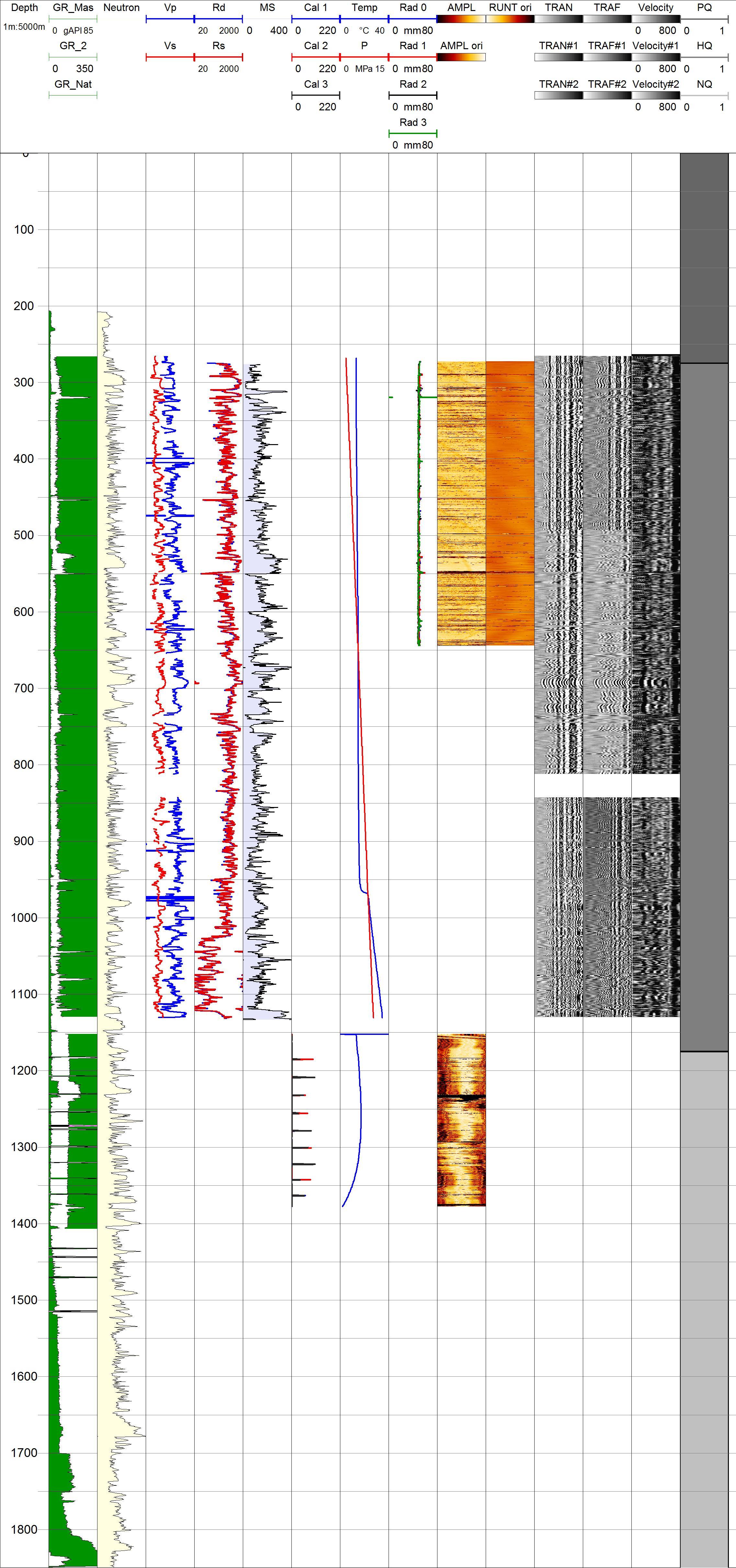
Project HOTSPOT: Mountain Home Well Borehole Geophysics Database
Department of Energy —
The Snake River Plain (SRP), Idaho, hosts potential geothermal resources due to elevated groundwater temperatures associated with the thermal anomaly Yellowstone-... -
Federal
Project HOTSPOT: Kimberly Well Borehole Geophysics Database
Department of Energy —
The Snake River Plain (SRP), Idaho, hosts potential geothermal resources due to elevated groundwater temperatures associated with the thermal anomaly Yellowstone-... -
Federal
Project Hotspot - Petrology, Geochemistry and Stratigraphy of the Kimama core hole, Snake River Plain, Idaho
Department of Energy —
This submission contains links to two open source published papers on the Kimama core hole, Project Hotspot. "Volcanic stratigraphy and age model of the Kimama deep... -
Federal
Project HOTSPOT: Kimberly Well Core Photos
Department of Energy —
The Snake River Plain (SRP), Idaho, hosts potential geothermal resources due to elevated groundwater temperatures associated with the thermal anomaly Yellowstone-... -
Federal
Geochemical and geophysical data for wells in the Fruitvale and Rosedale Ranch oil and gas fields, Kern County, California, USA
Department of the Interior —
The U.S. Geological Survey (USGS) in cooperation with the California State Water Resources Control Board compiled and analyzed data for the purpose of mapping... -
Federal
Geochemical and geophysical data for wells in the Rosedale Ranch oil and gas field
Department of the Interior —
The U.S. Geological Survey (USGS) in cooperation with the California State Water Resources Control Board compiled and analyzed data for the purpose of mapping... -
Federal
Project HOTSPOT: Kimama Well Core and Drill Site Photos
Department of Energy —
The Snake River Plain (SRP), Idaho, hosts potential geothermal resources due to elevated groundwater temperatures associated with the thermal anomaly Yellowstone-... -
Federal
Project HOTSPOT: Mountain Home Well Core and Drill Site Photos
Department of Energy —
The Snake River Plain (SRP), Idaho, hosts potential geothermal resources due to elevated groundwater temperatures associated with the thermal anomaly Yellowstone-... -
Federal
Geophysical and geochemical data for salinity mapping in the Midway-Sunset oil field area
Department of the Interior —
The U.S. Geological Survey (USGS) and California State University-Sacramento, in cooperation with the California State Water Resources Control Board and U.S. Bureau... -
Federal
Project HOTSPOT: Kimama Well Borehole Geophysics Database
Department of Energy —
The Snake River Plain (SRP), Idaho, hosts potential geothermal resources due to elevated groundwater temperatures associated with the thermal anomaly Yellowstone-... -
Federal
Geophysical and geological data for select petroleum wells in North Coles Levee Oil Field, Kern County, California
Department of the Interior —
This dataset includes geological and geophysical data from petroleum wells located in the North Coles Levee Oil Field, Kern County, California. The purpose of this... -
Federal
Geophysical, geological, hydrological, and geochemical data for aquifer salinity mapping in the Elk Hills, Buena Vista, and Coles Levee Oil Fields, Kern County, California
Department of the Interior —
The U.S. Geological Survey (USGS) in cooperation with the California State Water Resources Control Board (State Water Board) compiled and analyzed data for mapping... -
Federal
Datasets Used to Create Maps of Pierre Shale Elevation and Surficial Deposit Thickness within and near Ellsworth Air Force Base, South Dakota, 2021
Department of the Interior —
The U.S. Geological Survey, in cooperation with the U.S. Air Force Civil Engineering Center, collected borehole geophysical data and performed simple aquifer tests to... -
Federal
Geochemical and geophysical data for wells in the Fruitvale oil and gas field
Department of the Interior —
The U.S. Geological Survey (USGS) in cooperation with the California State Water Resources Control Board compiled and analyzed data for the purpose of mapping... -
Federal
Geochemical and geophysical data for selected wells in and surrounding the South Cuyama oil and gas field
Department of the Interior —
The U.S. Geological Survey (USGS) in cooperation with the California State Water Resources Control Board and Bureau of Land Management compiled and analyzed data for... -
Federal
Geological, geochemical, and geophysical data from the Lost Hills and Belridge oil fields (ver. 3.0, June 2022)
Department of the Interior —
The U.S. Geological Survey (USGS) in cooperation with the California State Water Resources Control Board compiled and analyzed data for mapping groundwater salinity... -
Federal
Geochemical, geological, and geophysical data for wells in the Poso Creek Oil Field area, Kern County, California (ver. 2.0, September 2021)
Department of the Interior —
The U.S. Geological Survey (USGS) in cooperation with the California State Water Resources Control Board and the U.S. Bureau of Land Management compiled and analyzed... -
Federal
Data Used to Assess the Hydrogeologic Framework with Emphasis on the Ogallala and Edwards-Trinity Aquifers, in and Near Gaines, Terry, and Yoakum Counties, Texas, 2018
Department of the Interior —
More than 11,500 well records, such as geophysical logs, drilling descriptions, and published hydrogeologic framework information, were evaluated to help characterize...
18 datasets found