
-
Federal
Benthic habitat data of Wawaloi and Keei, Kona Coast, Island of Hawaii, August 2004 (NODC Accession 0070530)
National Oceanic and Atmospheric Administration, Department of Commerce —
Transects were made at two locations on the west side of the Island of Hawaii in August 2004 to study the structure and composition of the benthic habitat.... -
Federal
Sediment Profile Image Data from September 2001 in Wells, Maine (wellsspi)
National Oceanic and Atmospheric Administration, Department of Commerce —
In fall 2001, researchers from the Wells National Estuarine Research Reserve, Virginia Institute of Marine Science, and the NOAA Office for Coastal Management... -
Federal
Benthic data, fish surveys and still images from Hawaii Coral Reef Assessment and Monitoring Program (CRAMP) starting 1999-01-05 to present
National Oceanic and Atmospheric Administration, Department of Commerce —
This collection consists of Hawaii Coral Reef Assessment and Monitoring Program (CRAMP) surveys and include quantitative estimates of substrate type, rugosity,... -
Federal
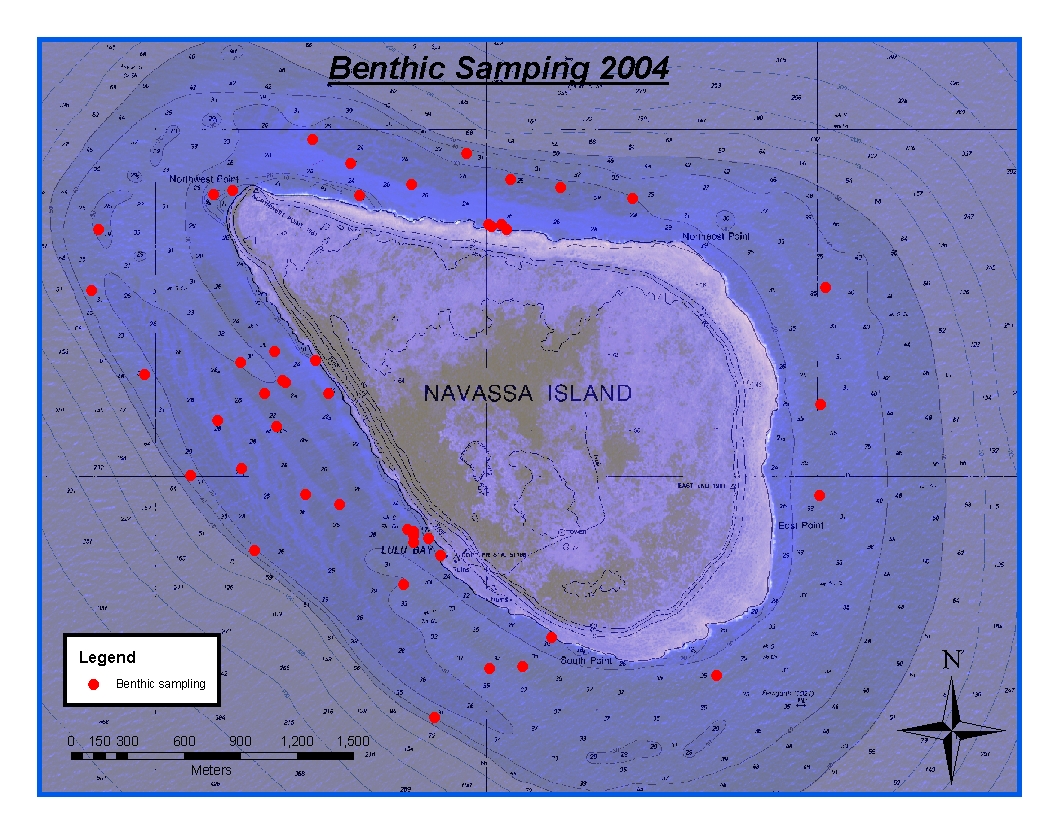
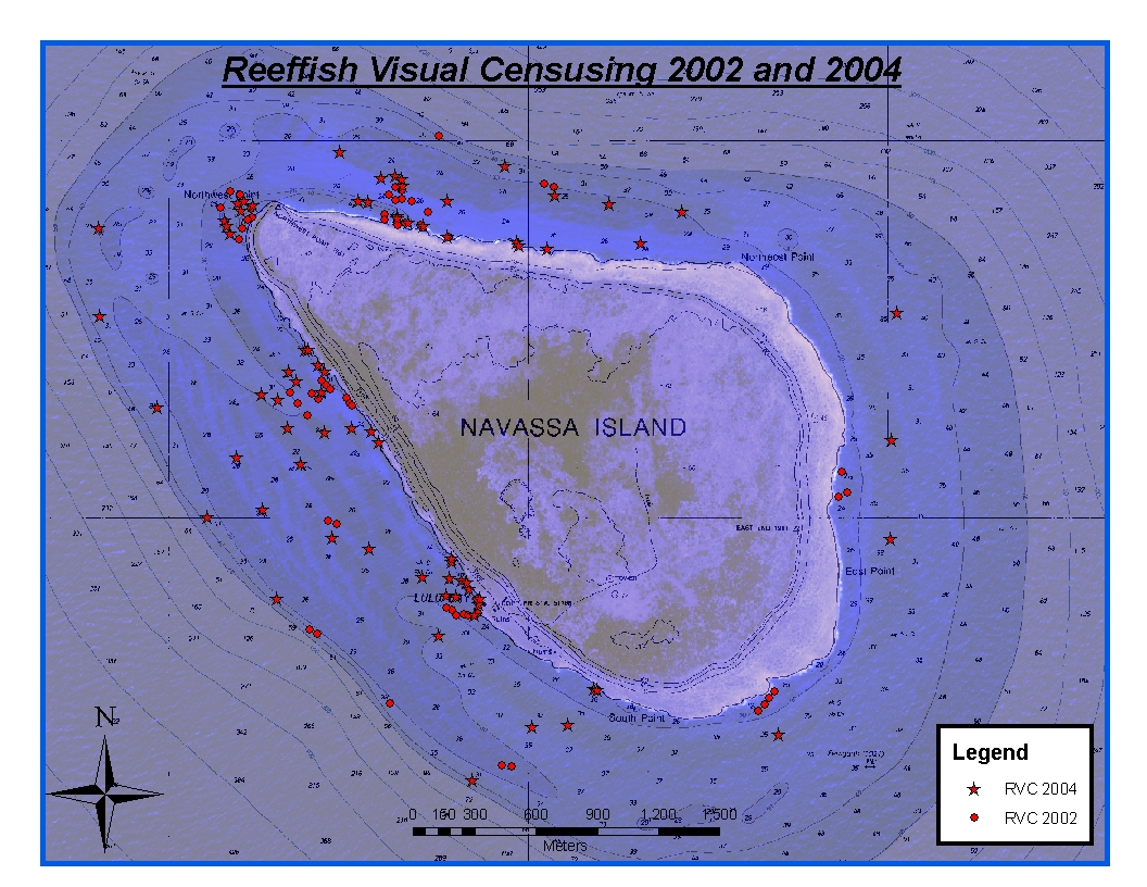
CRCP-Navassa reef assessment
National Oceanic and Atmospheric Administration, Department of Commerce —
Episodic cruises ( every 2 years) were conducted to perform assessments of Navassa Island coral reef resources including reeffish visual census, benthic reef... -
Federal
2002 Long Island South Shore Estuary Benthic Habitat Polygon Data Set Geodatabase
National Oceanic and Atmospheric Administration, Department of Commerce —
In June 2002, 200 1:20,000 scale conventional-color metric film diapositives for Long Island, New York were collected as part of an effort to map submerged aquatic... -
Federal
2002 Long Island South Shore Estuary Benthic Habitat Polygon Data Set Biotic
National Oceanic and Atmospheric Administration, Department of Commerce —
In June 2002, 200 1:20,000 scale conventional-color metric film diapositives for Long Island, New York were collected as part of an effort to map submerged aquatic... -
Federal
NOAA Office for Coastal Management Benthic Habitat Data, Catlett and Goodwin Islands on the York River in Chesapeake Bay, VA, 2002-2004 (NCEI Accession 0090253)
National Oceanic and Atmospheric Administration, Department of Commerce —
These data are a collection of benthic habitat data from studies conducted in the Catlett and Goodwin Islands on the York River in Chesapeake Bay, Virginia in GIS... -
Federal
Delta-15 Nitrogen values from all shores of Maui and benthic, algae, and urchin data from Kahekili, West Maui, 2007-2009 (NCEI Accession 0068665)
National Oceanic and Atmospheric Administration, Department of Commerce —
The Hawaii Division of Aquatic Resources (DAR) established an Herbivore Fisheries Management Area (HFMA) in front of Kahekili Beach Park in West Maui that was... -
Federal
Hawaii Coral Reef Assessment and Monitoring Program (CRAMP): benthic data from digital still images made in 2008-2010 on Kauai, Oahu, Molokai, Maui, and Hawaii (NODC Accession 0104255)
National Oceanic and Atmospheric Administration, Department of Commerce —
This dataset consists of benthic data from the Hawaii Coral Reef Assessment and Monitoring Program (CRAMP) taken 2008-2010 from 24 sites on within 5 main Hawaiian... -
Federal
Sediment profile image data from October 1999 in Apalachicola Bay, Florida
National Oceanic and Atmospheric Administration, Department of Commerce —
The Apalachicola Bay National Estuarine Research Reserve and the NOAA Office for Coastal Management worked together to map benthic habitats within Apalachicola Bay,... -
Federal
2002 Long Island South Shore Estuary Benthic Habitat Polygon Data Set Geoform
National Oceanic and Atmospheric Administration, Department of Commerce —
In June 2002, 200 1:20,000 scale conventional-color metric film diapositives for Long Island, New York were collected as part of an effort to map submerged aquatic... -
Federal
2002 Long Island South Shore Estuary Benthic Habitat Polygon Data Set Substrate
National Oceanic and Atmospheric Administration, Department of Commerce —
In June 2002, 200 1:20,000 scale conventional-color metric film diapositives for Long Island, New York were collected as part of an effort to map submerged aquatic... -
Federal
NOAA Office for Coastal Management Benthic Habitat Data, Apalachicola Bay, Dry Tortugas, Florida Bay, and Indian River Lagoon, Florida, 1991-2001 (NCEI Accession 0001045)
National Oceanic and Atmospheric Administration, Department of Commerce —
These data are a collection of regional GIS (Arcview shapefiles and associated Federal Geographic Data Committee (FGDC) metadata) benthic habitat files from studies... -
Federal
NOAA Office for Coastal Management and Maine Department of Marine Resources Benthic Habitat Data, coastal Maine and York and Webhannet rivers, 1993-2001 (NCEI Accession 0089462)
National Oceanic and Atmospheric Administration, Department of Commerce —
Maine's eelgrass (SAV) meadows form an important aquatic habitat for the state. These meadows provide shelter for juvenile fish, and invertebrates. In certain... -
Federal
Benthic habitat data for Wawaloi and Keei, Kona Coast, Island of Hawaii, August 2004 (NCEI Accession 0070530)
National Oceanic and Atmospheric Administration, Department of Commerce —
Transects were made at two locations on the west side of the Island of Hawaii in August 2004 to study the structure and composition of the benthic habitat.... -
Federal
US Environmental Protection Agency National Coastal Assessment for American Samoa 2004: water quality, sediment grain, and chemistry data (NCEI Accession 0000455)
National Oceanic and Atmospheric Administration, Department of Commerce —
In 2004, the Environmental Protection Agency (EPA) Environmental Monitoring and Assessment Program (EMAP) National Coastal Assessment (NCA), coordinated through the... -
Federal
US Environmental Protection Agency National Coastal Assessment for Hawaii 2002: Water Quality, Fish Taxon, Sediment Chemistry Data (NCEI Accession 0061250)
National Oceanic and Atmospheric Administration, Department of Commerce —
In 2002, the Environmental Protection Agency (EPA) Environmental Monitoring and Assessment Program (EMAP) National Coastal Assessment (NCA), in conjunction with state... -
Federal
2004 Sediment Profile Imaging (SPI) Data for Catlett and Goodwin Islands on the York River, Chesapeake Bay, Virginia (Ches_2004SPI)
National Oceanic and Atmospheric Administration, Department of Commerce —
This data set represents the sediment profile imaging data from 2004 (79 stations).In Fall/Winter 2002, researchers from the Virginia Institute of Marine Science... -
Federal
US Environmental Protection Agency National Coastal Assessment for Hawaii 2002: Water Quality, Fish Taxon, Sediment Chemistry Data (NODC Accession 0061250)
National Oceanic and Atmospheric Administration, Department of Commerce —
In 2002, the Environmental Protection Agency (EPA) Environmental Monitoring and Assessment Program (EMAP) National Coastal Assessment (NCA), in conjunction with state...

Official websites use .gov
A
.gov website belongs to an official government
organization in the United States.
Secure .gov websites use HTTPS
A
lock (
) or https:// means you’ve safely connected to
the .gov website. Share sensitive information only on official,
secure websites.