
-
Federal
CALIPSO Lidar Level 2 Cloud Profile, V4-20 15 recent views
National Aeronautics and Space Administration —
CAL_LID_L2_05kmCPro-Standard-V4-20 is the Cloud-Aerosol Lidar and Infrared Pathfinder Satellite Observations (CALIPSO) Lidar Level 2 Cloud Profile, Version 4-20 data... -
Federal
NCEP/CPC L3 Half Hourly 4km Global (60S - 60N) Merged IR V1 (GPM_MERGIR) at GES DISC
National Aeronautics and Space Administration —
These data originate from NOAA/NCEP. The NOAA Climate Prediction Center/NCEP/NWS is making the data available originally in binary format, in a weekly rotating... -
Federal
CALIPSO Lidar Level 2 Aerosol Profile, V4-20
National Aeronautics and Space Administration —
CAL_LID_L2_05kmAPro-Standard-V4-20 is the Cloud-Aerosol Lidar and Infrared Pathfinder Satellite Observations (CALIPSO) Lidar Level 2 Aerosol Profile, Version 4-20... -
Federal
Aircraft Scanners
National Aeronautics and Space Administration —
The National Aeronautics and Space Administration (NASA) Aircraft Scanners data set contains digital imagery acquired from several multispectral scanners, including... -
Federal
CALIPSO Lidar Level 2 Vertical Feature Mask (VFM), V4-20
National Aeronautics and Space Administration —
CAL_LID_L2_VFM-Standard-V4-20 is the Cloud-Aerosol Lidar and Infrared Pathfinder Satellite Observations (CALIPSO) Lidar Level 2 Vertical Feature Mask (VFM), Version... -
Federal
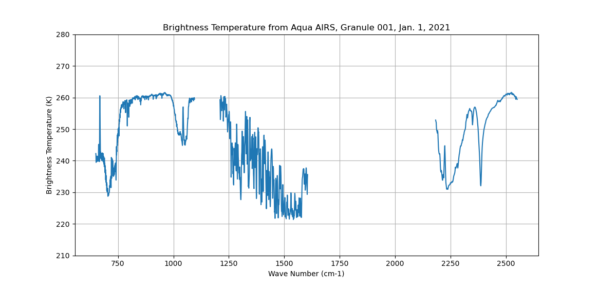
AIRS/Aqua L1B Infrared (IR) geolocated and calibrated radiances V005 (AIRIBRAD) at GES DISC at GES DISC
National Aeronautics and Space Administration —
WARNING: On 2021/09/23 the EOS Aqua executed a Deep Space Maneuver (DSM). In the DSM, the spacecraft is turned such that the normal Earth field of regard is deep... -
Federal
Sounder SIPS: Sun Synchronous 13:30 orbit Climate Hyperspectral InfraRed Product (CHIRP): Calibrated Radiances from EOS-Aqua, V2 (SNDR13CHRP1AQCal) at GES DISC
National Aeronautics and Space Administration —
The Climate Hyperspectral Infrared Radiance Product (CHIRP) is a Level 1 radiance product derived from Atmospheric Infrared Sounder (AIRS) on EOS-AQUA and the Cross-... -
Federal
AIRS/Aqua L1B Near Real Time (NRT) Infrared (IR) geolocated and calibrated radiances V005 (AIRIBRAD_NRT) at GES DISC
National Aeronautics and Space Administration —
WARNING: On 2021/09/23 the EOS Aqua executed a Deep Space Maneuver (DSM). In the DSM, the spacecraft is turned such that the normal Earth field of regard is deep... -
Federal
Inventory of Arctic Rain on Snow Events: Meteorological and Surface Conditions, Version 1
National Aeronautics and Space Administration —
This data set contains surface and upper air data from global atmospheric reanalysis, and passive microwave brightness temperatures for rain on snow events in the... -
Federal
SMAPVEX19-22 Massachusetts Vegetation Optical Depth V001
National Aeronautics and Space Administration —
As part of the SMAPVEX19-22 campaign, an L-band radiometer was deployed on top of a tower at Harvard Forest,Massachusetts, looking down at a stand of red oak forest.... -
Federal
First ISCCP Regional Experiment (FIRE) Atlantic Stratocumulus Transition Experiment (ASTEX) United Kingdom Meteorological Office (UKMO) C-130 Aircraft Data
National Aeronautics and Space Administration —
The First ISCCP Regional Experiments have been designed to improve data products and cloud/radiation parameterizations used in general circulation models (GCMs).... -
Federal
OCO-2 Level 1A collated, parsed, science or calibration data V11 (OCO2_L1aIn_Sample) at GES DISC
National Aeronautics and Space Administration —
Version 11 is the current version of the data set. Older versions will no longer be available and are superseded by Version 11. The Orbiting Carbon Observatory is the... -
Federal
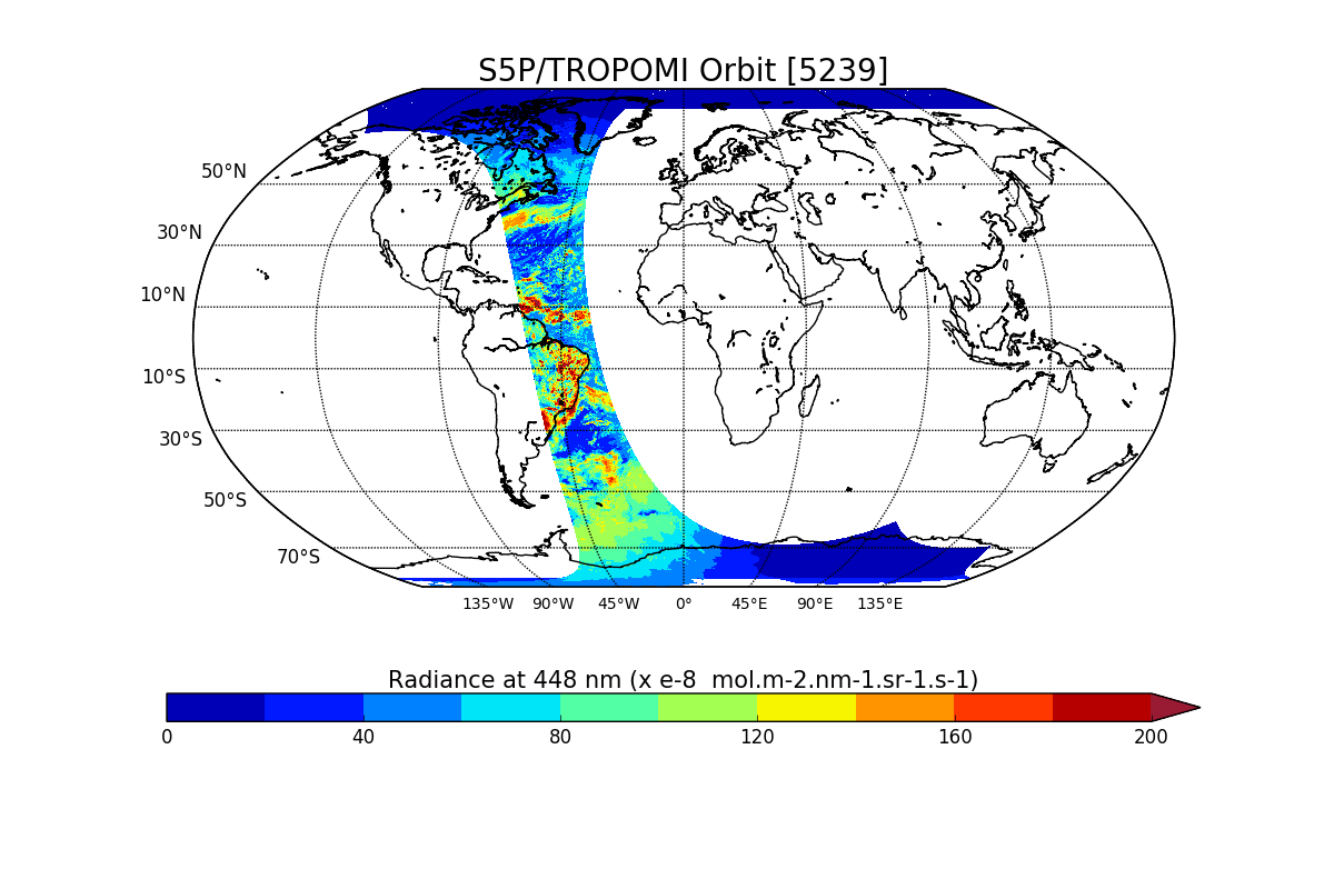
Sentinel-5P TROPOMI Radiance product band 4 (UVIS detector) L1B V1 (S5P_L1B_RA_BD4) at GES DISC
National Aeronautics and Space Administration —
Starting from August 6th in 2019, Sentinel-5P TROPOMI along-track high spatial resolution (~5.5km at nadir) has been implemented. For data after August 6th of 2019,... -
Federal
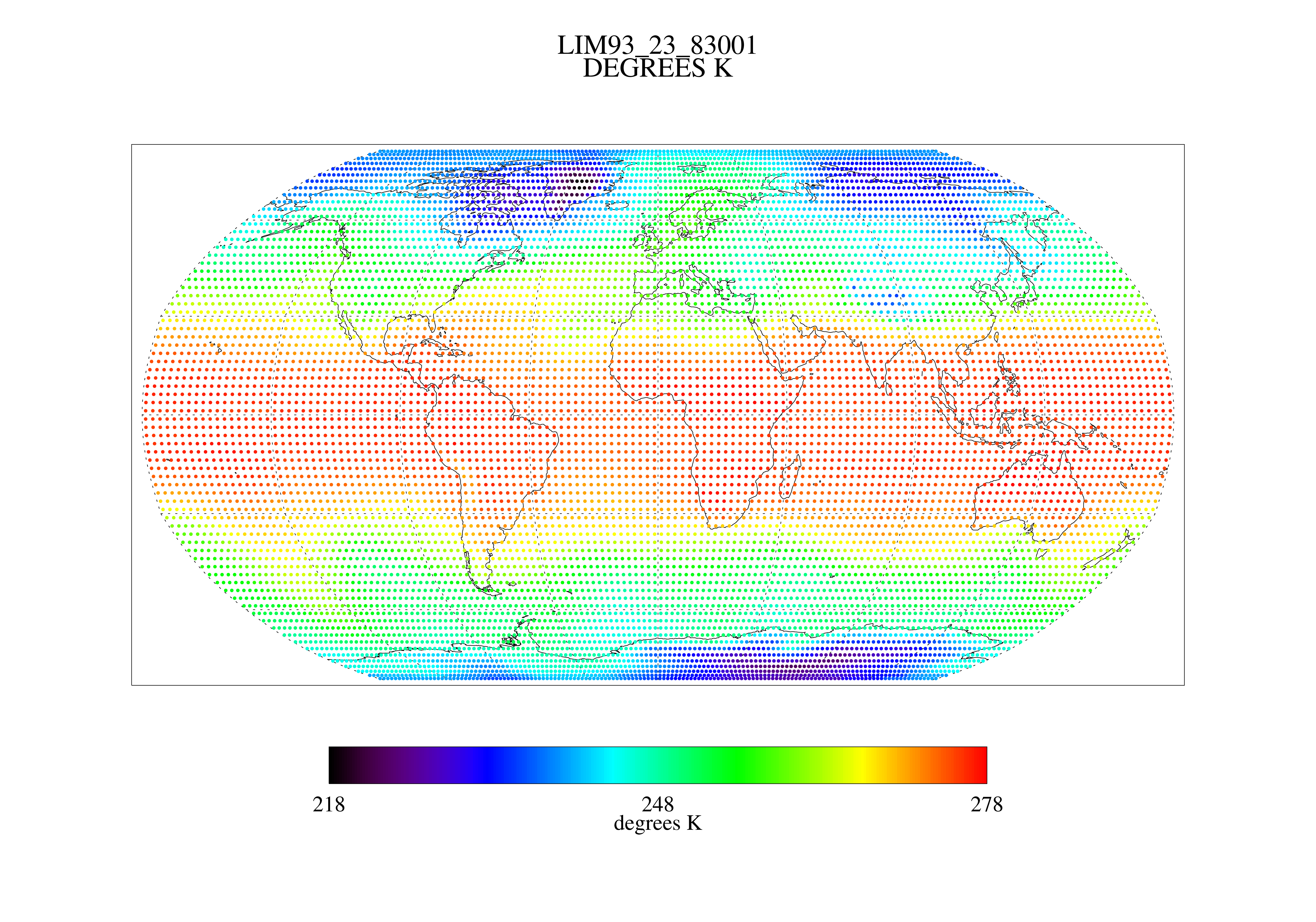
MSU Ch 2/3 Daily Lower Troposphere Temps with Limb93 Correction L3 1 day 2.5 degree x 2.5 degree V001 (MSULTT) at GES DISC
National Aeronautics and Space Administration —
The Microwave Sounding Unit (MSU) Lower Troposphere Deep Layer Temperature product (MSULTT) provides gridded lower tropospheric temperatures derived from MSU... -
Federal
Polar Winds II - Doppler Aerosol WiNd (DAWN) - DC8
National Aeronautics and Space Administration —
PolarWindsII_DAWN_DC8_1 is the Polar Winds II - Doppler Aerosol WiNd (DAWN) - DC8 data product. Data collection for this product is complete. Beginning in the fall of... -
Federal
First ISCCP Regional Experiment (FIRE) Cirrus 1 Colorado State University Sabreliner Aircraft Radiometric and Meteorological Data
National Aeronautics and Space Administration —
This data set contains meteorological and radiometeric data from the NCAR Sabreliner aircraft that was collected during the 1986 FIRE Cirrus IFO. The NCAR Sabreliner... -
Federal
GPM GROUND VALIDATION NASA MICRO RAIN RADAR (MRR) MC3E V1
National Aeronautics and Space Administration —
The GPM Ground Validation NASA Micro Rain Radar (MRR) MC3E dataset was collected by a Micro Rain Radar (MRR), which is a vertically pointing Doppler radar which... -
Federal
Sentinel-5P TROPOMI Radiance product band 2 (UV detector) L1B V1 (S5P_L1B_RA_BD2) at GES DISC
National Aeronautics and Space Administration —
Starting from August 6th in 2019, Sentinel-5P TROPOMI along-track high spatial resolution (~5.5km at nadir) has been implemented. For data after August 6th of 2019,... -
Federal
Sentinel-5P TROPOMI Radiance product band 8 (SWIR detector) L1B 5.5km x 7km V2 (S5P_L1B_RA_BD8_HiR) at GES DISC
National Aeronautics and Space Administration —
Starting from August 6th in 2019, Sentinel-5P TROPOMI along-track high spatial resolution (~5.5km at nadir) has been implemented. For data before August 6th of 2019,...

Official websites use .gov
A
.gov website belongs to an official government
organization in the United States.
Secure .gov websites use HTTPS
A
lock (
) or https:// means you’ve safely connected to
the .gov website. Share sensitive information only on official,
secure websites.