
-
Federal
Carbon Monitoring System Carbon Flux FossilFuel Prior L4 V3 (CMSFluxFossilFuelPrior)
National Aeronautics and Space Administration —
This dataset provides the Prior for the Fossil Fuel Carbon Flux. The NASA Carbon Monitoring System (CMS) is designed to make significant contributions in... -
Federal
Carbon Monitoring System Carbon Flux Total Prior L4 V3 (CMSFluxTotalPrior)
National Aeronautics and Space Administration —
This dataset provides the Prior for Total Carbon Flux. The NASA Carbon Monitoring System (CMS) is designed to make significant contributions in characterizing,... -
Federal
NOAA-20 VIIRS Regional Ocean Color (OC) Data, version R2022.0
National Aeronautics and Space Administration —
The Visible and Infrared Imager/Radiometer Suite (VIIRS) is a multi-disciplinary instrument that is being flown on the Joint Polar Satellite System (JPSS) series of... -
Federal
NOAA-20 VIIRS Regional Ocean Color (OC) - Near Real Time (NRT) Data, version R2022.0
National Aeronautics and Space Administration —
The Ocean Biology DAAC produces near real-time (quicklook) products using the best-available combination of ancillary data from meteorological and ozone data. As... -
Federal
SCOAPE R/V Point Sur Data
National Aeronautics and Space Administration —
SCOAPE_RVPointSur_Data is the data collected from instruments onboard the University of Southern Mississippi’s Research Vessel (R/V) Point Sur during the Satellite... -
Federal
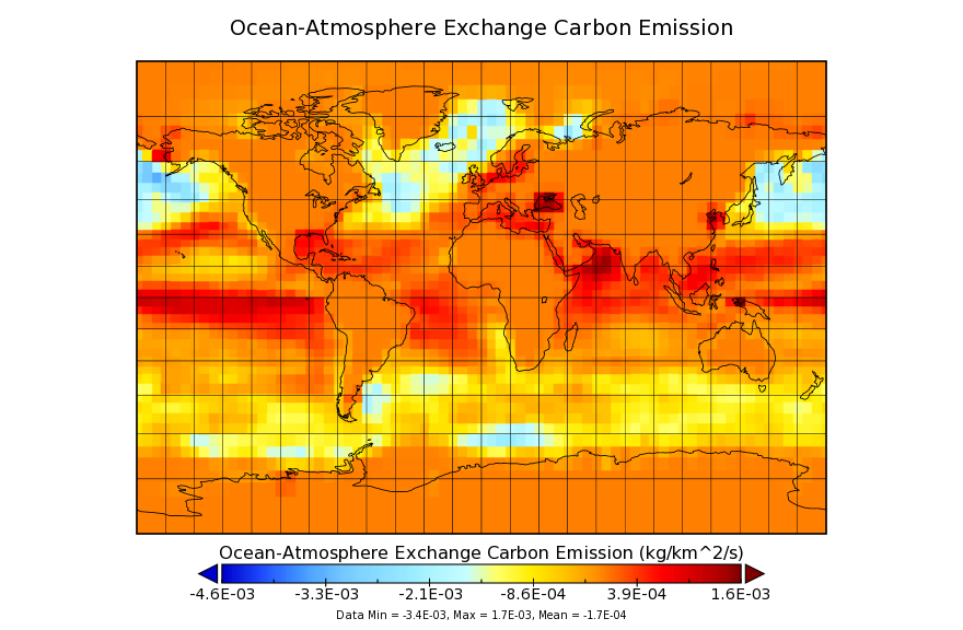
Carbon Monitoring System Flux for Ocean Carbon L4 V1 (CMSFluxOcean) at GES DISC
National Aeronautics and Space Administration —
This dataset provides the Carbon Flux for Ocean Carbon. The NASA Carbon Monitoring System (CMS) is designed to make significant contributions in characterizing,... -
Federal
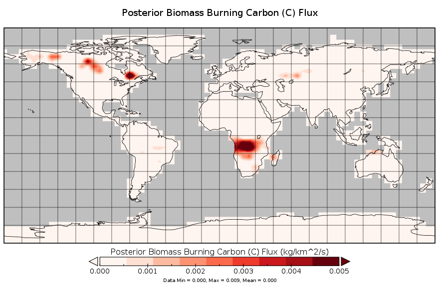
Carbon Monitoring System Carbon Flux for Fire L4 V2 (CMSFluxFire) at GES DISC
National Aeronautics and Space Administration —
This dataset provides the Carbon Flux for Fires. The NASA Carbon Monitoring System (CMS) is designed to make significant contributions in characterizing, quantifying,... -
Federal
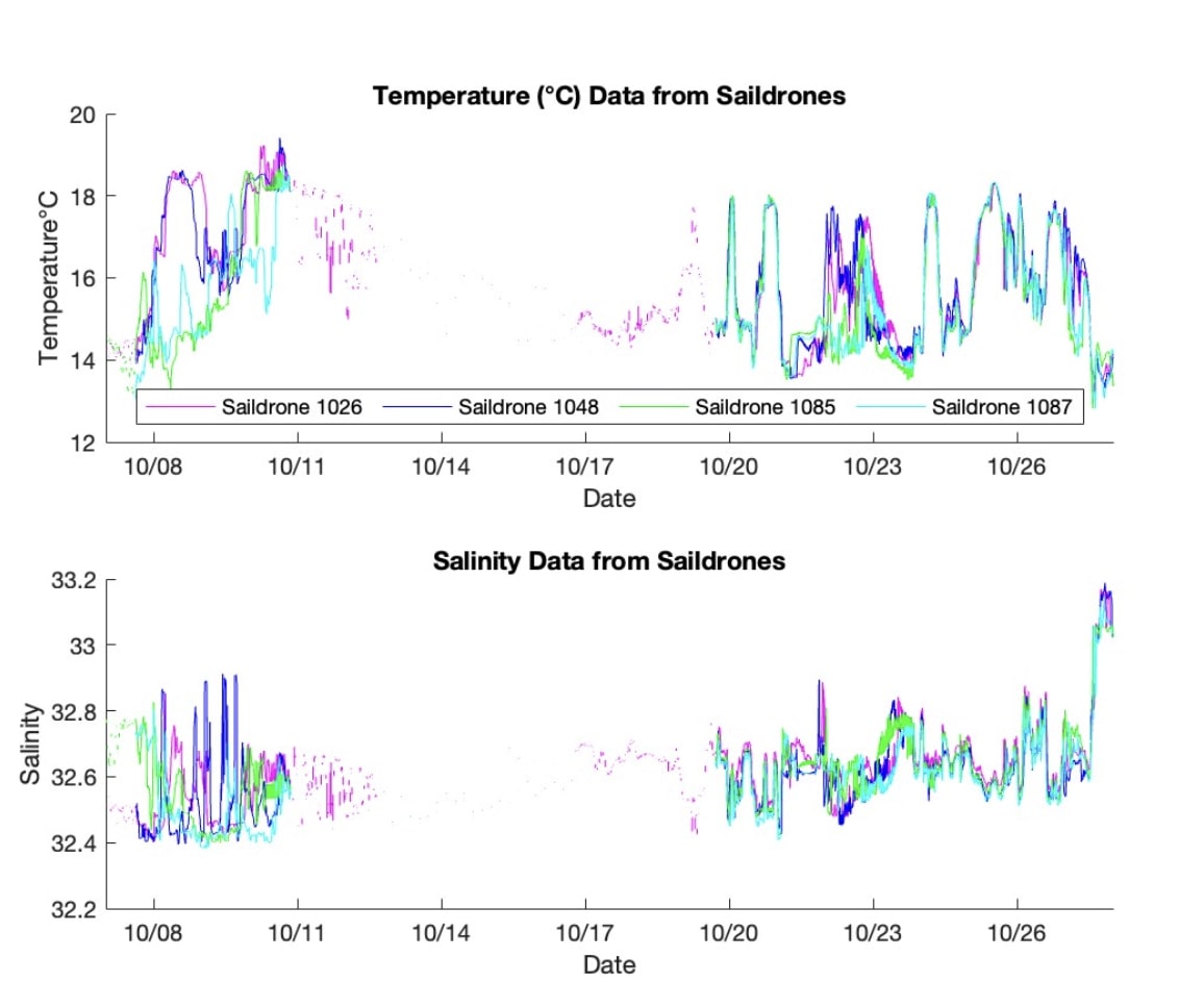
S-MODE L2 Temperature and Salinity from Saildrones Version 1
National Aeronautics and Space Administration —
This dataset contains Saildrone in-situ measurements taken during the Sub-Mesoscale Ocean Dynamics Experiment (S-MODE) conducted approximately 300 km offshore of San... -
Federal
GEOS-Carb CASA-GFED 3-hourly Ecosystem Exchange Fluxes 0.5 degree x 0.625 degree V3 (GEOS_CASAGFED_3H_NEE) at GES DISC
National Aeronautics and Space Administration —
This product provides 3 hourly average net ecosystem exchange (NEE) and gross ecosystem exchange (GEE) of Carbon derived from the Carnegie-Ames-Stanford-Approach –... -
Federal
GEOS-Carb CASA-GFED Monthly Fire Fuel NPP Rh NEE Fluxes 0.5 degree x 0.5 degree V3 (GEOS_CASAGFED_M_FLUX) at GES DISC
National Aeronautics and Space Administration —
This product provides Monthly average Net Primary Production (NPP), heterotrophic respiration (Rh), wildfire emissions (FIRE), and fuel wood burning emissions (FUEL)... -
Federal
Carbon Monitoring System Flux for Prior Total Carbon L4 V1 (CMSFluxTotalprior) at GES DISC
National Aeronautics and Space Administration —
This dataset provides the Carbon Flux for Prior Total Carbon. The NASA Carbon Monitoring System (CMS) is designed to make significant contributions in characterizing,... -
Federal
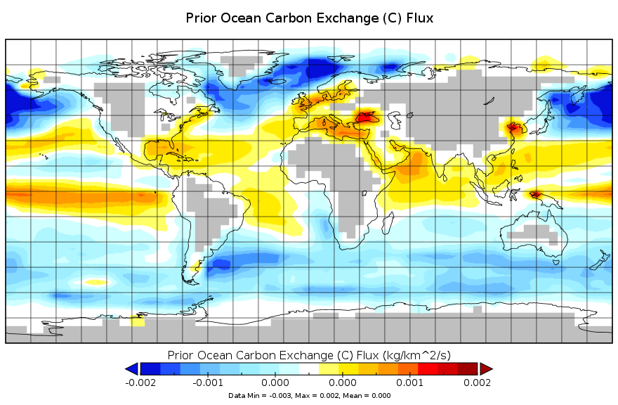
Carbon Monitoring System Carbon Flux for Ocean Prior L4 V2 (CMSFluxOceanPrior) at GES DISC
National Aeronautics and Space Administration —
This dataset provides the Carbon Flux for Ocean Carbon Prior. The NASA Carbon Monitoring System (CMS) is designed to make significant contributions in characterizing,... -
Federal
Saildrone field campaign surface and ADCP measurements for the Atlantic Tradewind Ocean-Atmosphere Mesoscale Interaction Campaign (ATOMIC) project
National Aeronautics and Space Administration —
Saildrone is a wind and solar powered unmanned surface vehicle (USV) capable of long distance deployments lasting up to 12 months and providing high quality, near... -
Federal
NOAA-21 VIIRS Regional Ocean Color (OC) Data, version R2022.0
National Aeronautics and Space Administration —
The Visible and Infrared Imager/Radiometer Suite (VIIRS) is a multi-disciplinary instrument that is being flown on the Joint Polar Satellite System (JPSS) series of... -
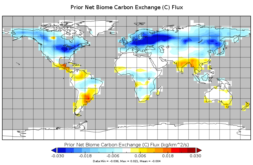
Federal
Carbon Monitoring System Carbon Flux from the Net Biome Exchange Prior L4 V2 (CMSFluxNBEPrior) at GES DISC
National Aeronautics and Space Administration —
This dataset provides the Carbon Flux from the Net Biome Exchange Prior. The NASA Carbon Monitoring System (CMS) is designed to make significant contributions in... -
Federal
Coordinated Eastern Arctic Experiment (CEAREX) Data, Version 1
National Aeronautics and Space Administration —
CEAREX was a multi-platform field program conducted in the Norwegian Seas and Greenland north to Svalbard from September 1988 through May 1989. Canada, Denmark,... -
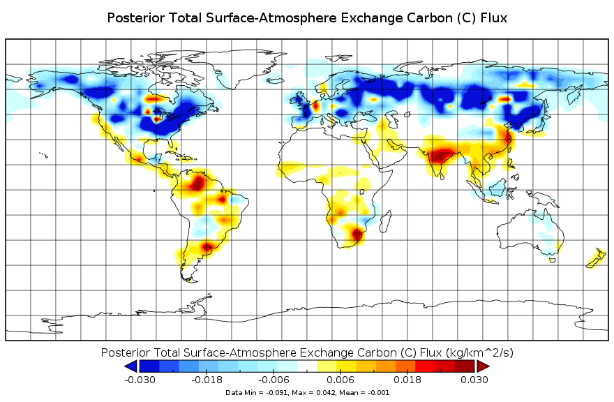
Federal
Carbon Monitoring System Carbon Flux Total L4 V2 (CMSFluxTotal) at GES DISC
National Aeronautics and Space Administration —
This dataset provides the Carbon Flux for Posterior Total Carbon. The NASA Carbon Monitoring System (CMS) is designed to make significant contributions in... -
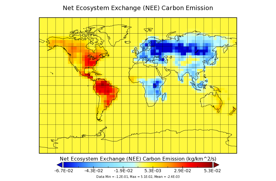
Federal
Carbon Monitoring System Flux from the Net Ecosystem Exchange L4 V1 (CMSFluxNEE) at GES DISC
National Aeronautics and Space Administration —
This dataset provides the Carbon Flux from the Net Ecosystem Exchange. The NASA Carbon Monitoring System (CMS) is designed to make significant contributions in... -
Federal
MACPEX WB-57 Aircraft In-situ Aerosol Data
National Aeronautics and Space Administration —
MACPEX_Aerosol_AircraftInSitu_WB57_Data is the in-situ aerosol data collected during the Mid-latitude Airborne Cirrus Properties Experiment (MACPEX). Data was... -
Federal
ISLSCP II Air-Sea Carbon Dioxide Gas Exchange
National Aeronautics and Space Administration —
This data set contains the calculated net ocean-air carbon dioxide (CO2) flux and sea-air CO2 partial pressure (pCO2) difference. The estimates are based on...

Official websites use .gov
A
.gov website belongs to an official government
organization in the United States.
Secure .gov websites use HTTPS
A
lock (
) or https:// means you’ve safely connected to
the .gov website. Share sensitive information only on official,
secure websites.