
-
Federal
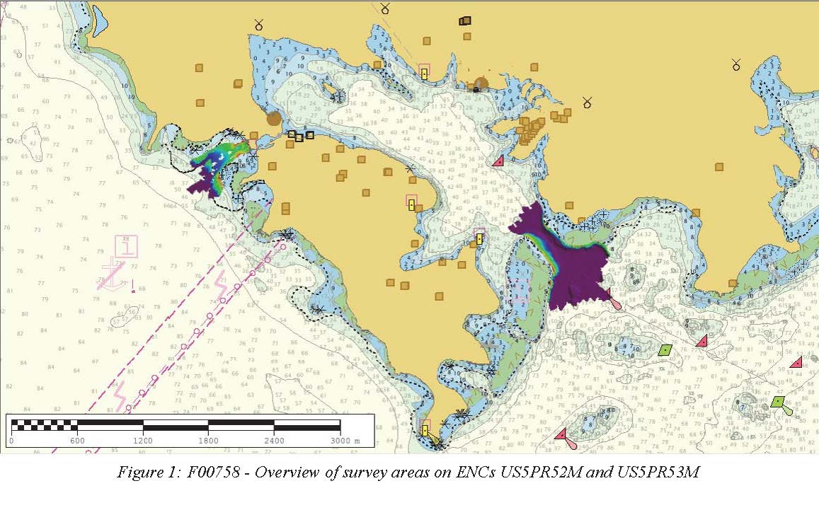
F00758: NOS Hydrographic Survey , 2018-10-30
National Oceanic and Atmospheric Administration, Department of Commerce —
The National Oceanic and Atmospheric Administration (NOAA) has the statutory mandate to collect hydrographic data in support of nautical chart compilation for safe... -
Federal
Shoreline change rates for the islands of Vieques and Culebra, Puerto Rico, calculated using the Digital Shoreline Analysis System version 5.1
Department of the Interior —
The U.S. Geological Survey (USGS) maintains shoreline positions for the United States coasts from both older sources, such as aerial photographs or topographic... -
Federal
Projected flood extent polygons and flood depth points based on 10-, 50-, 100-, and 500-year wave-energy return periods, with and without coral reefs, for the Territory of Puerto Rico (the islands of Culebra, Puerto Rico, and Vieques)
Department of the Interior —
This part of the data release presents projected flooding extent polygon (flood masks) and flooding depth points (flood points) shapefiles based on wave-driven total... -
Federal
2018 Mean High Water Shorelines of the Puerto Rico coast used in Shoreline Change Analysis
Department of the Interior —
The U.S. Geological Survey (USGS) maintains shoreline positions for the United States coasts from both older sources, such as aerial photos or topographic surveys, as... -
Federal
TIGER/Line Shapefile, 2022, County, Culebra Municipio, PR, Feature Names Relationship File
U.S. Census Bureau, Department of Commerce —
The TIGER/Line shapefiles and related database files (.dbf) are an extract of selected geographic and cartographic information from the U.S. Census Bureau's Master... -
Federal
24-bit True Color SW Quadrant of RINCON NE, Orthophoto Production for Puerto Rico and US Virgin Island (rincon4_2004.tif)
Department of the Interior —
This dataset is a single orthoimage from a collection of GeoTIFF format natural color orthoimages covering the islands of Puerto Rico, Mona, Desecheo, Culebra,... -
Federal
TIGER/Line Shapefile, 2023, County, Culebra Municipio, PR, All Roads
U.S. Census Bureau, Department of Commerce —
The TIGER/Line shapefiles and related database files (.dbf) are an extract of selected geographic and cartographic information from the U.S. Census Bureau's Master... -
Federal
TIGER/Line Shapefile, 2022, County, Culebra Municipio, PR, Address Ranges Relationship File
U.S. Census Bureau, Department of Commerce —
The TIGER/Line shapefiles and related database files (.dbf) are an extract of selected geographic and cartographic information from the U.S. Census Bureau's Master... -
Federal
Shoreline intersects for the islands of Vieques and Culebra, Puerto Rico, calculated using the Digital Shoreline Analysis System version 5.1
Department of the Interior —
The U.S. Geological Survey (USGS) maintains shoreline positions for the United States coasts from both older sources, such as aerial photographs or topographic... -
Federal
TIGER/Line Shapefile, 2022, County, Culebra Municipio, PR, Address Range-Feature
U.S. Census Bureau, Department of Commerce —
The TIGER/Line shapefiles and related database files (.dbf) are an extract of selected geographic and cartographic information from the U.S. Census Bureau's Master... -
Federal
TIGER/Line Shapefile, 2023, County, Culebra Municipio, PR, Topological Faces-Area Hydrography Relationship File
U.S. Census Bureau, Department of Commerce —
The TIGER/Line shapefiles and related database files (.dbf) are an extract of selected geographic and cartographic information from the U.S. Census Bureau's Master... -
Federal
TIGER/Line Shapefile, 2021, County, Culebra Municipio, PR, All Roads
U.S. Census Bureau, Department of Commerce —
The TIGER/Line shapefiles and related database files (.dbf) are an extract of selected geographic and cartographic information from the U.S. Census Bureau's Master... -
Federal
TIGER/Line Shapefile, 2023, County, Culebra Municipio, PR, Area Hydrography
U.S. Census Bureau, Department of Commerce —
The TIGER/Line shapefiles and related database files (.dbf) are an extract of selected geographic and cartographic information from the U.S. Census Bureau's Master... -
Federal
TIGER/Line Shapefile, 2022, County, Culebra Municipio, PR, Topological Faces-Area Hydrography Relationship File
U.S. Census Bureau, Department of Commerce —
The TIGER/Line shapefiles and related database files (.dbf) are an extract of selected geographic and cartographic information from the U.S. Census Bureau's Master... -
Federal
TIGER/Line Shapefile, 2023, County, Culebra Municipio, PR, Topological Faces (Polygons With All Geocodes)
U.S. Census Bureau, Department of Commerce —
The TIGER/Line shapefiles and related database files (.dbf) are an extract of selected geographic and cartographic information from the U.S. Census Bureau's Master... -
Federal
TIGER/Line Shapefile, 2020, County, Culebra Municipio, PR, Topological Faces (Polygons With All Geocodes)
U.S. Census Bureau, Department of Commerce —
The TIGER/Line shapefiles and related database files (.dbf) are an extract of selected geographic and cartographic information from the U.S. Census Bureau's Master... -
Federal
TIGER/Line Shapefile, 2022, County, Culebra Municipio, PR, Topological Faces (Polygons With All Geocodes)
U.S. Census Bureau, Department of Commerce —
The TIGER/Line shapefiles and related database files (.dbf) are an extract of selected geographic and cartographic information from the U.S. Census Bureau's Master... -
Federal
TIGER/Line Shapefile, 2022, County, Culebra Municipio, PR, Address Range-Feature Name Relationship File
U.S. Census Bureau, Department of Commerce —
The TIGER/Line shapefiles and related database files (.dbf) are an extract of selected geographic and cartographic information from the U.S. Census Bureau's Master... -
Federal
TIGER/Line Shapefile, 2023, County, Culebra Municipio, PR, Linear Hydrography
U.S. Census Bureau, Department of Commerce —
The TIGER/Line shapefiles and related database files (.dbf) are an extract of selected geographic and cartographic information from the U.S. Census Bureau's Master... -
Federal
Delineated Coastal Cliff Tops Derived from Post-Hurricane Maria Lidar Elevation Data Collected from Puerto Rico: 2018
Department of the Interior —
The National Assessment of Coastal Change Hazards project aims to understand and forecast coastal landscape change. This dataset consists of delineated coastal cliff...

Official websites use .gov
A
.gov website belongs to an official government
organization in the United States.
Secure .gov websites use HTTPS
A
lock (
) or https:// means you’ve safely connected to
the .gov website. Share sensitive information only on official,
secure websites.