
-
Federal
Meteorological Data (including visibility)
National Oceanic and Atmospheric Administration, Department of Commerce —
The National Ocean Service (NOS) maintains a long-term database containing data from active and historic stations installed all over the United States and U.S.... -
Federal
NOAA NEXt-Generation RADar (NEXRAD) Products NGDA
National Oceanic and Atmospheric Administration, Department of Commerce —
This dataset consists of Level III weather radar products collected from Next-Generation Radar (NEXRAD) stations located in the contiguous United States, Alaska,... -
Federal
GPM Ground Validation Doppler on Wheels (DOW) OLYMPEX V2
National Aeronautics and Space Administration —
The GPM Ground Validation Doppler on Wheels (DOW) OLYMPEX V2 dataset was obtained by a dual-polarization and dual-frequency X-band mobile radar operated by the Center... -
Federal
SWOT Level 1B Low-Rate Interferogram Data Product, Version 2.0
National Aeronautics and Space Administration —
Interferograms for each of the 9 Doppler beams formed and spatially averaged (low rate) by the On Board Processor, corrected on the ground for phase biases (inherent... -
Federal
GPM Ground Validation CXSI Radar Imagery OLYMPEX V1
National Aeronautics and Space Administration —
The GPM Ground Validation CXSI Radar Imagery OLYMPEX dataset contains radar reflectivity and precipitation rate images obtained from Environment and Climate Change... -
Federal
GPM Ground Validation Dual-frequency Dual-polarized Doppler Radar (D3R) ICE POP V1
National Aeronautics and Space Administration —
The GPM Ground Validation Dual-frequency Dual-polarized Doppler Radar (D3R) ICE POP dataset includes reflectivity, differential reflectivity, copolar correlation... -
Federal
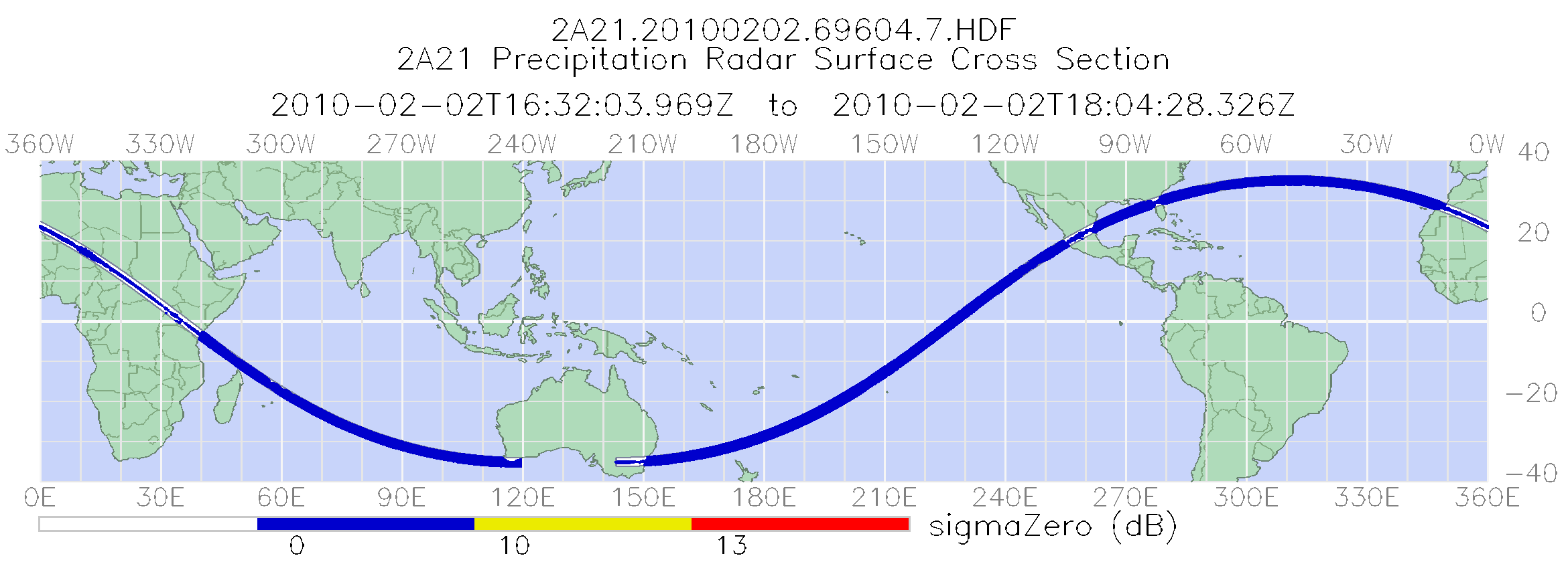
TRMM Precipitation Radar Surface Cross-Section L2 1.5 hours V7 (TRMM_2A21) at GES DISC
National Aeronautics and Space Administration —
The new version of these data is in GPM-like format (consistent with the GPM Dual-frequency Radar data format), and can be found under the name GPM_2APR. This is the... -
Federal
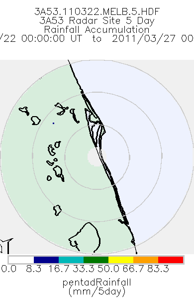
TRMM Ground Validation Radar Site Rain Totals Map L3 5 days 2 km V7 (TRMM_3A53) at GES DISC
National Aeronautics and Space Administration —
This is the 5-day accumulation of the 2A53 product, 'Radar Site Rain Map', which originally is an instantaneous surface rain rate map in Cartesian coordinates with a... -
Federal
TRMM Ground Validation Radar Site Rain Rate Map L2 1 hour 2 km V7 (TRMM_2A53) at GES DISC
National Aeronautics and Space Administration —
'Radar Site Rain Map', is an instantaneous surface rain rate map in Cartesian coordinates with a 2 km horizontal resolution. At single radar sites, the map covers an... -
Federal
2002/2003 IfSAR data for Southern California: Radar Reflectance Image
National Oceanic and Atmospheric Administration, Department of Commerce —
This metadata document describes the collection and processing of topographic elevation point data derived from Interferometric Synthetic Aperture Radar (IfSAR)... -
Federal
2002/2003 IfSAR data for Southern California: Digital Elevation Model (NAVD88)
National Oceanic and Atmospheric Administration, Department of Commerce —
This metadata document describes the collection and processing of topographic elevation point data derived from Interferometric Synthetic Aperture Radar (IfSAR)... -
Federal
GPM GROUND VALIDATION NASA S-BAND DUAL POLARIMETRIC (NPOL) DOPPLER RADAR MC3E V1
National Aeronautics and Space Administration —
The GPM Ground Validation NASA S-band Dual Polarimetric (NPOL) Doppler Radar MC3E dataset was collected by the NASA NPOL radar, which was developed by a research team... -
Federal
Next Generation Weather Radar (NEXRAD) Setback (4-km)
Department of Energy —
The Next Generation Weather Radar (NEXRAD) system is a network of doppler radar operated jointly by the National Weather Service (NWS), the Federal Aviation... -
Federal
TRMM Ground Validation Calibrated QC Radar Reflectivity Full Volume Scan L1C 1 hour V7 (TRMM_1C51UW) at GES DISC
National Aeronautics and Space Administration —
This dataset is part of the University of Washington TRMM Ground Validation products. Files are in "Universal Format", described in BAMS, Vol 61, No 11, November... -
Federal
Gazetteer of Planetary Nomenclature: Venus: 1:10 million-scale Altimetry Quadrangles: Aphrodite
National Aeronautics and Space Administration —
This set of maps diplays altimetric radar images of Venus approved by the International Astronomical Union (IAU). -
Federal
SWOT Level 2 Radiometer Brightness Temperatures and Troposphere Operational Data Product Version 1.0
National Aeronautics and Space Administration —
The SWOT Level 2 Radiometer Brightness Temperatures and Troposphere Operational Geophysical Data Record (OGDR) Version 1.0 dataset produced by the Surface Water and... -
Federal
TRMM Ground Validation Radar Reflectivity Single Level Cartesian Grid 1 hour V7 (TRMM_baseUW) at GES DISC
National Aeronautics and Space Administration —
This dataset is part of the University of Washington TRMM Ground Validation products. Data contains single level, cartesian grids containing output of NCAR SPRINT... -
Federal
GPM Ground Validation National Mosaic and Multi-Sensor QPE (NMQ) System IFloodS V1
National Aeronautics and Space Administration —
The GPM Ground Validation National Mosaic and Multi-Sensor QPE (NMQ) System IFloodS dataset contains quality control products, real time rain rate estimates, hourly... -
Federal
Graph Theory for Analyzing Pair-wise Data: Application to Interferometric Synthetic Aperture Radar Data
Department of Energy —
Graph theory is useful for estimating time-dependent model parameters via weighted least-squares using interferometric synthetic aperture radar (InSAR) data. Plotting... -
Federal
Cloud Radar System (CRS) IMPACTS V1
National Aeronautics and Space Administration —
The Cloud Radar System (CRS) IMPACTS dataset consists of calibrated radar reflectivity, Doppler velocity, linear depolarization ratio, and normalized radar cross-...

Official websites use .gov
A
.gov website belongs to an official government
organization in the United States.
Secure .gov websites use HTTPS
A
lock (
) or https:// means you’ve safely connected to
the .gov website. Share sensitive information only on official,
secure websites.