
-
Federal
Sea Level Trends: Sea Level Variations of the United States Derived from National Water Level Observation Network Stations NGDA
National Oceanic and Atmospheric Administration, Department of Commerce —
Water level records are a combination of the fluctuations of the ocean and the vertical land motion at the location of the station. Monthly mean sea level (MSL)... -
Federal
Meteorological Data (including visibility)
National Oceanic and Atmospheric Administration, Department of Commerce —
The National Ocean Service (NOS) maintains a long-term database containing data from active and historic stations installed all over the United States and U.S.... -
Federal
NOAA NEXt-Generation RADar (NEXRAD) Products NGDA
National Oceanic and Atmospheric Administration, Department of Commerce —
This dataset consists of Level III weather radar products collected from Next-Generation Radar (NEXRAD) stations located in the contiguous United States, Alaska,... -
Federal
Tides and Currents Map: an interactive map of all CO-OPS stations NGDA
National Oceanic and Atmospheric Administration, Department of Commerce —
This interactive map has many features designed to provide a quick and easy way to find a Center for Operational Oceanographic Products and Services (CO-OPS) station.... -
Federal
U.S. Local Climatological Data (LCD)
National Oceanic and Atmospheric Administration, Department of Commerce —
Local Climatological Data (LCD) are summaries of climatological conditions from airport and other prominent weather stations managed by NWS, FAA, and DOD. The product... -
Federal
High Resolution Aerial Photography of Puerto Rico and the U.S. Virgin Islands, 1965-1999
National Oceanic and Atmospheric Administration, Department of Commerce —
Aerial photographs were acquired for the Puerto Rico and U.S. Virgin Islands Benthic Mapping Project in 1999 by NOAA Aircraft Operation Centers aircraft and National... -
Federal
National Estuarine Research Reserve System - NERRS - Water Quality Data
National Oceanic and Atmospheric Administration, Department of Commerce —
Water quality observations made over long time periods can provide important feedback to scientists and to local, state, and national resource managers about actions... -
Federal
Bluefin Tuna Commercial Domestic Landings
National Oceanic and Atmospheric Administration, Department of Commerce —
All commercially landed bluefin tuna must be reported to the National Marine Fisheries Service (NMFS) so that NMFS can ensure the fishery stays within the U.S. quota.... -
Federal
Physical Oceanographic (Water Temperature and Conductivity) Data
National Oceanic and Atmospheric Administration, Department of Commerce —
NOAA's Center for Operational Oceanographic Products and Services (CO-OPS) is the authoritative source for accurate, reliable, and timely data on tides, water levels,... -
Federal
Automated Landing Reporting System (ALRS)
National Oceanic and Atmospheric Administration, Department of Commerce —
Anglers are required to report all recreationally caught Atlantic bluefin tuna, billfish, and swordfish to NMFS, provided the landings are not affiliated with a... -
Federal
U.S. Interagency Elevation Inventory (USIEI) - Data Download
National Oceanic and Atmospheric Administration, Department of Commerce —
The U.S. Interagency Elevation Inventory (USIEI) displays high-accuracy topographic and bathymetric data for the United States and its territories. The project is a... -
Federal
NOAA Tidal Currents for Coastal, Estuaries and Great Lakes (non-tidal) regions
National Oceanic and Atmospheric Administration, Department of Commerce —
Since the late-1800s, NOAAâs Center for Operational Oceanographic Products and Services (CO-OPS) and its predecessors have been collecting, analyzing and... -
Federal
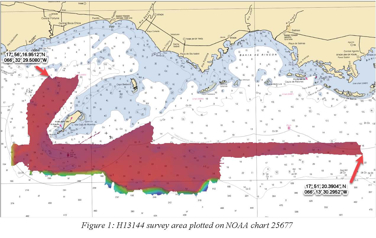
H13144: NOS Hydrographic Survey , 2018-11-02
National Oceanic and Atmospheric Administration, Department of Commerce —
The National Oceanic and Atmospheric Administration (NOAA) has the statutory mandate to collect hydrographic data in support of nautical chart compilation for safe... -
Federal
2013 NOAA Topographic Lidar DEM: U.S. Virgin Islands (St. Croix, St. John, St. Thomas)
National Oceanic and Atmospheric Administration, Department of Commerce —
The United States Virgin Islands Topographic LiDAR Task Order involved collecting and delivering topographic elevation point data derived from multiple return light... -
Federal
Geodetic Control Information on Passive Marks NGDA
National Oceanic and Atmospheric Administration, Department of Commerce —
This data contains a set of geodetic control stations maintained by the National Geodetic Survey. Each geodetic control station in this dataset has either a precise... -
Federal
Recovery of Queen Conch in the U. S. Virgin Islands
National Oceanic and Atmospheric Administration, Department of Commerce —
The queen conch is an important cultural component and an extremely valuable coral reef fishery resource throughout the Caribbean, historically second only to the... -
Federal
Elkhorn coral demographic monitoring from 2004-03-30 to 2024-08-15 (NCEI Accession 0142175)
National Oceanic and Atmospheric Administration, Department of Commerce —
The overall objectives of this project are to document the dynamics of the remaining Elkhorn populations in the upper Florida Keys and to compare its performance to... -
Federal
2025 NOAA NGS Emergency Response Imagery: Hurricane Melissa
National Oceanic and Atmospheric Administration, Department of Commerce —
Aerial imagery was acquired following Hurricane Melissa in targeted areas in Jamaica. The aerial photography missions were conducted by the NOAA Remote Sensing... -
Federal
H12640: NOS Hydrographic Survey , 2014-04-02
National Oceanic and Atmospheric Administration, Department of Commerce —
The National Oceanic and Atmospheric Administration (NOAA) has the statutory mandate to collect hydrographic data in support of nautical chart compilation for safe...

Official websites use .gov
A
.gov website belongs to an official government
organization in the United States.
Secure .gov websites use HTTPS
A
lock (
) or https:// means you’ve safely connected to
the .gov website. Share sensitive information only on official,
secure websites.