Recovery of Queen Conch in the U. S. Virgin Islands
Access & Use Information
Downloads & Resources
-
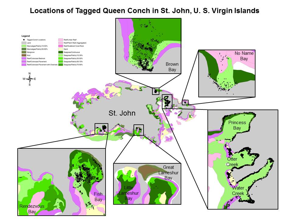
locations_of_tagged_queen_conch.jpgJPEG
locations_of_tagged_queen_conch.jpg
-
24265.zipZIP
Contains all child items of the dataset zipped into one file.
-
Full Metadata Record
View the complete metadata record on InPort for more information about this...
-
Southeast Fisheries Science Center Website
About SEFSC
-
Sedar 14 Report on Caribbean Queen ConchPDF
2007 Stock Assessment Report on Caribbean Queen Conch
-
GCMD Keyword Forum Page
Global Change Master Directory (GCMD). 2024. GCMD Keywords, Version 19....
-
NOAA Data Management Plan (DMP)PDF
NOAA Data Management Plan for this record on InPort.
Dates
| Metadata Date | May 15, 2025 |
|---|---|
| Metadata Created Date | November 12, 2020 |
| Metadata Updated Date | June 1, 2025 |
| Reference Date(s) | 2012 (publication) |
| Frequency Of Update | notPlanned |
Metadata Source
- ISO-19139 ISO-19139 Metadata
Harvested from NMFS SEFSC
Graphic Preview

Additional Metadata
| Resource Type | Dataset |
|---|---|
| Metadata Date | May 15, 2025 |
| Metadata Created Date | November 12, 2020 |
| Metadata Updated Date | June 1, 2025 |
| Reference Date(s) | 2012 (publication) |
| Responsible Party | (Point of Contact, Custodian) |
| Contact Email | |
| Guid | gov.noaa.nmfs.inport:24265 |
| Access Constraints | Cite As: Southeast Fisheries Science Center, [Date of Access]: Recovery of Queen Conch in the U. S. Virgin Islands [Data Date Range], https://www.fisheries.noaa.gov/inport/item/24265., Access Constraints: The National Marine Fisheries Service (NMFS) does not approve, recommend, or endorse any proprietary product or proprietary material contained in this data set. The NMFS Galveston Laboratory Fishery Ecology Branch compiled these data sets in order to develop a scientific basis for refining essential fish habitat designations for future amendments to fishery management plans. NMFS is not responsible for any uses of these data sets beyond those for which they were intended, and NMFS makes no claims regarding the accuracy of any data provided by agencies or individuals outside NMFS., Use Constraints: The National Marine Fisheries Service (NMFS) does not approve, recommend, or endorse any proprietary product or proprietary material contained in this data set. The NMFS Galveston Laboratory Fishery Ecology Branch compiled these data sets in order to develop a scientific basis for refining essential fish habitat designations for future amendments to fishery management plans. NMFS is not responsible for any uses of these data sets beyond those for which they were intended, and NMFS makes no claims regarding the accuracy of any data provided by agencies or individuals outside NMFS., Distribution Liability: While every effort has been made to ensure that these data are accurate and reliable within the limits of the current state of the art, NOAA cannot assume liability for any damages caused by errors or omissions in the data, nor as a result of the failure of the data to function on a particular system. NOAA makes no warranty, expressed or implied, nor does the fact of distribution constitute such a warranty. |
| Bbox East Long | -64.661 |
| Bbox North Lat | 18.388 |
| Bbox South Lat | 18.286 |
| Bbox West Long | -64.794 |
| Coupled Resource | |
| Frequency Of Update | notPlanned |
| Graphic Preview Description | All Tag Locations All Bays - Information from mark and recapture and habitat studies. |
| Graphic Preview File | https://data.nodc.noaa.gov/coris/data/NOAA/nmfs/1873/locations_of_tagged_queen_conch.jpg |
| Graphic Preview Type | jpeg |
| Harvest Object Id | f87b73fb-9da5-4fe9-92d7-98cf3059de33 |
| Harvest Source Id | ca759a40-507d-4d0c-8f8c-64b3c5e05066 |
| Harvest Source Title | NMFS SEFSC |
| Licence | NOAA provides no warranty, nor accepts any liability occurring from any incomplete, incorrect, or misleading data, or from any incorrect, incomplete, or misleading use of the data. It is the responsibility of the user to determine whether or not the data is suitable for the intended purpose. |
| Lineage | |
| Metadata Language | eng |
| Metadata Type | geospatial |
| Old Spatial | {"type": "Polygon", "coordinates": [[[-64.794, 18.286], [-64.661, 18.286], [-64.661, 18.388], [-64.794, 18.388], [-64.794, 18.286]]]} |
| Progress | completed |
| Spatial Data Service Type | |
| Spatial Reference System | |
| Spatial Harvester | True |
| Temporal Extent Begin | 2005-05-01 |
| Temporal Extent End | 2010-09-01 |
Didn't find what you're looking for? Suggest a dataset here.

