
-
Federal
CERES and GEO-Enhanced TOA, Within-Atmosphere and Surface Fluxes, Clouds and Aerosols 3-Hourly Terra-Aqua Edition4A NGDA
National Aeronautics and Space Administration —
CER_SYN1deg-3Hour_Terra-Aqua-MODIS_Edition4A is the Clouds and the Earth's Radiant Energy System (CERES) and geostationary (GEO)-Enhanced Top of Atmosphere (TOA),... -
Federal
OMI/Aura Multi-wavelength Aerosol Optical Depth and Single Scattering Albedo Daily L2 Global Gridded 0.25 degree x 0.25 degree V3 (OMAEROG) at GES DISC
National Aeronautics and Space Administration —
This Level-2G daily global gridded product OMAEROG is based on the pixel level OMI Level-2 Aerosol product OMAERO, based on the multi-wavelength algorithm that uses... -
Federal
National Solar Radiation Database (NSRDB) Station Data Output for 1991 to 2010
National Oceanic and Atmospheric Administration, Department of Commerce —
The National Solar Radiation Database (NSRDB) was produced by the National Renewable Energy Laboratory under the U.S. Department of Energy's Office of Energy... -
Federal
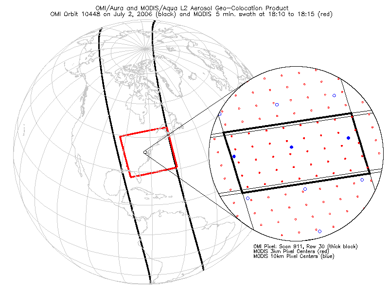
OMI/Aura and MODIS/Aqua Aerosol Geo-colocation Product 1-Orbit L2 Swath 13x24 km V003 (OMMYDAGEO) at GES DISC NGDA
National Aeronautics and Space Administration —
The OMI/Aura and MODIS/Aqua Aerosol Geo-colocation Product 1-Orbit L2 Swath 13x24 km (OMMYDAGEO) is a Level-2 orbital data product that links the MODIS/Aqua aerosol... -
Federal
Polar Ozone and Aerosol Measurement III
National Aeronautics and Space Administration —
POAM3 data are Polar Ozone and Aerosol Measurement III Version 3.0. The Polar Ozone and Aerosol Measurement (POAM) III instrument measures the vertical distribution... -
Federal
CERES Clouds and Radiative Swath Aqua FM3 MODIS Edition2C
National Aeronautics and Space Administration —
CER_CRS_Aqua-FM3-MODIS_Edition2c is the Clouds and the Earth's Radiant Energy System (CERES) Clouds and Radiative Swath (CRS) Aqua-Flight Model 3 (FM3) Moderate-... -
Federal
GOES-R PLT Cloud Physics LiDAR (CPL) V1
National Aeronautics and Space Administration —
The GOES-R PLT Cloud Physics Lidar (CPL) dataset consists of backscatter coefficient, lidar depolarization ratio, layer top/base height, layer type, particulate... -
Federal
FLASHFlux Daily Gridded Single Satellite TOA and Surfaces/Clouds data Version 4B
National Aeronautics and Space Administration —
FLASH_TISA_Terra-NOAA20_Version4B is the Fast Longwave And SHortwave Fluxes (FLASHFlux) Daily Gridded Single Satellite Top-of-Atmosphere (TOA) and Surfaces/Clouds... -
Federal
CERES MODIS Cloud Retrievals in ISCCP-D2like Format Day Terra FM2 Edition3A NGDA
National Aeronautics and Space Administration —
CER_ISCCP-D2like-Day_Terra-FM2-MODIS_Edition3A is the Clouds and the Earth's Radiant Energy System (CERES) Moderate Resolution Imaging Spectroradiometer (MODIS) Cloud... -
Federal
CERES MODIS Cloud Retrievals in ISCCP-D2like Format Nighttime Aqua FM4 Edition3A NGDA
National Aeronautics and Space Administration —
CER_ISCCP-D2like-Nit_Aqua-FM4-MODIS_Edition3A is the Clouds and the Earth's Radiant Energy System (CERES) Moderate Resolution Imaging Spectroradiometer (MODIS) Cloud... -
Federal
NOAA GOES-R Series Advanced Baseline Imager (ABI) Level 2 Aerosol Optical Depth (AOD)
National Oceanic and Atmospheric Administration, Department of Commerce —
The GOES-R Advanced Baseline Imager (ABI) Aerosol Optical Depth product contains an image with pixel values identifying a measure of the extinction due to atmospheric... -
Federal
National Solar Radiation Database (NSRDB) SolarAnywhere 10 km Model Output for 1989 to 2009
National Oceanic and Atmospheric Administration, Department of Commerce —
The National Solar Radiation Database (NSRDB) was produced by the National Renewable Energy Laboratory under the U.S. Department of Energy's Office of Energy... -
Federal
TRACE-P P-3B In-Situ Aerosol Data
National Aeronautics and Space Administration —
TRACE-P_Aerosol_AircraftInSitu_P3B_Data is the in-situ aerosol data collected onboard the P-3B aircraft during the Transport and Chemical Evolution over the Pacific... -
Federal
AIRS/Aqua L2 Near Real Time (NRT) Support Retrieval (AIRS-only) V006 (AIRS2SUP_NRT) at GES DISC
National Aeronautics and Space Administration —
The Atmospheric Infrared Sounder (AIRS) Level 2 Near Real Time (NRT) Support Retrieval (AIRS-only) product (AIRS2SUP_NRT_006) differs from the routine product... -
Federal
NOAA GOES-R Series Advanced Baseline Imager (ABI) Level 2 Volcanic Ash: Detection and Height (VAA)
National Oceanic and Atmospheric Administration, Department of Commerce —
The Volcanic Ash: Detection and Height product contains two images with pixel values identifying volcanic ash cloud height and volcanic ash mass loading. The ash... -
Federal
NOAA GOES-R Series Advanced Baseline Imager (ABI) Level 2 Aerosol Detection (ADP)
National Oceanic and Atmospheric Administration, Department of Commerce —
The GOES-R Advanced Baseline Imager (ABI) Aerosol Detection product contains three images in the form of binary masks that identify the presence of aerosols, dust,... -
Federal
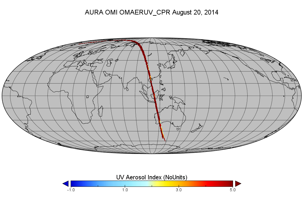
OMI/Aura Level 2 Near UV Aerosol Optical Depth and Single Scattering Albedo 200-m swath subset along CloudSat track V003 (OMAERUV_CPR) at GES DISC
National Aeronautics and Space Administration —
This is a CloudSat-collocated subset of the original OMI product OMAERUV, for the purposes of the A-Train mission. The goal of the subset is to select and return OMI... -
Federal
FLASHFlux Daily Gridded TOA and Surfaces/Clouds data Version 4C
National Aeronautics and Space Administration —
FLASH_TISA_Terra-NOAA20_Version4C is the Fast Longwave And SHortwave Fluxes (FLASHFlux) Daily Gridded Top-of-Atmosphere (TOA) and Surfaces/Clouds Version 4C data... -
Federal
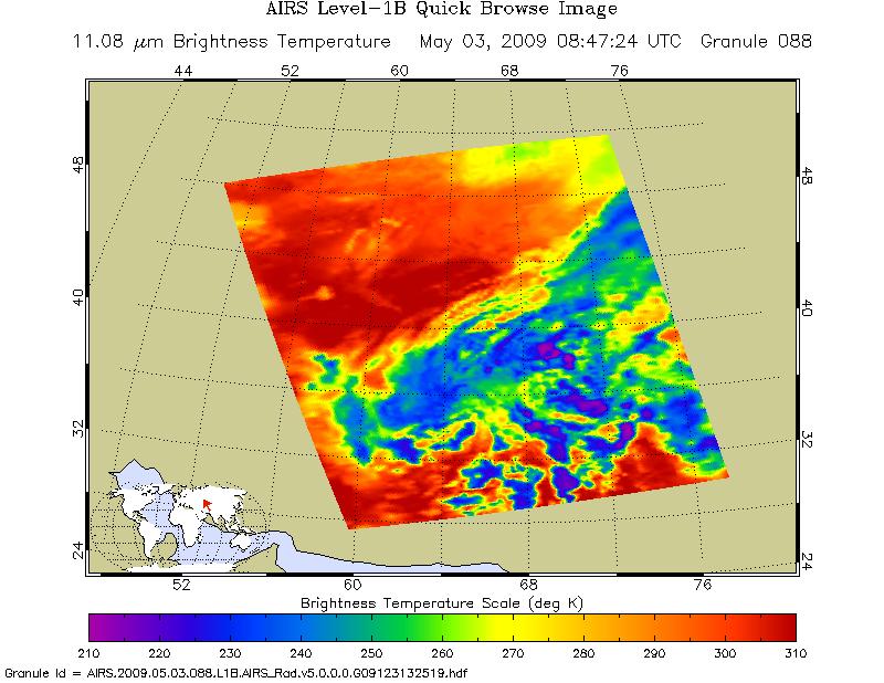
AIRS/Aqua L1B Near Real Time (NRT) Infrared (IR) geolocated and calibrated radiances V8.0 (AIRSAQIRL1B_NRT) at GES DISC
National Aeronautics and Space Administration —
The Atmospheric Infrared Sounder (AIRS) is a grating spectrometer (R = 1200) aboard the second Earth Observing System (EOS) polar-orbiting platform, EOS Aqua. In... -
Federal
Lidar Atmospheric Sensing Experiment (LASE) Validation
National Aeronautics and Space Administration —
An extensive validation experiment was conducted in September 1995 from Wallops Island, Virginia, to evaluate the performance of the LASE (Lidar Atmospheric Sensing...

Official websites use .gov
A
.gov website belongs to an official government
organization in the United States.
Secure .gov websites use HTTPS
A
lock (
) or https:// means you’ve safely connected to
the .gov website. Share sensitive information only on official,
secure websites.