
-
Federal
CMS: LiDAR Data for Forested Areas in Paragominas, Para, Brazil, 2012-2014
National Aeronautics and Space Administration —
This data set provides raw LiDAR point cloud data and derived Digital Terrain Models (DTMs) for five forested areas in the municipality of Paragominas, Para, Brazil,... -
Federal
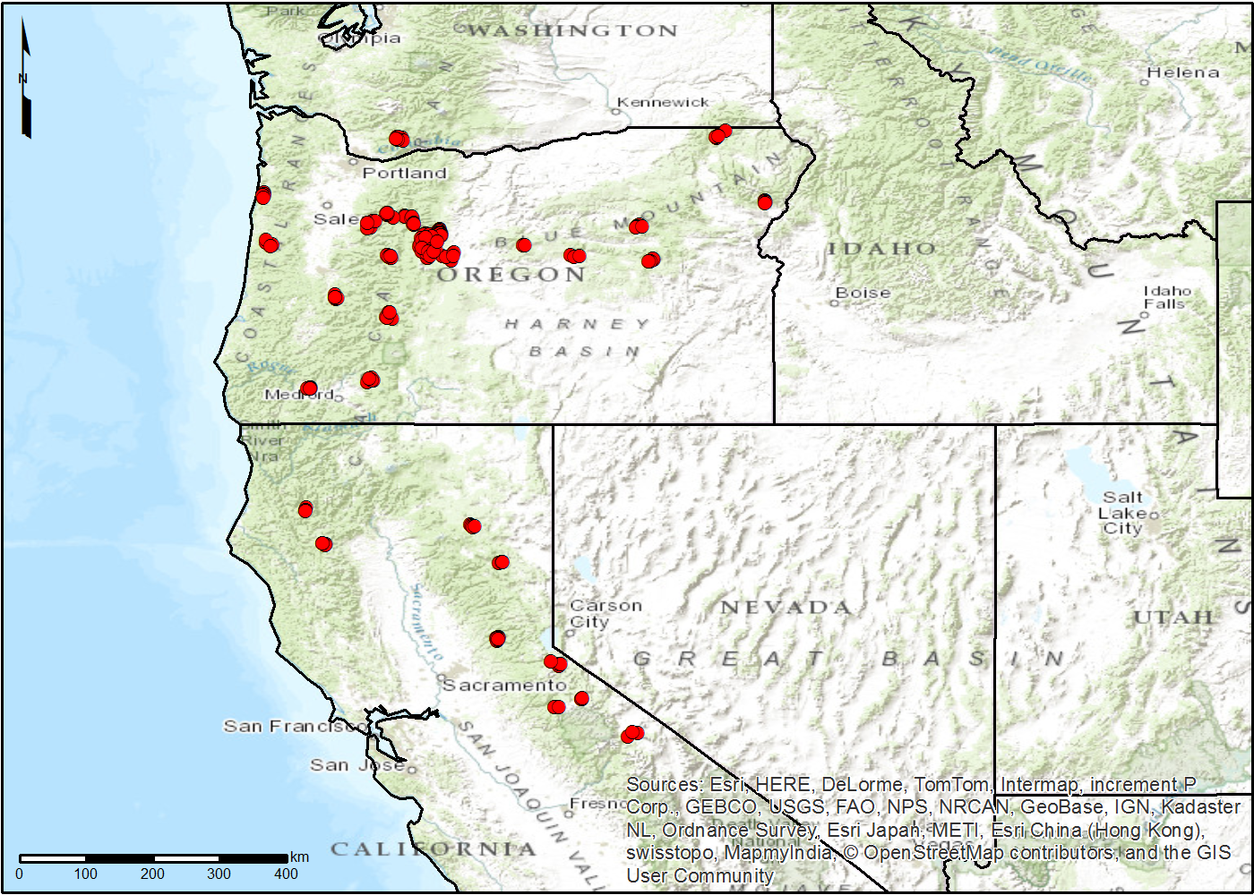
NACP TERRA-PNW: Forest Plant Traits, NPP, Biomass, and Soil Properties, 1999-2014
National Aeronautics and Space Administration —
This data set contains measurements and estimates of leaf, tree, and soil data from six projects conducted by the Terrestrial Ecosystem Research and Regional... -
Federal
AfriSAR: Polarimetric Height Profiles by TomoSAR, Lope and Rabi Forests, Gabon, 2016
National Aeronautics and Space Administration —
This dataset provides height profiles derived from UAVSAR (Uninhabited Aerial Vehicle Synthetic Aperture Radar; JPL) data acquired over Lope National Park and Rabi... -
Federal
ABoVE: Subsistence Resource Use Areas of Interior Alaskan Communities, 2011-2017
National Aeronautics and Space Administration —
This dataset provide maps to show the search and harvest areas used by community residents for all subsistence resources combined across Interior Alaska for the years... -
Federal
FLUXNET Research Network Site Characteristics, Investigators, and Bibliography, 2016
National Aeronautics and Space Administration —
FLUXNET is a global network of micrometeorological tower sites that use eddy covariance methods to measure the exchanges of carbon dioxide, water vapor, and energy... -
Federal
CMS: LiDAR Data for Mangrove Forests in the Zambezi River Delta, Mozambique, 2014
National Aeronautics and Space Administration —
This data set provides high-resolution LiDAR point cloud data collected during surveys over mangrove forests in the Zambezi River Delta in Mozambique in May 2014. The... -
Federal
Geobotanical and Impact Map Collection for Prudhoe Bay Oilfield, Alaska, 1972-2010
National Aeronautics and Space Administration —
This data set provides a collection of maps of geoecological characteristics of areas within the Beechey Point quadrangle near Prudhoe Bay on the North slope of... -
Federal
ABoVE: Permafrost Measurements and Distribution Across the Y-K Delta, Alaska, 2016
National Aeronautics and Space Administration —
This dataset provides field observations of thaw depth and dominant vegetation types, a LiDAR-derived elevation map, and permafrost distribution and probability maps... -
Federal
Land Cover and Ecosystem Map Collection for Northern Alaska
National Aeronautics and Space Administration —
This data set provides four land cover and ecosystem classification maps for northern Alaska. The maps were produced for several projects and from different data... -
Federal
CMS: LiDAR-derived Canopy Height, Elevation for Sites in Kalimantan, Indonesia, 2014
National Aeronautics and Space Administration —
This dataset provides canopy height and elevation data products derived from airborne LiDAR data collected over 90 sites on the island of Borneo in late 2014. The... -
Federal
NACP Peatland Land Cover Map of Upper Peninsula, Michigan, 2007-2011
National Aeronautics and Space Administration —
This dataset provides a land cover map focused on peatland ecosystems in the upper peninsula of Michigan. The map was produced at 12.5-m resolution using a multi-... -
Federal
NACP Soil Organic Matter of Burned Boreal Black Spruce Forests, Alaska, 2009-2011
National Aeronautics and Space Administration —
This data set provides organic soil layer characteristics, estimated carbon content, and soil depth measurements made at four black spruce stands in interior Alaska... -
Federal
Arctic Alaska Vegetation, Geobotanical, Physiographic Maps, 1993-2005
National Aeronautics and Space Administration —
This data set provides the spatial distributions of vegetation types, geobotanical characteristics, and physiographic features for the Arctic tundra region of Alaska... -
Federal
Maps of Vegetation Types and Physiographic Features, Toolik Lake Area, Alaska
National Aeronautics and Space Administration —
This data set provides the spatial distributions of vegetation types, soil carbon, and physiographic features in the Toolik Lake area, Alaska. Specific attributes... -
Federal
ABoVE: Burn Severity, Fire Progression, Landcover and Field Data, NWT, Canada, 2014 NGDA
National Aeronautics and Space Administration —
This data set provides peatland landcover classification maps, fire progression maps, and vegetation community biophysical data collected from areas that were burned... -
Federal
Land Cover and Vegetation Map Collection for Seward Peninsula, Alaska
National Aeronautics and Space Administration —
This data set provides two landcover and vegetation maps for the Seward Peninsula, Alaska. These maps were produced from existing maps, Landsat imagery, and color... -
Federal
ABoVE: Gridded 30-m Aboveground Biomass, Shrub Dominance, North Slope, AK, 2007-2016
National Aeronautics and Space Administration —
This dataset includes 30-m gridded estimates of total plant aboveground biomass (AGB), the shrub AGB, and the shrub dominance (shrub/plant AGB) for non-water portions... -
Federal
LiDAR Data, DEM, and Maximum Vegetation Height Product from Southern Idaho, 2014
National Aeronautics and Space Administration —
This dataset provides the point cloud data derived from small footprint waveform LiDAR data collected in August 2014 over Reynolds Creek Experimental Watershed and... -
Federal
Maps of Vegetation Types and Physiographic Features, Kuparuk River Basin, Alaska
National Aeronautics and Space Administration —
This data set provides a collection of vegetation, landscape, geobotanical, elevation, hydrology, and geologic maps for the Kuparuk River Basin, North Slope, Alaska.... -
Federal
ABoVE: Burn Severity, Fire Progression, and Field Data, NWT, Canada, 2015-2016 NGDA
National Aeronautics and Space Administration —
This data set provides a fire progression map for year 2015 and measures of burn severity and vegetation community biophysical data collected from areas that were...

Official websites use .gov
A
.gov website belongs to an official government
organization in the United States.
Secure .gov websites use HTTPS
A
lock (
) or https:// means you’ve safely connected to
the .gov website. Share sensitive information only on official,
secure websites.