

11 datasets found
-
Federal
SWOT Level 2 Radiometer Brightness Temperatures and Troposphere Operational Data Product Version 1.0
National Aeronautics and Space Administration —
The SWOT Level 2 Radiometer Brightness Temperatures and Troposphere Operational Geophysical Data Record (OGDR) Version 1.0 dataset produced by the Surface Water and... -
Federal
SWOT Level 1B High-Rate Single-look Complex Data Product, Version 2.0
National Aeronautics and Space Administration —
High rate data processed to single-look complex SAR images for each antenna. Gridded tile (approx 64x64 km2); half swath (left or right side of full swath). Available... -
Federal
SWOT Level 1B Low-Rate Interferogram Data Product, Version 2.0
National Aeronautics and Space Administration —
Interferograms for each of the 9 Doppler beams formed and spatially averaged (low rate) by the On Board Processor, corrected on the ground for phase biases (inherent... -
Federal
SWOT Level 2 Radiometer Brightness Temperatures and Troposphere Operational Data Product, Version 2.0
National Aeronautics and Space Administration —
The SWOT Level 2 Radiometer Brightness Temperatures and Troposphere Operational Geophysical Data Record (OGDR) Version 1.0 dataset produced by the Surface Water and... -
Federal
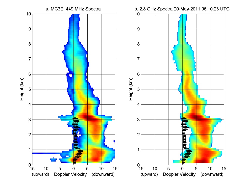
GPM GROUND VALIDATION NOAA UHF 449 PROFILER MC3E V1
National Aeronautics and Space Administration —
The GPM Ground Validation NOAA UHF 449 Profiler MC3E dataset was collected during the NASA supported Midlatitude Continental Convective Clouds Experiment (MC3E). The... -
Federal
SWOT Level 2 Radiometer Brightness Temperatures and Troposphere Interim Data Product, Version 2.0
National Aeronautics and Space Administration —
The SWOT Level 2 Radiometer Brightness Temperatures and Troposphere Interim Geophysical Data Record (IGDR) Version 1.0 dataset produced by the Surface Water and Ocean... -
Federal
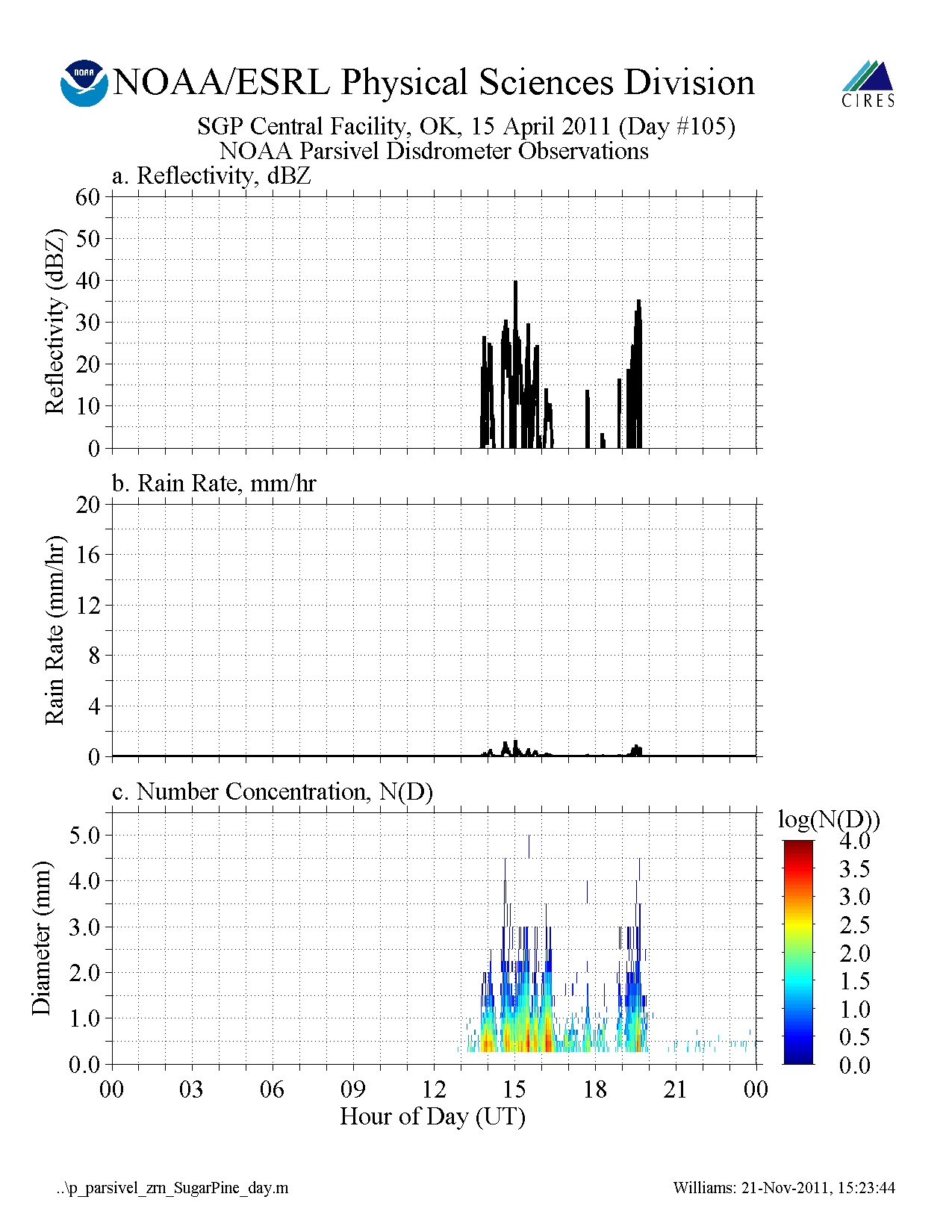
GPM GROUND VALIDATION NOAA PARSIVEL MC3E V1
National Aeronautics and Space Administration —
The GPM Ground Validation NOAA Parsivel MC3E dataset was collected in central Oklahoma during the Midlatitude Continental Convective Clouds Experiment (MC3E) from... -
Federal
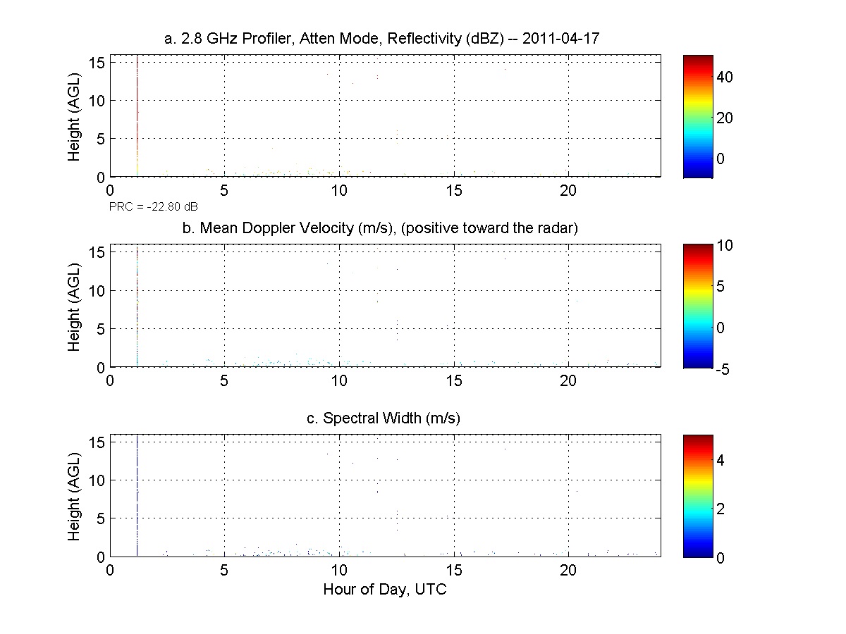
GPM GROUND VALIDATION NOAA S-BAND PROFILER ORIGINAL DWELL DATA MC3E V1
National Aeronautics and Space Administration —
The GPM Ground Validation NOAA S-Band Profiler Original Dwell Data MC3E dataset was gathered during the Midlatitude Continental Convective Clouds Experiment (MC3E) in... -
Federal
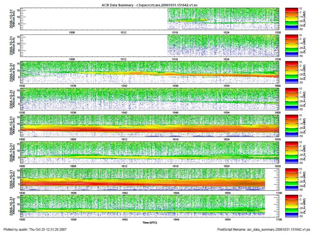
GPM Ground Validation NASA W-band Aircraft Cloud Radar (WACR) C3VP V1
National Aeronautics and Space Administration —
The GPM Ground Validation NASA W-band Airborne Cloud Radar (WACR) C3VP dataset consists of calibrated co- and cross-polarized radar reflectivity at 94 GHz during the... -
Federal
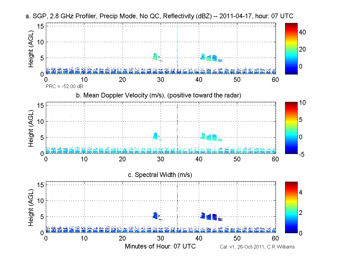
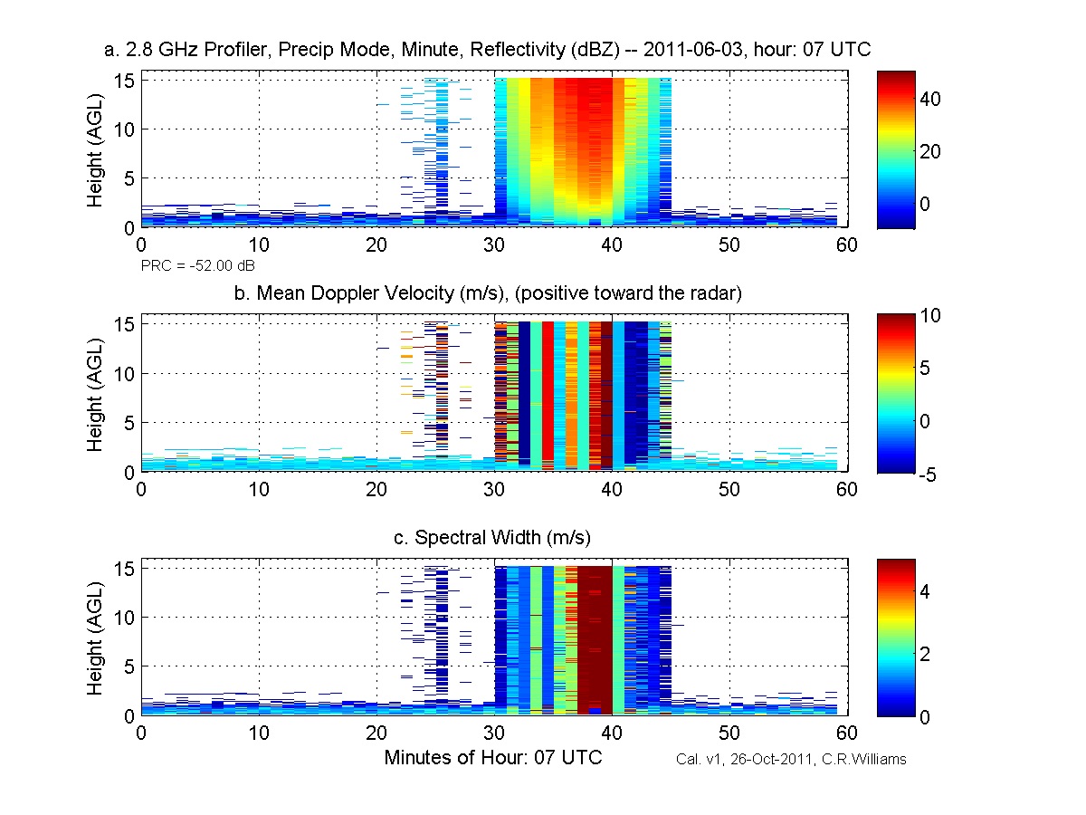
GPM GROUND VALIDATION NOAA S-BAND PROFILER MINUTE DATA MC3E V1
National Aeronautics and Space Administration —
The GPM Ground Validation NOAA S-Band Profiler Minute Data MC3E dataset was gathered during the Midlatitude Continental Convective Clouds Experiment (MC3E) in... -
Federal
SWOT Level 2 Radiometer Brightness Temperatures and Troposphere Interim Data Product Version 1.0
National Aeronautics and Space Administration —
The SWOT Level 2 Radiometer Brightness Temperatures and Troposphere Interim Geophysical Data Record (IGDR) Version 1.0 dataset produced by the Surface Water and Ocean...
11 datasets found