
-
Federal
AIRS/Aqua L1B Infrared (IR) geolocated and calibrated radiances V005 (AIRIBRAD) at GES DISC at GES DISC
National Aeronautics and Space Administration —
WARNING: On 2021/09/23 the EOS Aqua executed a Deep Space Maneuver (DSM). In the DSM, the spacecraft is turned such that the normal Earth field of regard is deep... -
Federal
AIRS/Aqua L1B Near Real Time (NRT) Infrared (IR) geolocated and calibrated radiances V005 (AIRIBRAD_NRT) at GES DISC
National Aeronautics and Space Administration —
WARNING: On 2021/09/23 the EOS Aqua executed a Deep Space Maneuver (DSM). In the DSM, the spacecraft is turned such that the normal Earth field of regard is deep... -
Federal
OCO-2 Level 1A collated, parsed, science or calibration data V11 (OCO2_L1aIn_Sample) at GES DISC
National Aeronautics and Space Administration —
Version 11 is the current version of the data set. Older versions will no longer be available and are superseded by Version 11. The Orbiting Carbon Observatory is the... -
Federal
OCO-3 Level 1B calibrated, geolocated science spectra, Retrospective Processing V10r (OCO3_L1B_Science) at GES DISC
National Aeronautics and Space Administration —
Version 10r is the current version of the data set. Older versions will no longer be available and are superseded by Version 10r. The Orbiting Carbon Observatory -3... -
Federal
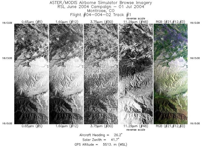
MASTER: Geological substrate mapping, Utah-Colorado, June, 2004
National Aeronautics and Space Administration —
This dataset includes Level 1B (L1B) data products from the MODIS/ASTER Airborne Simulator (MASTER) instrument. The spectral data were collected during two flights... -
Federal
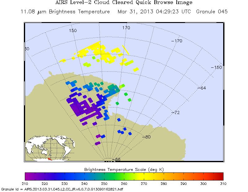
AIRS/Aqua L2 Cloud-Cleared Infrared Radiances (AIRS-only) V006 (AIRS2CCF) at GES DISC
National Aeronautics and Space Administration —
The Atmospheric Infrared Sounder (AIRS) is a grating spectrometer (R = 1200) aboard the second Earth Observing System (EOS) polar-orbiting platform, EOS Aqua. In... -
Federal
ASTER Level 1 Precision Terrain Corrected Registered At-Sensor Radiance V031 NGDA
National Aeronautics and Space Administration —
The Terra Advanced Spaceborne Thermal Emission and Reflection Radiometer (ASTER) Level 1 Precision Terrain Corrected Registered At-Sensor Radiance (AST_L1T) Version... -
Federal
OCO-2 Level 1B calibrated, geolocated science spectra, Retrospective Processing V10r (OCO2_L1B_Science) at GES DISC
National Aeronautics and Space Administration —
Version 10r is the current version of the data set. Older versions will no longer be available and are superseded by Version 10r. In early 2021, the OCO Team... -
Federal
MASTER: Costa Rica Airborne Research and Technology Applications (CARTA), 2005
National Aeronautics and Space Administration —
This dataset includes Level 1B (L1B) data products from the MODIS/ASTER Airborne Simulator (MASTER) instrument. The spectral data were collected during 23 flights... -
Federal
ASTER L2 Surface Radiance TIR V003 NGDA
National Aeronautics and Space Administration —
The ASTER Surface Radiance TIR (AST_09T) is generated (https://lpdaac.usgs.gov/documents/996/ASTER_Earthdata_Search_Order_Instructions.pdf) using the five Thermal... -
Federal
ASTER L2 Surface Radiance VNIR and SWIR V003 NGDA
National Aeronautics and Space Administration —
The ASTER Surface Radiance VNIR and SWIR (AST_09) is a multi-file product (https://lpdaac.usgs.gov/documents/996/ASTER_Earthdata_Search_Order_Instructions.pdf) that... -
Federal
S-MODE MASS Level 1 LWIR Version 1
National Aeronautics and Space Administration —
NOTICE: This dataset is currently undergoing maintenance to be repackaged as zip files of flight lines. The file count will decrease dramatically when new zip files... -
Federal
MASTER: California Fires, California, November 2007
National Aeronautics and Space Administration —
This dataset includes Level 1B (L1B) data products from the MODIS/ASTER Airborne Simulator (MASTER) instrument. The spectral data were collected during six flights... -
Federal
ASTER Registered Radiance at the Sensor - Orthorectified V003 NGDA
National Aeronautics and Space Administration —
The ASTER Orthorectified Registered Radiance at the Sensor (AST14OTH) product (https://lpdaac.usgs.gov/documents/618/ASTER_Earthdata_Search_Order_Instructions.pdf)... -
Federal
MASTER: HyspIRI Airborne Campaign, California, Spring 2015
National Aeronautics and Space Administration —
This dataset includes Level 1B (L1B) and Level 2 (L2) data products from the MODIS/ASTER Airborne Simulator (MASTER) instrument. The spectral data were collected as... -
Federal
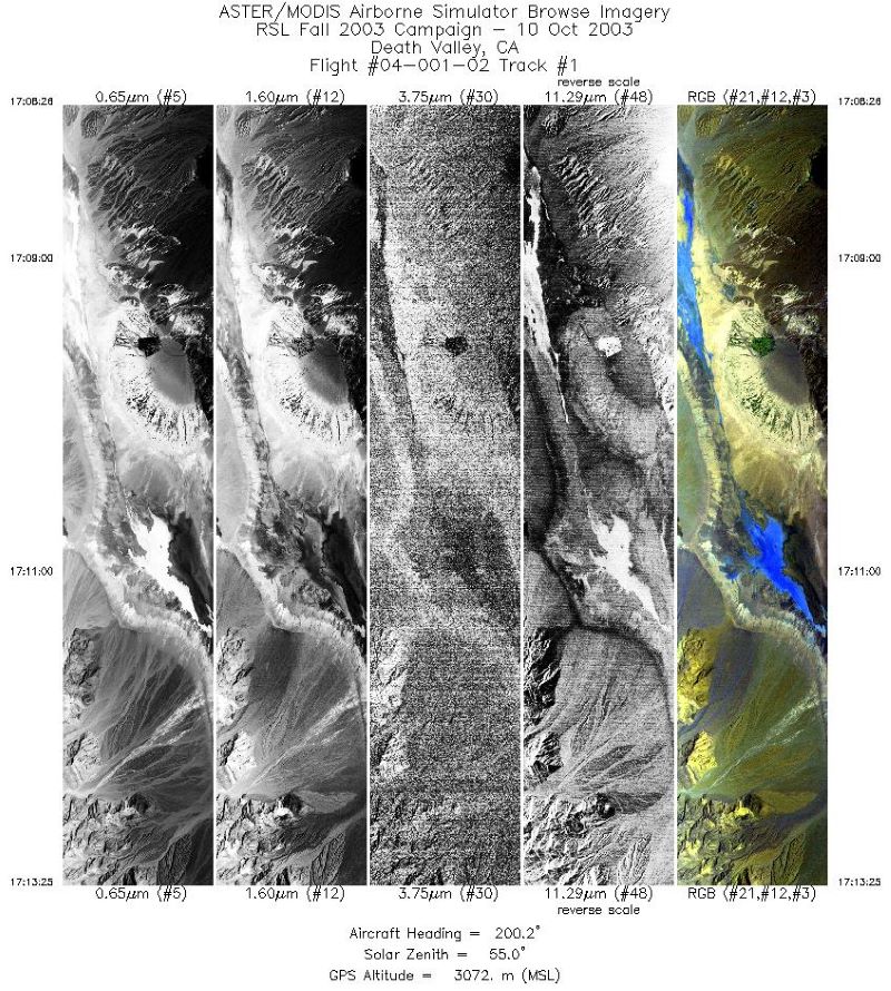
MASTER: Geological fault mapping, California-Nevada, October, 2003
National Aeronautics and Space Administration —
This dataset includes Level 1B (L1B) data products from the MODIS/ASTER Airborne Simulator (MASTER) instrument. The spectral data were collected during six flights... -
Federal
MASTER: FIREX-AQ Airborne Campaign, Western-Central USA, Summer 2019
National Aeronautics and Space Administration —
This dataset includes Level 1B (L1B) and Level 2 (L2) data products from the MODIS/ASTER Airborne Simulator (MASTER) instrument. The spectral data were collected as... -
Federal
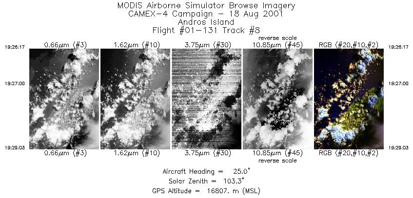
CAMEX-4 ER-2 MODIS AIRBORNE SIMULATOR (MAS) V1
National Aeronautics and Space Administration —
The MODIS Airborne Simulator (MAS) is an airborne scanning spectrometer that acquires high spatial resolution imagery of cloud and surface features from its vantage... -
Federal
OMPS-NPP L1G LP Radiance EV Wavelength-Altitude Grid swath orbital 3slit V2.6 (OMPS_NPP_LP_L1G_EV) at GES DISC
National Aeronautics and Space Administration —
The OMPS-NPP L1G LP Radiance EV Wavelength-Altitude Grid swath orbital 3slit product contains the calibrated earth-viewing radiances measured by the Ozone Mapping and...

Official websites use .gov
A
.gov website belongs to an official government
organization in the United States.
Secure .gov websites use HTTPS
A
lock (
) or https:// means you’ve safely connected to
the .gov website. Share sensitive information only on official,
secure websites.