
-
Federal
CRED Cumulative Map of Percent Scleractinian Coral Cover at Zealandia
National Oceanic and Atmospheric Administration, Department of Commerce —
This map displays optical validation observation locations and percent coverage of scleractinian coral overlaid on bathymetry. -
Federal
CRED Cumulative Map of Percent Scleractinian Coral Cover at Arakane
National Oceanic and Atmospheric Administration, Department of Commerce —
This map displays optical validation observation locations and percent coverage of scleractinian coral overlaid on bathymetry. -
Federal
CRED Cumulative Map of Percent Scleractinian Coral Cover at Pearl and Hermes Atoll, 2002-2004
National Oceanic and Atmospheric Administration, Department of Commerce —
This map displays optical validation observation locations and percent coverage of scleractinian coral overlaid on bathymetry. -
Federal
CRED Cumulative Map of Percent Scleractinian Coral Cover at Johnston Atoll, 2004
National Oceanic and Atmospheric Administration, Department of Commerce —
This map displays optical validation observation locations and percent coverage of scleractinian coral overlaid on bathymetry. -
Federal
CRED Cumulative Map of Percent Scleractinian Coral Cover at Ofu & Olosega
National Oceanic and Atmospheric Administration, Department of Commerce —
This map displays optical validation observation locations and percent coverage of scleractinian coral overlaid on bathymetry. -
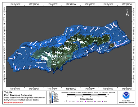
Federal
CRED Cumulative Fish Biomass map at Tutuila Island
National Oceanic and Atmospheric Administration, Department of Commerce —
This map displays fish biomass observation locations overlaid on bathymetry. -
Federal
Recovery of Queen Conch in the U. S. Virgin Islands
National Oceanic and Atmospheric Administration, Department of Commerce —
The queen conch is an important cultural component and an extremely valuable coral reef fishery resource throughout the Caribbean, historically second only to the... -
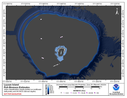
Federal
CRED Fish Biomass Estimates map at Laysan Island
National Oceanic and Atmospheric Administration, Department of Commerce —
This map displays fish biomass observation locations overlaid on bathymetry -
Federal
CRED Cumulative Map of Percent Scleractinian Coral Cover at Agrihan
National Oceanic and Atmospheric Administration, Department of Commerce —
This map displays optical validation observation locations and percent coverage of scleractinian coral overlaid on bathymetry. -
Federal
CRED Cumulative Map of Percent Scleractinian Coral Cover at Guam, 2003
National Oceanic and Atmospheric Administration, Department of Commerce —
This map displays optical validation observation locations and percent coverage of scleractinian coral overlaid on bathymetry. -
Federal
CRED Cumulative Map of Percent Scleractinian Coral Cover at Baker Island, 2002-2004
National Oceanic and Atmospheric Administration, Department of Commerce —
This map displays optical validation observation locations and percent coverage of scleractinian coral overlaid on bathymetry. -
Federal
CRED Cumulative Map of Percent Scleractinian Coral Cover at Niihau, 2005
National Oceanic and Atmospheric Administration, Department of Commerce —
This map displays optical validation observation locations and percent coverage of scleractinian coral overlaid on bathymetry. -
Federal
CRED Cumulative Map of Percent Scleractinian Coral Cover at Aguijan
National Oceanic and Atmospheric Administration, Department of Commerce —
This map displays optical validation observation locations and percent coverage of scleractinian coral overlaid on bathymetry. -
Federal
CRED Cumulative Map of Percent Scleractinian Coral Cover at Kure Atoll, 2002-2004
National Oceanic and Atmospheric Administration, Department of Commerce —
This map displays optical validation observation locations and percent coverage of scleractinian coral overlaid on bathymetry. -
Federal
CRED Cumulative Map of Percent Scleractinian Coral Cover at Farallon de Pajaros (Uracas)
National Oceanic and Atmospheric Administration, Department of Commerce —
This map displays optical validation observation locations and percent coverage of scleractinian coral overlaid on bathymetry. -
Federal
CRED Cumulative Map of Percent Scleractinian Coral Cover at Howland Island, 2002-2004
National Oceanic and Atmospheric Administration, Department of Commerce —
This map displays optical validation observation locations and percent coverage of scleractinian coral overlaid on bathymetry. -
Federal
CRED Cumulative Map of Percent Scleractinian Coral Cover at Asuncion
National Oceanic and Atmospheric Administration, Department of Commerce —
This map displays optical validation observation locations and percent coverage of scleractinian coral overlaid on bathymetry. -
Federal
Predicted Habitat Suitability for Montipora in the Au'au Channel Region
National Oceanic and Atmospheric Administration, Department of Commerce —
This raster denotes predicted habitat suitability for Montipora in the Auau Channel region. Maximum Entropy (MaxEnt) modeling software was used to create this... -
Federal
CRED Cumulative Map of Percent Scleractinian Coral Cover at Kauai, 2005
National Oceanic and Atmospheric Administration, Department of Commerce —
This map displays optical validation observation locations and percent coverage of scleractinian coral overlaid on bathymetry. -
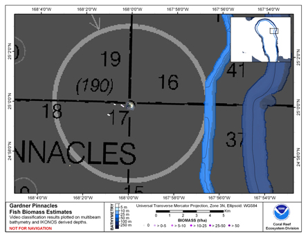
Federal
CRED Cumulative Fish Biomass Estimates Map at Gardner Pinnacles
National Oceanic and Atmospheric Administration, Department of Commerce —
This map displays fish biomass observation locations overlaid on bathymetry.

Official websites use .gov
A
.gov website belongs to an official government
organization in the United States.
Secure .gov websites use HTTPS
A
lock (
) or https:// means you’ve safely connected to
the .gov website. Share sensitive information only on official,
secure websites.