
-
Federal
HANPP Collection: Human Appropriation of Net Primary Productivity as a Percentage of Net Primary Productivity
National Aeronautics and Space Administration —
The HANPP Collection: Human Appropriation of Net Primary Productivity as a Percentage of Net Primary Productivity represents a map identifying regions in which human... -
Federal
Global Man-made Impervious Surface (GMIS) Dataset From Landsat
National Aeronautics and Space Administration —
The Global Man-made Impervious Surface (GMIS) Dataset From Landsat consists of global estimates of fractional impervious cover derived from the Global Land Survey... -
Federal
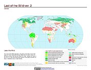
Last of the Wild Project, Version 2, 2005 (LWP-2): Global Human Footprint Dataset (Geographic)
National Aeronautics and Space Administration —
The Global Human Footprint Dataset of the Last of the Wild Project, Version 2, 2005 (LWP-2) is the Human Influence Index (HII) normalized by biome and realm. The HII... -
Federal
Compendium of Environmental Sustainability Indicator Collections: The Wellbeing of Nations
National Aeronautics and Space Administration —
The Wellbeing of Nations portion of the Compendium of Environmental Sustainability Indicator Collections contains a subset of 123 variables assembled from the... -
Federal
Last of the Wild Project, Version 1, 2002 (LWP-1): Last of the Wild Dataset (Geographic)
National Aeronautics and Space Administration —
The Last of the Wild Dataset of the Last of the Wild Project, Version 1, 2002 (LWP-1) is derived from the LWP-1 Human Footprint Dataset. The gridded data are... -
Federal
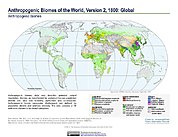
Anthropogenic Biomes of the World, Version 2: 1700
National Aeronautics and Space Administration —
The Anthropogenic Biomes of the World, Version 2: 1700 data set describes anthropogenic transformations within the terrestrial biosphere caused by sustained direct... -
Federal
Last of the Wild Project, Version 3 (LWP-3): 2009 Human Footprint, 2018 Release
National Aeronautics and Space Administration —
The 2009 Human Footprint, 2018 Release provides a global map of the cumulative human pressure on the environment in 2009, at a spatial resolution of ~1 km. The human... -
Federal
CRED Optical Validation Data at the island of Ta'u in American Samoa, 2012 to support Benthic Habitat Mapping (TOAD)
National Oceanic and Atmospheric Administration, Department of Commerce —
Optical validation data were collected using the Tethered Optical Assessment Device (TOAD), a sled equipped with underwater video camera, still camera and lights.... -
Federal
Last of the Wild Project, Version 2, 2005 (LWP-2): Last of the Wild Dataset (Geographic)
National Aeronautics and Space Administration —
The Last of the Wild Dataset of the Last of the Wild Project, Version 2, 2005 (LWP-2) is derived from the LWP-2 Human Footprint Dataset. The gridded data are... -
Federal
Anthropogenic Biomes of the World, Version 2: 1800
National Aeronautics and Space Administration —
The Anthropogenic Biomes of the World, Version 2: 1800 data set describes anthropogenic transformations within the terrestrial biosphere caused by sustained direct... -
Federal
Last of the Wild Project, Version 2, 2005 (LWP-2): Global Human Footprint Dataset (IGHP)
National Aeronautics and Space Administration —
The Global Human Footprint Dataset of the Last of the Wild Project, Version 2, 2005 (LWP-2) is the Human Influence Index (HII) normalized by biome. The HII is a... -
Federal
Global Human Modification of Terrestrial Systems
National Aeronautics and Space Administration —
The Global Human Modification of Terrestrial Systems data set provides a cumulative measure of the human modification of terrestrial lands across the globe at a 1-km... -
Federal
Last of the Wild Project, Version 1, 2002 (LWP-1): Top One Percent Wild Areas Dataset (Geographic)
National Aeronautics and Space Administration —
The Top One Percent Wild Areas Dataset of the Last of the Wild Project, Version 1, 2002 (LWP-1) is derived from the LWP-1 Human Footprint Dataset. The gridded data... -
Federal
China Dimensions Data Collection: China Maps Bibliographic Database
National Aeronautics and Space Administration —
The China Maps Bibliographic Database is an historical collection of bibliographic information for more than 400 maps of China. The information resides in a... -
Federal
HANPP Collection: Global Patterns in Human Appropriation of Net Primary Productivity (HANPP)
National Aeronautics and Space Administration —
The HANPP Collection: Global Patterns in Human Appropriation of Net Primary Productivity (HANPP) represents a digital map of human appropriation of net primary... -
Federal
Mosaic of bathymetry derived from multispectral World View-2 satellite imagery of Sarigan Island, Territory of Territory of Mariana, USA.
National Oceanic and Atmospheric Administration, Department of Commerce —
Bathymetric data derived from a multipectral World View-2 satellite image mosaiced to provide near complete coverage of nearshore terrain around the islands.... -
Federal
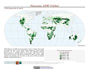
Global Agricultural Lands: Pastures, 2000
National Aeronautics and Space Administration —
The Global Pastures data set represents the proportion of land areas used as pasture land (land used to support grazing animals) in the year 2000. Satellite data from... -
Federal
Global Agricultural Lands: Croplands, 2000
National Aeronautics and Space Administration —
The Global Croplands data set represents the proportion of land areas used as cropland (land used for the cultivation of food) in the year 2000. Satellite data from...

Official websites use .gov
A
.gov website belongs to an official government
organization in the United States.
Secure .gov websites use HTTPS
A
lock (
) or https:// means you’ve safely connected to
the .gov website. Share sensitive information only on official,
secure websites.