
-
Federal
SPURS-2 Passive Accoustic Listener (PAL) data from ARGO float deployments during the E. Tropical Pacific field campaign
National Aeronautics and Space Administration —
The SPURS (Salinity Processes in the Upper Ocean Regional Study) project is a NASA-funded oceanographic process study and associated field program that aim to... -
Federal
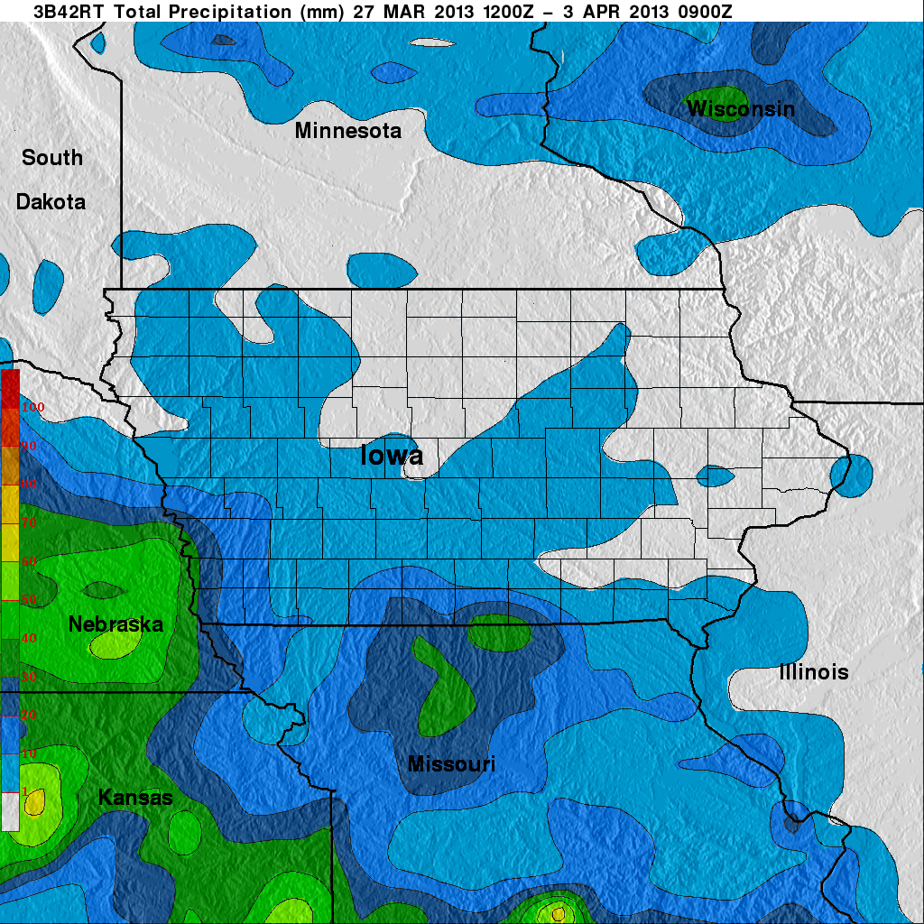
GPM Ground Validation TRMM Multi-satellite Precipitation Analysis (TMPA) IFloodS V7
National Aeronautics and Space Administration —
The GPM Ground Validation TRMM Multi-satellite Precipitation Analysis (TMPA) IFloodS dataset is a subset of the TMPA 3B42RT gridded precipitation real-time product... -
Federal
ABoVE: Dall Sheep Lamb Recruitment and Climate Data, Alaska and NW Canada, 2000-2015 NGDA
National Aeronautics and Space Administration —
This dataset contains estimated annual average Dall sheep (Ovis dalli dalli) lamb-to-ewe ratios for each year from 2000-2015 across the full species range in Alaska... -
Federal
SPURS-2 research vessel along track SEA-POL rain radar imaging data for E. Tropical Pacific R/V Revelle-2 cruise
National Aeronautics and Space Administration —
The SPURS (Salinity Processes in the Upper Ocean Regional Study) project is NASA-funded oceanographic process study and associated field program that aim to elucidate... -
Federal
ECCO Ocean and Sea-Ice Surface Freshwater Fluxes - Monthly Mean 0.5 Degree (Version 4 Release 4)
National Aeronautics and Space Administration —
This dataset contains monthly-averaged ocean and sea-ice surface freshwater fluxes interpolated to a regular 0.5-degree grid from the ECCO Version 4 revision 4 (V4r4)... -
Federal
Characteristics of African Savanna Biomes for Determining Woody Cover
National Aeronautics and Space Administration —
This data set includes the soil and vegetation characteristics, herbivore estimates, and precipitation measurement data for the 854 sites described and analyzed in... -
Federal
Airborne Precipitation Radar 3rd Generation (APR-3) CPEX-AW V1
National Aeronautics and Space Administration —
The Airborne Precipitation Radar 3rd Generation (APR-3) CPEX-AW dataset consists of radar reflectivity, Doppler velocity for all bands, linear depolarization ratio... -
Federal
ECCO Ocean and Sea-Ice Surface Freshwater Fluxes - Monthly Mean llc90 Grid (Version 4 Release 4)
National Aeronautics and Space Administration —
This dataset provides monthly-averaged ocean and sea-ice surface freshwater fluxes on the native Lat-Lon-Cap 90 (LLC90) model grid from the ECCO Version 4 Release 4... -
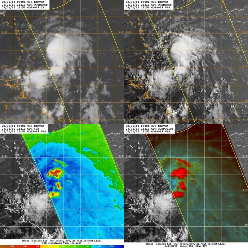
Federal
Hurricane and Severe Storm Sentinel (HS3) Naval Research Laboratory (NRL) Tropics Satellite Data V1
National Aeronautics and Space Administration —
The Hurricane and Severe Storm Sentinel (HS3) Naval Research Laboratory (NRL) Tropics Satellite Data contains browse only data files, including brightness... -
Federal
FLUXNET Research Network Site Characteristics, Investigators, and Bibliography, 2016
National Aeronautics and Space Administration —
FLUXNET is a global network of micrometeorological tower sites that use eddy covariance methods to measure the exchanges of carbon dioxide, water vapor, and energy... -
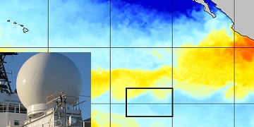
Federal
Remote Sensing Systems Radiometer Rain Collocations with JPL RapidScat L2B Swath Grid
National Aeronautics and Space Administration —
This dataset contains the multi-sourced microwave radiometer wind speed, rain and cloud liquid water data collocated to RapidScat Level 2B wind vector cell (WVC)... -
Federal
GPM Ground Validation Global Satellite Mapping of Precipitation (GSMaP) IFloodS V1
National Aeronautics and Space Administration —
The GPM Ground Validation Global Satellite Mapping of Precipitation (GSMaP) IFloodS dataset consists of rainfall rate estimates from the GSMaP project. The GSMaP... -
Federal
GPM Ground Validation Global Flood Monitoring System (GFMS) Flood Maps IFloodS V1
National Aeronautics and Space Administration —
The GPM Ground Validation Global Flood Monitoring System (GFMS) Flood Maps IFloodS dataset contains global flood estimates on a 0.25 degree spatial resolution every 3... -
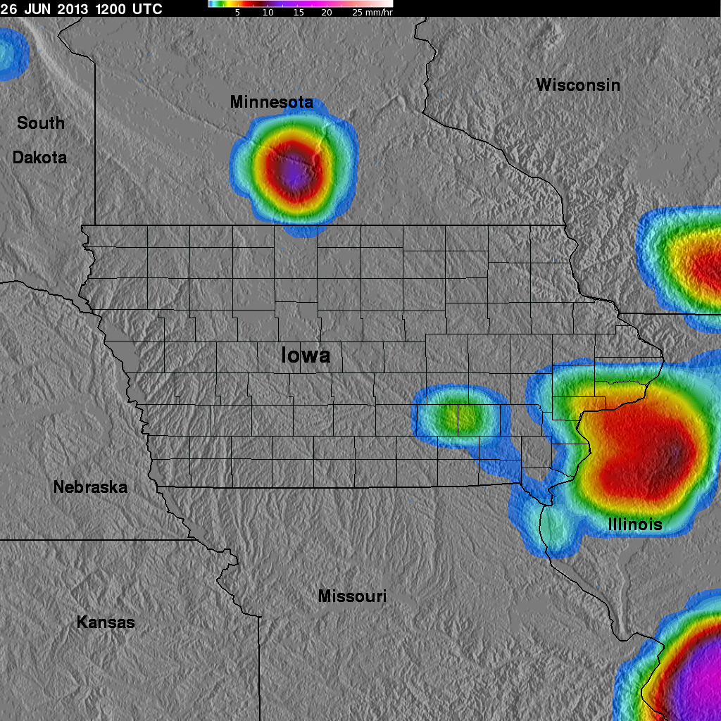
Federal
GPM Ground Validation Naval Research Laboratory (NRL) Near-Real Time Rain Rates IFloodS V1
National Aeronautics and Space Administration —
The GPM Ground Validation Naval Research Laboratory (NRL) Near-Real Time Rain Rates IFloodS data product was created for the GPM Iowa Flood Studies (IFloodS) field... -
Federal
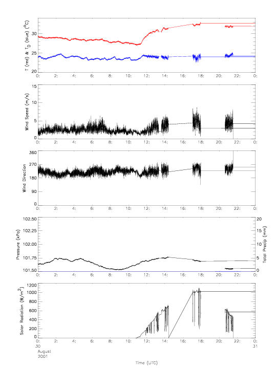
CAMEX-4 MIPS SURFACE STATION 2 V1
National Aeronautics and Space Administration —
The University of Alabama in Huntsville (UAH) Mobile Integrated Profiling System (MIPS) is a mobile atmospheric profiling system. It includes a 915 MHz Doppler... -
Federal
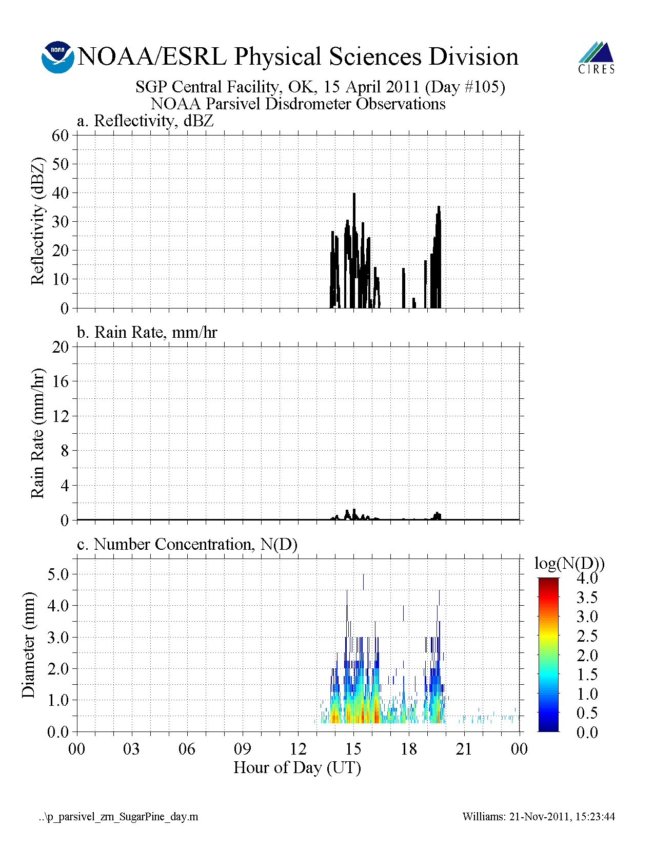
GPM GROUND VALIDATION NOAA PARSIVEL MC3E V1
National Aeronautics and Space Administration —
The GPM Ground Validation NOAA Parsivel MC3E dataset was collected in central Oklahoma during the Midlatitude Continental Convective Clouds Experiment (MC3E) from... -
Federal
SPURS-1 research vessel Meteorological series data for N. Atlantic Endeavor cruises
National Aeronautics and Space Administration —
The SPURS (Salinity Processes in the Upper Ocean Regional Study) project is an oceanographic process study and associated field program that aim to elucidate key... -
Federal
GRIP HURRICANE IMAGING RADIOMETER (HIRAD) V0
National Aeronautics and Space Administration —
The GRIP Hurricane Imaging Radiometer (HIRAD) dataset was collected by the HIRAD instrument, which is a hurricane imaging, single-polarization passive C-band... -
Federal
CAMEX-4 MIPS SURFACE STATION 1 V1
National Aeronautics and Space Administration —
The University of Alabama in Huntsville (UAH) Mobile Integrated Profiling System (MIPS) is a mobile atmospheric profiling system. It includes a 915 MHz Doppler... -
Federal
SPURS-2 Research vessel Meteorological series data for the E. Tropical Pacific field campaign R/V Revelle cruises
National Aeronautics and Space Administration —
The SPURS (Salinity Processes in the Upper Ocean Regional Study) project is a NASA-funded oceanographic process study and associated field program that aim to...

Official websites use .gov
A
.gov website belongs to an official government
organization in the United States.
Secure .gov websites use HTTPS
A
lock (
) or https:// means you’ve safely connected to
the .gov website. Share sensitive information only on official,
secure websites.