
-
Federal
CRED Cumulative Map of Percent Scleractinian Coral Cover at Molokai, 2005
National Oceanic and Atmospheric Administration, Department of Commerce —
This map displays optical validation observation locations and percent coverage of scleractinian coral overlaid on bathymetry. -
Federal
CRED Cumulative Map of Percent Scleractinian Coral Cover at Kauai, 2005
National Oceanic and Atmospheric Administration, Department of Commerce —
This map displays optical validation observation locations and percent coverage of scleractinian coral overlaid on bathymetry. -
Federal
CRED Cumulative Map of Percent Scleractinian Coral Cover at Pearl and Hermes Atoll, 2002-2004
National Oceanic and Atmospheric Administration, Department of Commerce —
This map displays optical validation observation locations and percent coverage of scleractinian coral overlaid on bathymetry. -
Federal
CRED Cumulative Map of Percent Scleractinian Coral Cover at Oahu, 2005
National Oceanic and Atmospheric Administration, Department of Commerce —
This map displays optical validation observation locations and percent coverage of scleractinian coral overlaid on bathymetry. -
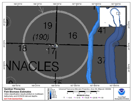
Federal
CRED Cumulative Fish Biomass Estimates Map at Gardner Pinnacles
National Oceanic and Atmospheric Administration, Department of Commerce —
This map displays fish biomass observation locations overlaid on bathymetry. -
Federal
CRED Cumulative Map of Percent Scleractinian Coral Cover at St. Rogatien West, 2001
National Oceanic and Atmospheric Administration, Department of Commerce —
This map displays optical validation observation locations and percent coverage of scleractinian coral overlaid on bathymetry. -
Federal
CRED Cumulative Map of Percent Scleractinian Coral Cover at Gardner Pinnacles, 2003
National Oceanic and Atmospheric Administration, Department of Commerce —
This map displays optical validation observation locations and percent coverage of scleractinian coral overlaid on bathymetry. -
Federal
CRED Cumulative Map of Percent Scleractinian Coral Cover at Necker Island, 2002-2004
National Oceanic and Atmospheric Administration, Department of Commerce —
This map displays optical validation observation locations and percent coverage of scleractinian coral overlaid on bathymetry. -
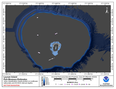
Federal
CRED Fish Biomass Estimates map at Laysan Island
National Oceanic and Atmospheric Administration, Department of Commerce —
This map displays fish biomass observation locations overlaid on bathymetry -
Federal
CRED Cumulative Map of Percent Scleractinian Coral Cover at Midway Atoll, 2002-04
National Oceanic and Atmospheric Administration, Department of Commerce —
This map displays optical validation observation locations and percent coverage of scleractinian coral overlaid on bathymetry. -
Federal
CRED Cumulative Map of Percent Scleractinian Coral Cover at Lisianski Island, 2001-2004
National Oceanic and Atmospheric Administration, Department of Commerce —
This map displays optical validation observation locations and percent coverage of scleractinian coral overlaid on bathymetry. -
Federal
CRED Cumulative Map of Percent Scleractinian Coral Cover at Kure Atoll, 2002-2004
National Oceanic and Atmospheric Administration, Department of Commerce —
This map displays optical validation observation locations and percent coverage of scleractinian coral overlaid on bathymetry. -
Federal
CRED Cumulative Map of Percent Scleractinian Coral Cover at Laysan Island, 2002-2004
National Oceanic and Atmospheric Administration, Department of Commerce —
This map displays optical validation observation locations and percent coverage of scleractinian coral overlaid on bathymetry. -
Federal
CRED Cumulative Map of Percent Scleractinian Coral Cover at Niihau, 2005
National Oceanic and Atmospheric Administration, Department of Commerce —
This map displays optical validation observation locations and percent coverage of scleractinian coral overlaid on bathymetry. -
Federal
CRED Fish Biomass Estimates map at Pearl and Hermes Atoll.
National Oceanic and Atmospheric Administration, Department of Commerce —
This map displays fish biomass observation locations overlaid on bathymetry. -
Federal
CRED Cumulative Map of Percent Scleractinian Coral Cover at French Frigate Shoals
National Oceanic and Atmospheric Administration, Department of Commerce —
This map displays optical validation observation locations and percent coverage of scleractinian coral overlaid on bathymetry. -
Federal
CRED Cumulative Map of Percent Scleractinian Coral Cover at Raita Bank, 2001
National Oceanic and Atmospheric Administration, Department of Commerce —
This map displays optical validation observation locations and percent coverage of scleractinian coral overlaid on bathymetry. -
Federal
CRED Cumulative Map of Percent Scleractinian Coral Cover at Maro Reef, 2001-2004
National Oceanic and Atmospheric Administration, Department of Commerce —
This map displays optical validation observation locations and percent coverage of scleractinian coral overlaid on bathymetry.

Official websites use .gov
A
.gov website belongs to an official government
organization in the United States.
Secure .gov websites use HTTPS
A
lock (
) or https:// means you’ve safely connected to
the .gov website. Share sensitive information only on official,
secure websites.