
-
Federal
Matagorda Bay, TX (G280) Bathymetric Digital Elevation Model (30 meter resolution) Derived From Source Hydrographic Survey Soundings Collected by NOAA
National Oceanic and Atmospheric Administration, Department of Commerce —
Bathymetry for Matagorda Bay was derived from twenty-three surveys containing 250,396 soundings. Six overlapping, older, less accurate surveys were omitted, and the... -
Federal
F00699: NOS Hydrographic Survey , Mississippi Sound and Vicinity, 2017-09-06
National Oceanic and Atmospheric Administration, Department of Commerce —
The National Oceanic and Atmospheric Administration (NOAA) has the statutory mandate to collect hydrographic data in support of nautical chart compilation for safe... -
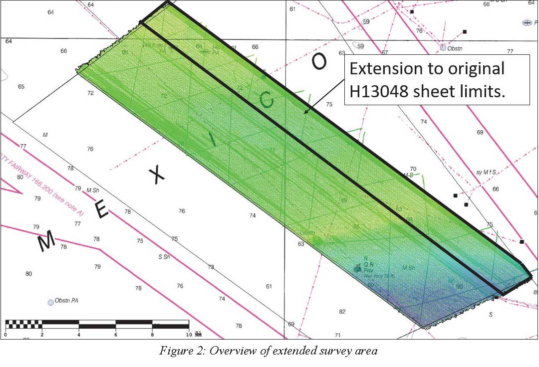
Federal
H13048: NOS Hydrographic Survey , 2018-08-07
National Oceanic and Atmospheric Administration, Department of Commerce —
The National Oceanic and Atmospheric Administration (NOAA) has the statutory mandate to collect hydrographic data in support of nautical chart compilation for safe... -
Federal
Subbottom Profiler Collection for EX1402L1: Gulf of Mexico Mapping and Exploration
National Oceanic and Atmospheric Administration, Department of Commerce —
Knudsen CHIRP 3260 Sub-bottom Profiler raw files (.sgy) -
Federal
H13218: NOS Hydrographic Survey , 2019-09-21
National Oceanic and Atmospheric Administration, Department of Commerce —
The National Oceanic and Atmospheric Administration (NOAA) has the statutory mandate to collect hydrographic data in support of nautical chart compilation for safe... -
Federal
H12763: NOS Hydrographic Survey , 2015-08-12
National Oceanic and Atmospheric Administration, Department of Commerce —
The National Oceanic and Atmospheric Administration (NOAA) has the statutory mandate to collect hydrographic data in support of nautical chart compilation for safe... -
Federal
Subbottom Profiler Collection for EX1402L2: Gulf of Mexico Mapping and Exploration
National Oceanic and Atmospheric Administration, Department of Commerce —
Knudsen CHIRP 3260 Sub-bottom Profiler raw files (.sgy) -
Federal
Near-real-time surface ocean velocities derived from HF-radar stations located along coastal waters of North Slope Alaska, Gulf of Alaska, Puerto Rico/Virgin Islands, eastern U.S./Gulf of America, Hawaii, Great Lakes, and western U.S.
National Oceanic and Atmospheric Administration, Department of Commerce —
This dataset contains near-real-time ocean surface velocities, also known as total vector velocities, derived from high-frequency (HF) radar stations. The velocities... -
Federal
F00698: NOS Hydrographic Survey , 2017-09-05
National Oceanic and Atmospheric Administration, Department of Commerce —
The National Oceanic and Atmospheric Administration (NOAA) has the statutory mandate to collect hydrographic data in support of nautical chart compilation for safe... -
Federal
H13183: NOS Hydrographic Survey , 2019-02-06
National Oceanic and Atmospheric Administration, Department of Commerce —
The National Oceanic and Atmospheric Administration (NOAA) has the statutory mandate to collect hydrographic data in support of nautical chart compilation for safe... -
Federal
Surface ocean radial velocities obtained by HF-radar from stations located along coastal waters of Hawaii, North Slope Alaska, Gulf of Alaska, Puerto Rico/Virgin Islands, eastern U.S./Gulf of America, western U.S., and the Great Lakes
National Oceanic and Atmospheric Administration, Department of Commerce —
This dataset contains surface ocean radial velocities data obtained by HF-radar from stations located along coastal waters of the United States. Radial velocity files... -
Federal
F00734: NOS Hydrographic Survey , 2019-02-07
National Oceanic and Atmospheric Administration, Department of Commerce —
The National Oceanic and Atmospheric Administration (NOAA) has the statutory mandate to collect hydrographic data in support of nautical chart compilation for safe... -
Federal
H13219: NOS Hydrographic Survey , 2019-09-23
National Oceanic and Atmospheric Administration, Department of Commerce —
The National Oceanic and Atmospheric Administration (NOAA) has the statutory mandate to collect hydrographic data in support of nautical chart compilation for safe... -
Federal
H13703: NOS Hydrographic Survey , 2023-06-29
National Oceanic and Atmospheric Administration, Department of Commerce —
The National Oceanic and Atmospheric Administration (NOAA) has the statutory mandate to collect hydrographic data in support of nautical chart compilation for safe... -
Federal
D00263: NOS Hydrographic Survey , 2018-12-18
National Oceanic and Atmospheric Administration, Department of Commerce —
The National Oceanic and Atmospheric Administration (NOAA) has the statutory mandate to collect hydrographic data in support of nautical chart compilation for safe... -
Federal
Resource Analysis for Deep Direct-Use Feasibility Study in East Texas, Part 2
Department of Energy —
The National Renewable Energy Laboratory, Southern Methodist University Geothermal Laboratory, Eastman Chemical, Turbine Air Systems, and the Electric Power Research... -
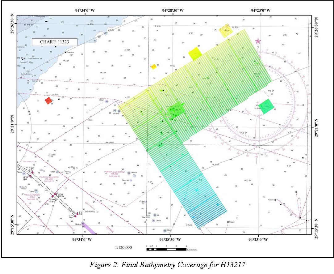
Federal
H13217: NOS Hydrographic Survey , 2019-09-20
National Oceanic and Atmospheric Administration, Department of Commerce —
The National Oceanic and Atmospheric Administration (NOAA) has the statutory mandate to collect hydrographic data in support of nautical chart compilation for safe... -
Federal
D00220: NOS Hydrographic Survey , 2016-11-01
National Oceanic and Atmospheric Administration, Department of Commerce —
The National Oceanic and Atmospheric Administration (NOAA) has the statutory mandate to collect hydrographic data in support of nautical chart compilation for safe... -
Federal
F00880: NOS Hydrographic Survey , 2023-06-24
National Oceanic and Atmospheric Administration, Department of Commerce —
The National Oceanic and Atmospheric Administration (NOAA) has the statutory mandate to collect hydrographic data in support of nautical chart compilation for safe... -
Federal
F00812: NOS Hydrographic Survey , 2020-08-30
National Oceanic and Atmospheric Administration, Department of Commerce —
The National Oceanic and Atmospheric Administration (NOAA) has the statutory mandate to collect hydrographic data in support of nautical chart compilation for safe...

Official websites use .gov
A
.gov website belongs to an official government
organization in the United States.
Secure .gov websites use HTTPS
A
lock (
) or https:// means you’ve safely connected to
the .gov website. Share sensitive information only on official,
secure websites.