
-
State
Hospital Annual Financial Data - Selected Data & Pivot Tables 23 recent views
State of California —
On an annual basis (individual hospital fiscal year), individual hospitals and hospital systems report detailed facility-level data on services capacity,... -
Federal
15 Minute Stream Flow Data: USGS (FIFE)
National Aeronautics and Space Administration —
USGS 15 minute stream flow data for Kings Creek on the Konza Prairie -
Federal
UARS High Resolution Doppler Imager (HRDI) Level 3AL V011 (UARHR3AL) at GES DISC
National Aeronautics and Space Administration —
The High Resolution Doppler Imager (HRDI) Level 3AL data product consists of daily, 4 degree increment latitude-ordered vertical profiles of meridional and zonal wind... -
Federal
MHK Levelized Cost of Energy (LCOE) Guidance and Techo Economic Analysis Materials
Department of Energy —
Useful information and tools for calculating the Levelized Cost of Energy (LCOE) and MHK Cost Breakdown Structure. Includes a structure for calculating the capital... -
Federal
Vegetation Species Reference (FIFE)
National Aeronautics and Space Administration —
LTER species names, codes, types, and other reference information -
State
Hospital Annual Utilization Report & Pivot Tables
State of California —
On an annual basis (individual hospital fiscal year), individual hospitals and hospital systems report detailed facility-level data. The complete Data Set of annual... -
Federal
UARS Correlative NMC Daily Gridded Stratospheric Assimilated Data V001 (UARZCNMC) at GES DISC
National Aeronautics and Space Administration —
The UARS Correlative assimilation data from NOAA's National Meteorological Center (NMC) consists of daily model runs at 12 GMT as a means of providing an independent... -
State
Hospital Annual Financial Disclosure Report – Complete Data Set
State of California —
On an annual basis (individual hospital fiscal year), individual hospitals and hospital systems report detailed facility-level data on services capacity,... -
Federal
30 Minute Rainfall Data (FIFE)
National Aeronautics and Space Administration —
30 minute rainfall data for the Konza Prairie -
Federal
Deep Direct-Use Feasibility Study Development of 3-D Structural Surface Model for the Tuscarora Sandstone, Morgantown, WV
Department of Energy —
This dataset contains grid files for subsurface maps created in GES interpretation software and exported as Zmap formated grid files. Depth values in SSTVD (subsea... -
Federal
UARS Solar Ultraviolet Spectral Irradiance Monitor (SUSIM) Level 3BS V022 (UARSU3BS) at GES DISC
National Aeronautics and Space Administration —
The Solar Ultraviolet Spectral Irradiance Monitor (SUSIM) Level 3BS data product consists of daily, 1 nm resolution, solar spectral irradiances and selected solar... -
State
Primary Care Clinic Annual Utilization Data
State of California —
The complete data set of annual utilization data reported by primary care clinics contains basic clinic identification information including community services,... -
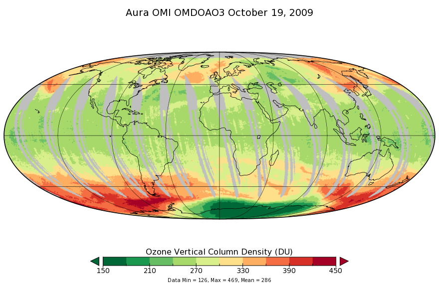
Federal
OMI/Aura Ozone (O3) DOAS Total Column Daily L3 1 day 0.25 degree x 0.25 degree V3 (OMDOAO3e) at GES DISC
National Aeronautics and Space Administration —
The OMI science team produces this Level-3 Aura/OMI Global OMDOAO3e Data Products (0.25deg Lat/Lon grids). This Level-3 global total column ozone product is derived... -
Federal
Comparative Performance of Four Prototype Mechanical Building Cooling Systems in a Desert Climate
Department of Energy —
Data and result of approximately fifteen months of monitoring of four houses located in the desert climate of Borrego Springs, California. Four houses were... -
Federal
CAMEX-4 AEROSONDE V1
National Aeronautics and Space Administration —
The CAMEX-4 Aerosonde dataset contains temperature, humidity, and atmospheric pressure measurements collected to study the boundary layer below levels where... -
Federal
BOREAS TE-05 Leaf Carbon Isotope Data
National Aeronautics and Space Administration —
Contains leaf carbon isotope data collected by TE-05 during 1994. -
Federal
BOREAS RSS-02 Extracted Reflectance Factors Derived from ASAS Imagery
National Aeronautics and Space Administration —
Contains calculated bidirectional reflectance factor means derived from extractions of C130-based ASAS measurements made during BOREAS. -
Federal
BOREAS Landsat TM Level-3s Imagery: Scaled At-Sensor Radiance in LGSOWG Format
National Aeronautics and Space Administration —
For BOREAS, the level-3s Landsat TM data, along with the other remotely sensed images, were collected in order to provide spatially extensive information over the... -
Federal
BOREAS/SRC AMS Suite A Surface Meteorological and Radiation Data: 1996
National Aeronautics and Space Administration —
Contains the data collected in 1996 by the AMS suite A instrument set operated by SRC and provided to BORIS. -
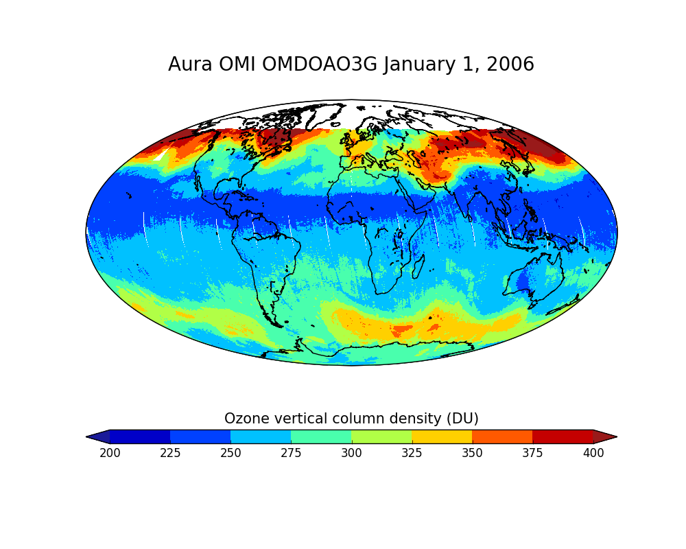
Federal
OMI/Aura Ozone (O3) DOAS Total Column Daily L2 Global Gridded 0.25 degree x 0.25 degree V3 (OMDOAO3G) at GES DISC
National Aeronautics and Space Administration —
This Level-2G daily global gridded product OMDOAO3G is based on the pixel level OMI Level-2 DOAO3 product OMDOAO3. This Level-2G global total column ozone product is...

Official websites use .gov
A
.gov website belongs to an official government
organization in the United States.
Secure .gov websites use HTTPS
A
lock (
) or https:// means you’ve safely connected to
the .gov website. Share sensitive information only on official,
secure websites.