
-
Federal
AirMOSS: L1 S-0 Polarimetric Data from AirMOSS P-band SAR, Chamela, Mexico, 2012-2015
National Aeronautics and Space Administration —
This data set provides level 1 (L1) polarimetric radar backscattering coefficient (sigma-0), multilook complex, polarimetrically calibrated, and georeferenced data... -
Federal
Pre-ABoVE: Gridded Footprints from WRF-STILT Model, Barrow, Alaska, 1982-2011
National Aeronautics and Space Administration —
This dataset provides Stochastic Time-Inverted Lagrangian Transport model outputs for receptors located at the NOAA Barrow Alaska Observatory for 12 selected years... -
Federal
ABoVE: Distribution Maps of Wildland Fire Fuel Components across Alaskan Tundra, 2015
National Aeronautics and Space Administration —
This dataset provides maps of the distribution of three major wildland fire fuel types at 30 m spatial resolution covering the Alaskan arctic tundra, circa 2015. The... -
Federal
CARVE: L1 In-situ Carbon and CH4 Flux and Meteorology at EC Towers, Alaska, 2011-2015
National Aeronautics and Space Administration —
This data set provides ground in situ flux and meteorological science data from fixed instruments at three eddy covariance tower sites located in the Alaskan Arctic... -
Federal
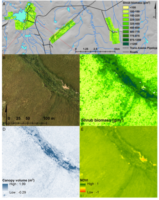
High-Resolution Shrub Biomass and Uncertainty Maps, Toolik Lake Area, Alaska, 2013
National Aeronautics and Space Administration —
This dataset contains estimates for aboveground shrub biomass and uncertainty at high spatial resolution (0.80-m) across three research areas near Toolik Lake,... -
Federal
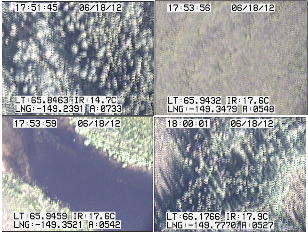
CARVE: In-flight Videos from the CARVE Aircraft, Alaska, 2012-2015
National Aeronautics and Space Administration —
This dataset contains videos captured by a camera mounted on the CARVE aircraft during airborne campaigns over the Alaskan and Canadian Arctic for the Carbon in... -
Federal
Leaf Reflectances: LICOR (OTTER)
National Aeronautics and Space Administration —
The variability of bi-directional spectral reflectance of cut conifer foliage between age classes, species and sites, measured by LICOR -
Federal
ACT-America: CPL-derived Atmospheric Boundary Layer Top Height, Eastern US, 2016-2018
National Aeronautics and Space Administration —
This dataset consists of the atmospheric boundary layer (ABL) top heights and the altitudes of the two additional aerosol layers (in km above mean sea level) derived... -
Federal
CARVE: L2 Atmospheric CO2, CO and CH4 Concentrations, Harvard CRDS, Alaska, 2012-2014
National Aeronautics and Space Administration —
This data set provides atmospheric carbon dioxide (CO2), methane (CH4), and carbon monoxide (CO) concentrations from airborne campaigns over the Alaskan and Canadian... -
Federal
CMS: LiDAR-derived Biomass, Canopy Height and Cover, Sonoma County, California, 2013
National Aeronautics and Space Administration —
This data set provides estimates of above-ground biomass (AGB), canopy height, and percent tree cover at 30-m spatial resolution for Sonoma County, California, USA,... -
Federal
Gross Primary Production Maps of Tidal Wetlands across Conterminous USA, 2000-2019 NGDA
National Aeronautics and Space Administration —
This dataset provides mapped tidal wetland gross primary production (GPP) estimates (g C/m2/day) derived from multiple wetland types at 250-m resolution across the... -
Federal
ABoVE/ASCENDS: Atmospheric Backscattering Coefficient Profiles from CO2 Sounder, 2017
National Aeronautics and Space Administration —
This dataset provides atmospheric backscattering coefficient profiles collected during Active Sensing of CO2 Emissions over Nights, Days, and Seasons (ASCENDS)... -
Federal
AirMOSS: L4 Modeled Volumetric Root Zone Soil Moisture, 2012-2015
National Aeronautics and Space Administration —
This data set provides hourly gridded soil moisture estimates derived from hydrologic modeling at nine AirMOSS sites across North America. The AirMOSS L4 RZSM product... -
Federal
NAFD-ATT Forest Canopy Cover Loss from Landsat, CONUS, 1986-2010
National Aeronautics and Space Administration —
Characterizing the cause of forest canopy changes through time is fundamental to understanding current and future forest functions. A better understanding of forest... -
Federal
CMS: Mangrove Canopy Height Estimates from Remote Imagery, Zambezi Delta, Mozambique
National Aeronautics and Space Administration —
This data set provides high resolution canopy height estimates for mangrove forests in the Zambezi Delta, Mozambique, Africa. The estimates were derived from three... -
Federal
Delta-X: AirSWOT L2 Geocoded Water Surface Elevation, MRD, Louisiana, 2021, Version 2
National Aeronautics and Space Administration —
This dataset contains Level 2 (L2) AirSWOT geocoded products, including estimated water surface elevation. The AirSWOT instrument is a Ka-band interferometer and for... -
Federal
CMS: Modeled Net Ecosystem Exchange at 3-hourly Time Steps, 2004-2010
National Aeronautics and Space Administration —
This data set provides global, gridded, model-derived net ecosystem exchange (NEE) of CO2 flux between the land and atmosphere at 3-hourly time steps over seven years... -
Federal
ABoVE: Needle-Level Chlorophyll Fluorescence, Alaska and Idaho, USA, 2017 and 2019
National Aeronautics and Space Administration —
This dataset provides the results of in situ measurements of needle-level chlorophyll fluorescence (ChlF) obtained from a pulse amplitude modulated (PAM) fluorometer... -
Federal
Pre-Delta-X: AVIRIS-derived Total Suspended Solids Maps for MRD, LA, USA, 2015-2016
National Aeronautics and Space Administration —
This dataset includes total suspended solids (TSS) at the water surface across the Atchafalaya and Terrebonne Basins in Southern Louisiana, USA, within the... -
Federal
Arctic Vegetation Plots for IBP Tundra Biome, Barrow, Alaska, 1972-2010
National Aeronautics and Space Administration —
This data set provides vegetation cover and environmental plot data collected as part of the International Biological Program (IBP), U. S. Tundra Biome Program, in...

Official websites use .gov
A
.gov website belongs to an official government
organization in the United States.
Secure .gov websites use HTTPS
A
lock (
) or https:// means you’ve safely connected to
the .gov website. Share sensitive information only on official,
secure websites.