
-
Federal
U.S. Billion-dollar Weather and Climate Disasters, 1980 - present (NCEI Accession 0209268)
National Oceanic and Atmospheric Administration, Department of Commerce —
The NOAA National Centers for Environmental Information ceased providing support for this product in May 2025 in response to an initiative to implement reductions... -
County
Allegheny County 911 Dispatches - EMS and Fire
Allegheny County / City of Pittsburgh / Western PA Regional Data Center —
The Allegheny County 911 center answers and dispatches 911 calls for 111 out of 130 municipalities in Allegheny County. Agencies are dispatched via a computer aided... -
Federal
GEDI L2B Canopy Cover and Vertical Profile Metrics Data Global Footprint Level V002
National Aeronautics and Space Administration —
The Global Ecosystem Dynamics Investigation (GEDI) mission aims to characterize ecosystem structure and dynamics to enable radically improved quantification and... -
Federal
Aviation Safety Reporting System: Cabin Smoke, Fire, Fumes, or Odor Incidents
National Aeronautics and Space Administration —
A sampling of air carrier reports concerning cabin smoke, fire, fumes or odor related events. -
Federal
VIIRS/NPP Thermal Anomalies/Fire 6-Min L2 Swath 750m V002
National Aeronautics and Space Administration —
The Visible Infrared Imaging Radiometer Suite (VIIRS) Thermal Anomalies (VNP14) Version 2 product is produced in 6-minute temporal satellite increments (swaths) at... -
State
Drinking Water - Public Water System Annually Reported Number of Service Connections Metered and Unmetered by Service Connection Type
State of California —
This dataset includes the number of service connections, categorized by type and metering status, as submitted by public water systems via the electronic annual... -
Federal
Alpha Jet Atmospheric eXperiment Ozone Data
National Aeronautics and Space Administration —
The Alpha Jet Atmospheric eXperiment (AJAX) is a partnership between NASA's Ames Research Center and H211, L.L.C., facilitating routine in-situ measurements over... -
Federal
Critical Facilities for Coastal Geographies
National Oceanic and Atmospheric Administration, Department of Commerce —
The critical facilities data are derived from the USGS Structures Inventory Database (June, 2016). The structures in the derived dataset displays aggregated totals of... -
Federal
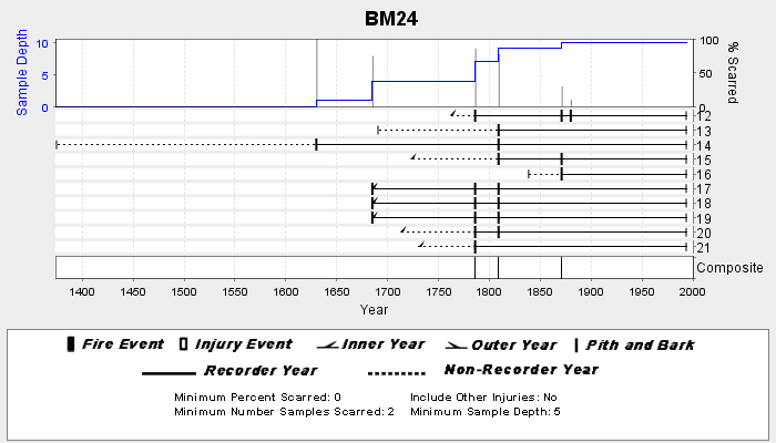
NOAA/WDS Paleoclimatology - Veblen fire data from BM24 - IMPD USBM-024
National Oceanic and Atmospheric Administration, Department of Commerce —
This archived Paleoclimatology Study is available from the NOAA National Centers for Environmental Information (NCEI), under the World Data Service (WDS) for... -
Federal
NACP Integrated Wildland and Cropland 30-m Fuel Characteristics Map, U.S.A., 2010
National Aeronautics and Space Administration —
The data set provides a 30-m comprehensive fuelbed characteristics map for both the wildland and cropland areas of the conterminous United States (CONUS) for 2010.... -
Federal
Global Fire Atlas with Characteristics of Individual Fires, 2003-2016
National Aeronautics and Space Administration —
The Global Fire Atlas is a global dataset that tracks the day-to-day dynamics of individual fires to determine the timing and location of ignitions, fire size,... -
Federal
Danger Zones and Restricted Areas
National Oceanic and Atmospheric Administration, Department of Commerce —
These data represent the location of Danger Zones and Restricted Areas within coastal and marine waters, as outlined by the Code of Federal Regulations (CFR) and the... -
Federal
ABoVE: Thaw Depth at Selected Unburned and Burned Sites Across Alaska
National Aeronautics and Space Administration —
This dataset provides thaw depth measurements made at seven locations across Alaska, during August 2016, June and September 2017, and July-August 2018. Three of the... -
Federal
Technical Report-Rare Earth Element Concentrations in Wyoming's Produced Waters
Department of Energy —
This study is a joint effort by the University of Wyoming (UW), the UW Engineering Department (UW-ENG), and Idaho National Laboratories (INL) and the United States... -
Federal
Alpha Jet Atmopsheric eXperiment Meteorological Measurement System (MMS) Data
National Aeronautics and Space Administration —
The Alpha Jet Atmospheric eXperiment (AJAX) is a partnership between NASA's Ames Research Center and H211, L.L.C., facilitating routine in-situ measurements over... -
Federal
First ISCCP Regional Experiment (FIRE) Cirrus 2 Volume Imaging Lidar (VIL) Altitude vs. Time (RTI) Data
National Aeronautics and Space Administration —
The First ISCCP Regional Experiments have been designed to improve data products and cloud/radiation parameterizations used in general circulation models (GCMs).... -
Federal
Database Masterfile
U.S. Environmental Protection Agency —
The dataset is a emission factor database for open burning, open detonation and static fire of obsolete military ordnance. -
Federal
Land Use and Cover Maps from Landsat, Mawas, Central Kalimantan, Indonesia, 1994-2019
National Aeronautics and Space Administration —
This dataset contains annual land use/cover (LUC) maps at 30 m resolution across Mawas, Central Kalimantan, Indonesia. There are six files, each representing a five-... -
Federal
MODIS/Terra+Aqua Direct Broadcast Burned Area Monthly L3 Global 500m SIN Grid V006
National Aeronautics and Space Administration —
The MCD64A1 Version 6 data product was decommissioned on July 31, 2023. Users are encouraged to use the MCD64A1 Version 6.1 data product.The Terra and Aqua combined... -
Federal
First ISCCP Regional Experiment (FIRE) Atlantic Stratocumulus Transition Experiment (ASTEX) NASA ER-2 Cloud Lidar System Data
National Aeronautics and Space Administration —
The First ISCCP Regional Experiments have been designed to improve data products and cloud/radiation parameterizations used in general circulation models (GCMs)....

Official websites use .gov
A
.gov website belongs to an official government
organization in the United States.
Secure .gov websites use HTTPS
A
lock (
) or https:// means you’ve safely connected to
the .gov website. Share sensitive information only on official,
secure websites.