
-
Federal
NACP North American Forest Dynamics Project: Forest Disturbance and Regrowth Data
National Aeronautics and Space Administration —
This data set provides the results of time-series analyses of Landsat imagery for 55 selected forested sites across the conterminous U.S.A. The output is a pair of... -
Federal
Glacier Photograph Collection, Version 1
National Aeronautics and Space Administration —
Notice: Due to funding limitations, this data set was recently changed to a “Basic” Level of Service. Learn more about what this means for users and how you can share... -
Federal
Satellite Observations of Arctic Change, Version 1
National Aeronautics and Space Administration —
The purpose of this site is to expose NASA satellite data and research on Arctic change in the form of maps that illustrate the changes taking place in the Arctic... -
Federal
Nenana Ice Classic: Tanana River Ice Annual Breakup Dates, Version 2
National Aeronautics and Space Administration —
The Tanana river in the Interior of Alaska usually freezes over during October and November. The ice continues to grow throughout the winter accumulating an average... -
Federal
A Global Database of Gas Fluxes from Soils after Rewetting or Thawing, Version 1.0
National Aeronautics and Space Administration —
This database contains information compiled from published studies on gas flux from soil following rewetting or thawing. The resulting database includes 222 field and... -
Federal
Sea Ice Index, Version 4
National Aeronautics and Space Administration —
Notice: Due to funding limitations, this data set was recently changed to a “Basic” Level of Service. Learn more about what this means for users and how you can share... -
Federal
ISLSCP II EDGAR 3 Gridded Greenhouse and Ozone Precursor Gas Emissions
National Aeronautics and Space Administration —
The EDGAR (Emission Database for Global Atmospheric Research) database project is a comprehensive task carried out jointly by the National Institute for Public Health... -
Federal
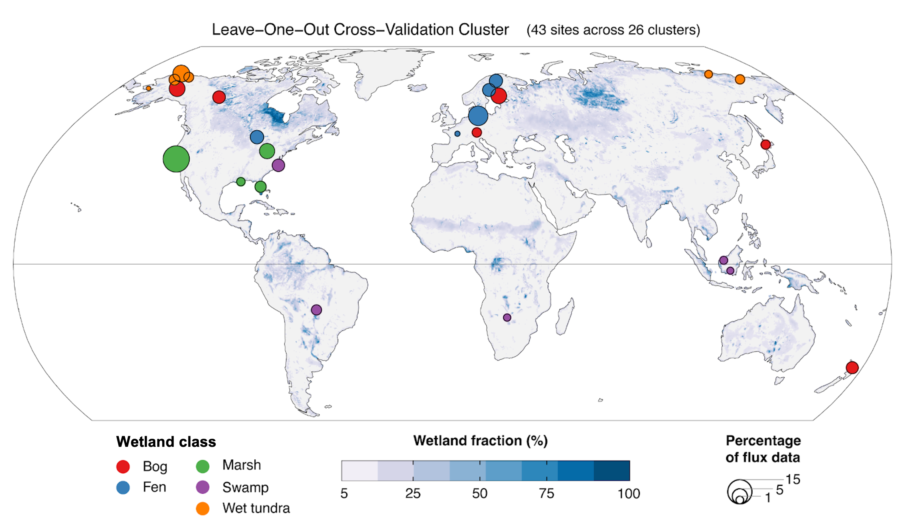
NACP Site: Terrestrial Biosphere Model and Aggregated Flux Data in Standard Format
National Aeronautics and Space Administration —
This data set provides standardized output variables for gross primary productivity (GPP), net ecosystem exchange (NEE), leaf area index (LAI), ecosystem respiration... -
Federal
GHRSST Level 3U Global Subskin Sea Surface Temperature version 8a from the Advanced Microwave Scanning Radiometer 2 on the GCOM-W satellite
National Aeronautics and Space Administration —
GDS2 Version -The Advanced Microwave Scanning Radiometer 2 (AMSR2) was launched on 18 May 2012, onboard the Golbal Change Observation Mission - Water (GCOM-W)... -
Federal
ECCO Ocean Three-Dimensional Volume Fluxes - Monthly Mean llc90 Grid (Version 4 Release 4)
National Aeronautics and Space Administration —
This dataset provides monthly-averaged ocean three-dimensional volume fluxes on the native Lat-Lon-Cap 90 (LLC90) model grid from the ECCO Version 4 Release 4 (V4r4)... -
Federal
HAQAST Sentinel-5P TROPOMI Nitrogen Dioxide (NO2) GLOBAL Annual Level 3 0.1 x 0.1 Degree Gridded Data Version 2.4 (HAQ_TROPOMI_NO2_GLOBAL_A_L3) at GES DISC
National Aeronautics and Space Administration —
This product provides level 3 annual averages of tropospheric Nitrogen dioxide (NO2) vertical column density derived from the level 2 Tropospheric Monitoring... -
Federal
Greenland Ice Sheet Melt Characteristics Derived from Passive Microwave Data, Version 1
National Aeronautics and Space Administration —
The Greenland ice sheet melt extent data, acquired as part of the NASA Program for Arctic Regional Climate Assessment (PARCA), is a daily (or every other day, prior... -
Federal
Daymet: Daily Surface Weather Data on a 1-km Grid for North America, Version 4 R1
National Aeronautics and Space Administration —
This dataset provides Daymet Version 4 R1 data as gridded estimates of daily weather parameters for North America, Hawaii, and Puerto Rico. Daymet variables include... -
Federal
GRACE OCEAN BOTTOM GEOPOTENTIAL COEFFICIENTS GFZ RELEASE 6.0 GAD
National Aeronautics and Space Administration —
FOR EXPERT USE ONLY. This dataset contains estimates of ocean bottom pressure derived from the Gravity Recovery and Climate Experiment (GRACE) mission measurements,... -
Federal
Sea Ice Trends and Climatologies from SMMR and SSM/I-SSMIS, Version 3
National Aeronautics and Space Administration —
NSIDC provides this data set to aid investigations of variability and trends in sea ice cover. Ice cover in these data are indicated by sea ice concentration: the... -
Federal
VIIRS/NPP BRDF/Albedo Parameter 1 Band M7 Daily L3 Global 30 ArcSec CMG V001
National Aeronautics and Space Administration —
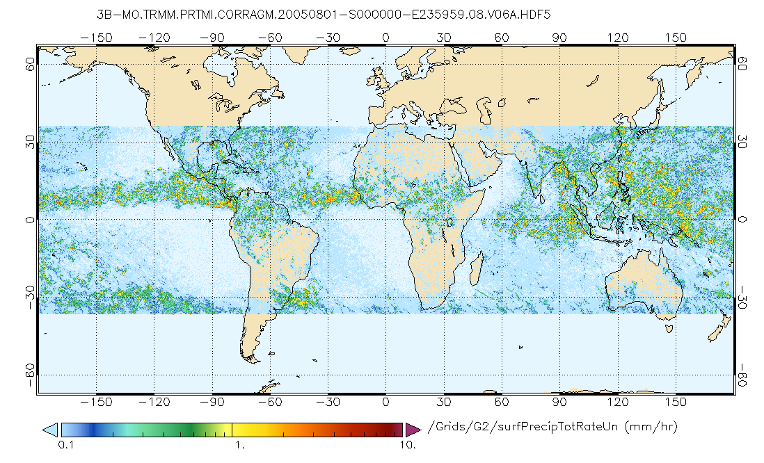
The VNP43D16 Version 1 data product was decommissioned on July 31, 2025. Users are encouraged to use theFederalGPM PR and TMI on TRMM (Combined Precipitation) L3 1 month 0.25x0.25 degree V07 (GPM_3CMB_TRMM) at GES DISC
National Aeronautics and Space Administration —
This is the new (GPM-formated) TRMM Combined product, using the GPM algorithms, for the TRMM epoch (December 1997 - April 2015). It replaces the old TRMM_3B31 This is...FederalMODIS/Terra+Aqua BRDF/Albedo Parameter1 Band2 Daily L3 Global 30ArcSec CMG V006
National Aeronautics and Space Administration —
The MCD43D04 Version 6 data product was decommissioned on July 31, 2023. Users are encouraged to use the MCD43D04...FederalECCO Global Mean Atmospheric Pressure - Snapshot (Version 4 Release 4)
National Aeronautics and Space Administration —
This dataset provides instantaneous hourly global mean atmospheric pressure from the ECCO Version 4 Release 4 (V4r4) ocean and sea-ice state estimate. Estimating the...FederalGlobal Organic Soil Carbon and Nitrogen (Zinke et al.)
National Aeronautics and Space Administration —
This package contains worldwide soil carbon and nitrogen data for more than 3,500 soil profiles. The database was begun about 40 years ago with the collection and...1,686 datasets found for "climate"

Official websites use .gov
A
.gov website belongs to an official government
organization in the United States.
Secure .gov websites use HTTPS
A
lock (
) or https:// means you’ve safely connected to
the .gov website. Share sensitive information only on official,
secure websites.