
-
Federal
TCTE Level 3 Total Solar Irradiance 6-Hour Means V004 (TCTE3TSI6) at GES DISC
National Aeronautics and Space Administration —
TCTE3TSI6 Version 004 is the final version of this data product, and supersedes all previous versions. The Total Solar Irradiance (TSI) Calibration Transfer... -
Federal
TROPESS CrIS-SNPP L2 for Delhi Megacity, Summary Product V1 (TRPSYL2ALLCRSMGDEL) at GES DISC
National Aeronautics and Space Administration —
The TROPESS CrIS-SNPP L2 for Delhi Megacity, Summary Product contains the vertical distribution of six retrieved atmospheric gases (CH4, CO, HDO, NH3, O3 and PAN),... -
Federal
Jaeger Monthly Mean Global Precipitation Climatology 2.5 x 5.0 degree V1 (RAIN_JEAGER) at GES DISC
National Aeronautics and Space Administration —
The Jaeger Surface Rain Gauge Observations data set consists of gridded mean monthly global precipitation values for 1931 to 1960 over the continents and 1955 to 1965... -
Federal
GVHRR/ATS-6 Black and White Visible Images on Film V001 (GVHRRATS6IMVIS) at GES DISC
National Aeronautics and Space Administration —
GVHRRATS6IMVIS is the Geosynchronous Very High Resolution Radiometer (GVHRR) Black and White Visible Images on Film data product from the sixth Applications... -
Federal
Autonomous Parsivel Unit (APU) IMPACTS
National Aeronautics and Space Administration —
The Autonomous Parsivel Unit (APU) IMPACTS data were collected in support of the Investigation of Microphysics and Precipitation for Atlantic Coast-Threatening... -
Federal
MODIS/Terra Land Surface Temperature/Emissivity 8-Day L3 Global 6km SIN Grid V061
National Aeronautics and Space Administration —
The Terra Moderate Resolution Imaging Spectroradiometer (MODIS) Land Surface Temperature/Emissivity 8-Day (MOD11B2) Version 6.1 product provides an average 8-day per... -
Federal
NASA 3D Models: TDRS
National Aeronautics and Space Administration —
Polygons: 2808 Vertices: 1977 -
Federal
SMAP Level 1C High Resolution Radar Sigma Naught Swath Grid Product (Version 2)
National Aeronautics and Space Administration —
SMAP Level 1C Sigma Naught High Res Product Version 2 -
Federal
VIIRS/JPSS1 BRDF/Albedo Model Parameters Daily L3 Global 500 m SIN Grid NRT
National Aeronautics and Space Administration —
The VIIRS/JPSS1 BRDF/Albedo Model Parameters Daily L3 Global 500 m SIN Grid Near Real Time (NRT), short-name VJ143IA1N product provides BRDF/Albedo model parameters... -
Federal
Rapid X-band Polarimetric Radar (RaXPol) IMPACTS
National Aeronautics and Space Administration —
The Rapid X-band Polarimetric Radar (RaXPol) IMPACTS dataset consists of data measured from the RaXPol instrument during the Investigation of Microphysics and... -
Federal
Explorer-7 Thermal Radiation Experiment Temperature Values from All Sensors V001 (EXP7L1TRTALL) at GES DISC
National Aeronautics and Space Administration —
Explorer-7 Thermal Radiation Experiment Temperature Values from All Sensors product contains temperature readings from all five bolometers in order to measure solar,... -
Federal
CAMP2Ex Cloud and Precipitation Retrievals Derived From APR-3 and AMPR Measurements
National Aeronautics and Space Administration —
CAMP2Ex-Cloud-Precip-Retrieval_1 are cloud and precipitation retrievals derived from the Advanced Precipitation Radar 3 (APR-3) and Advanced Microwave Precipitation... -
Federal
MODIS/Terra+Aqua Land Aerosol Optical Depth Daily L2G Global 1km SIN Grid V061
National Aeronautics and Space Administration —
The MCD19A2 Version 6.1 data product is a Moderate Resolution Imaging Spectroradiometer (MODIS) Terra and Aqua combined Multi-angle Implementation of Atmospheric... -
Federal
Spitzer Extragalactic Representative Volume Survey Lockman Hole 3.6 micron Catalog
National Aeronautics and Space Administration —
The "Spitzer Extragalactic Representative Volume Survey" (SERVS) Exploration Science program conducted deep IRAC 3.6 and 4.5 micron observations of five extragalactic... -
Federal
NGC 2024 Chandra X-Ray Point Source Catalog
National Aeronautics and Space Administration —
The NGC 2024 Chandra X-Ray Point Source Catalog contains the results of a sensitive 76 ks Chandra observation of the young stellar cluster in NGC 2024, lying at a... -
Federal
Lyford (LYFD) Ground-based Vector Magnetic Field (L2) 0.5 s Data
National Aeronautics and Space Administration —
Lyford, TX, Ground-based Vector Magnetic Field Level 2 Data, 0.5 s Time Resolution, Station Code: (LYFD), Station Location: (GEO Latitude 26.4, Longitude 262.2),... -
Federal
MODIS Aqua Level 3 SST MID-IR 8 Day 4km Nighttime V2019.0
National Aeronautics and Space Administration —
Day and night spatially gridded (L3) global NASA skin sea surface temperature (SST) products from the Moderate-resolution Imaging Spectroradiometer (MODIS) onboard... -
Federal
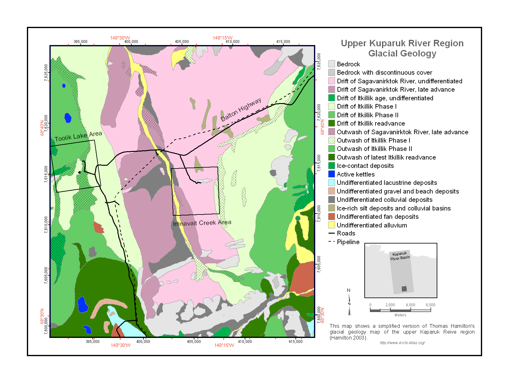
Maps of Vegetation Types and Physiographic Features, Kuparuk River Basin, Alaska
National Aeronautics and Space Administration —
This data set provides a collection of vegetation, landscape, geobotanical, elevation, hydrology, and geologic maps for the Kuparuk River Basin, North Slope, Alaska.... -
Federal
Sentinel-6A MF Jason-CS L3 P4 Altimeter Low Resolution (LR) NTC Ocean Surface Topography (Unfiltered) Version F08
National Aeronautics and Space Administration —
Provides L3 low resolution (LR) non-time critical (NTC; 60-day latency) altimetry from the Poseidon-4 SAR altimeter on the Sentinel-6A Michael Freilich spacecraft,...

Official websites use .gov
A
.gov website belongs to an official government
organization in the United States.
Secure .gov websites use HTTPS
A
lock (
) or https:// means you’ve safely connected to
the .gov website. Share sensitive information only on official,
secure websites.