
-
Federal
NACP North American Forest Dynamics Project: Forest Disturbance and Regrowth Data
National Aeronautics and Space Administration —
This data set provides the results of time-series analyses of Landsat imagery for 55 selected forested sites across the conterminous U.S.A. The output is a pair of... -
Federal
Snake River Plain FORGE: Site Characterization Data
Department of Energy —
The site characterization data used to develop the conceptual geologic model for the Snake River Plain site in Idaho, as part of phase 1 of the Frontier Observatory... -
Federal
Global Data Set of Derived Soil Properties, 0.5-Degree Grid (ISRIC-WISE)
National Aeronautics and Space Administration —
The World Inventory of Soil Emission Potentials (WISE) database currently contains data for over 4300 soil profiles collected mostly between 1950 and 1995. This... -
Federal
Eddy Corr. Surface Flux: USGS (FIFE)
National Aeronautics and Space Administration —
Surface flux measurements were made at selected sites within the FIFE area. Each surface flux station was capable of measuring the fluxes of net radiation, sensible... -
Federal
ECOSTRESS Gridded Downscaled Meteorology Instantaneous L3 Global 70 m V002
National Aeronautics and Space Administration —
The ECOsystem Spaceborne Thermal Radiometer Experiment on Space Station (ECOSTRESS) mission measures the temperature of plants to better understand how much water... -
Federal
USU Camas-1 Test Well: Documentation
Department of Energy —
This submission contains documents that describe the USU Camas-1 test well, drilled in Camas Prairie, Idaho, in Fall 2018 and Fall 2019. The purpose of this well is... -
Federal
CERES Single Scanner Footprint (SSF) TOA/Surface Fluxes, Clouds and Aerosols Terra-FM1 Edition4A
National Aeronautics and Space Administration —
CER_SSF_Terra-FM1-MODIS_Edition4A is the Clouds and the Earth's Radiant Energy System (CERES) Single Scanner Footprint (SSF) Top-of-the-Atmosphere (TOA)/Surface... -
Federal
Daymet: Daily Surface Weather Data on a 1-km Grid for North America, Version 4 R1
National Aeronautics and Space Administration —
This dataset provides Daymet Version 4 R1 data as gridded estimates of daily weather parameters for North America, Hawaii, and Puerto Rico. Daymet variables include... -
Federal
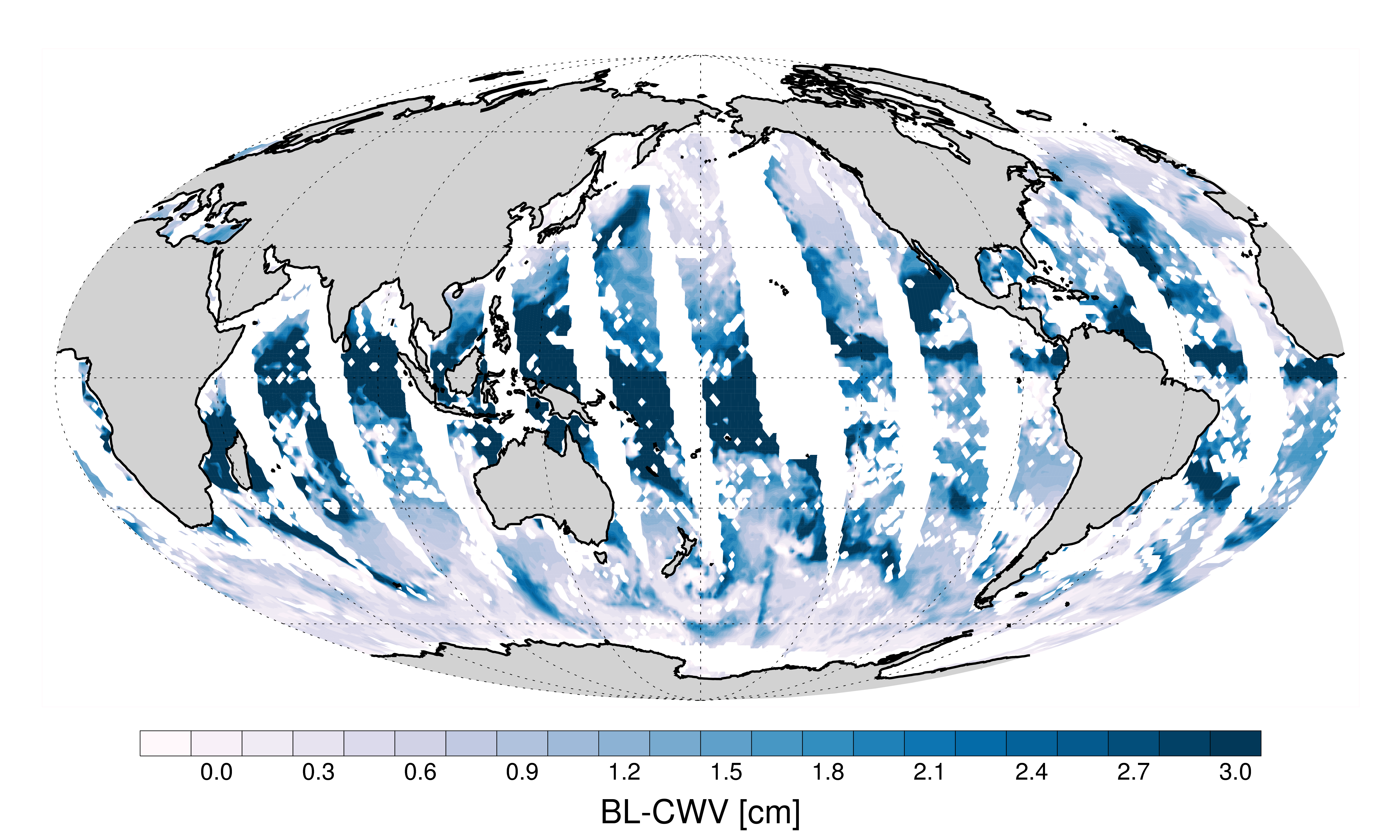
AMSR-MODIS Boundary Layer Water Vapor L3 Daily 1 degree x 1 degree V1 (AMDBLWV) at GES DISC
National Aeronautics and Space Administration —
This data set provides an estimate the marine boundary layer water vapor beneath uniform cloud fields. Microwave radiometry from AMSR-E and AMSR-2 provides the total... -
Federal
GEDI L2A Elevation and Height Metrics Data Global Footprint Level V002
National Aeronautics and Space Administration —
The Global Ecosystem Dynamics Investigation (GEDI) mission aims to characterize ecosystem structure and dynamics to enable radically improved quantification and... -
Federal
TROPESS CrIS-SNPP L2 Deuterated Water Vapor for Reanalysis Stream, Summary Product V1 (TRPSYL2HDOCRSRS) at GES DISC
National Aeronautics and Space Administration —
The TROPESS CrIS-SNPP L2 Deuterated Water Vapor for Reanalysis Stream, Summary Product contains the vertical distribution of the retrieved atmospheric state of semi-... -
Federal
Bowen Ratio Surface Flux: KSU (FIFE)
National Aeronautics and Space Administration —
The Bowen Ratio Surface Flux Observations (KSU) Data Set contains surface flux measurements made at selected sites within the FIFE area. The sites were equipped with... -
Federal
Sounder SIPS: JPSS-1 ATMS Level 3 RAMSES2 Standard Gridded Monthly V3 at GES DISC
National Aeronautics and Space Administration —
This level 3 monthly product is generated from the RAMSES (Retrieval Algorithm for Microwave Sounders in Earth Science) II algorithm.The RAMSES II algorithm is a... -
Federal
GPM MHS on NOAA-18 (GPROF) Radiometer Precipitation Profiling L2A 1.5 hours 17 km V07 (GPM_2AGPROFNOAA18MHS_CLIM) at GES DISC
National Aeronautics and Space Administration —
Version 07 is the current version of the data set. Older versions are no longer available and have been superseded by Version 07.The "CLIM" products differ from their... -
Federal
Global Hydrologic Soil Groups (HYSOGs250m) for Curve Number-Based Runoff Modeling
National Aeronautics and Space Administration —
This dataset - HYSOGs250m - represents a globally consistent, gridded dataset of hydrologic soil groups (HSGs) with a geographical resolution of 1/480 decimal... -
Federal
CERES and GEO-Enhanced TOA, Within-Atmosphere, and Surface Fluxes Clouds and Aerosols Monthly Terra Edition4A
National Aeronautics and Space Administration —
CER_SYN1deg-Month_Terra-MODIS_Edition4A is the Clouds and the Earth's Radiant Energy System (CERES) and and geostationary (GEO)-Enhanced Top of Atmosphere (TOA),... -
Federal
GPM SSMIS on F16 (GPROF) Climate-based Radiometer Precipitation Profiling L3 1 month 0.25 degree x 0.25 degree V07 (GPM_3GPROFF16SSMIS_CLIM) at GES DISC
National Aeronautics and Space Administration —
Version 07 is the current version of the data set. Older versions will no longer be available and have been superseded by Version 07. The "CLIM" products differ from... -
Federal
IRIS/Nimbus-4 Level 1 Radiance Data V001 (IRISN4RAD) at GES DISC
National Aeronautics and Space Administration —
The Nimbus-4 Infrared Interferometer Spectrometer (IRIS) Level 1 Radiance Data contain thermal emissions of the Earth's atmosphere at wave numbers between 400 and...

Official websites use .gov
A
.gov website belongs to an official government
organization in the United States.
Secure .gov websites use HTTPS
A
lock (
) or https:// means you’ve safely connected to
the .gov website. Share sensitive information only on official,
secure websites.