
-
City
Land Cover Raster Data (2017) – 6in Resolution
City of New York —
A 6-in resolution 8-class land cover dataset derived from the 2017 Light Detection and Ranging (LiDAR) data capture. This dataset was developed as part of an updated... -
Federal
ARPA-E Grid Optimization (GO) Competition Challenge 3
Department of Energy —
Synthetic Input Data and Team Results for the GO Competition Challenge 3 for Events 1 - 4 and the Sandbox, along with problem and format descriptions and code to... -
Federal
2024 County-Level Hourly Renewable Capacity Factor Dataset for the ReEDS Model
Department of Energy —
This dataset contains hourly capacity factors for each renewable resource class and region (in this case, county). Technologies like large-scale utility PV (UPV),... -
Federal
Reference Model 3 Scaled Geometry (RM3: Wave Point Absorber)
Department of Energy —
Contains the Reference Model 3 (RM3) scaled scale geometry files of the Wave Point Absorber, developed by the Reference Model Project (RMP). These scaled geometry... -
Federal
NUOnet (Nutrient Use and Outcome Network) database
Department of Agriculture —
NUOnet Vision: Efficient use of nutrients to optimize production and product quality of food for animals and humans, fuel and fiber in a sustainable manner that... -
Federal
Utility-Scale Solar, 2024 Edition: Analysis of Empirical Plant-level Data from U.S. Ground-mounted PV, PV+battery, and CSP Plants (exceeding 5 MWAC)
Department of Energy —
Berkeley Labs "Utility-Scale Solar", 2024 Edition presents analysis of empirical plant-level data from the U.S. fleet of ground-mounted photovoltaic (PV), PV+battery,... -
Federal
Utility-Scale Solar, 2023 Edition: Analysis of Empirical Plant-level Data from U.S. Ground-mounted PV, PV+battery, and CSP Plants (exceeding 5 MWAC)
Department of Energy —
Berkeley Labs "Utility-Scale Solar", 2023 Edition presents analysis of empirical plant-level data from the U.S. fleet of ground-mounted photovoltaic (PV), PV+battery,... -
State
DWR Airborne Electromagnetic (AEM) Surveys Data
State of California —
Statewide AEM Surveys Project Overview The Department of Water Resources’ (DWR’s) Statewide Airborne Electromagnetic (AEM) Surveys Project is funded through... -
University
GNIS: Buildings (2013)
Earth Data Analysis Center, University of New Mexico —
The Geographic Names Information System (GNIS) is the Federal standard for geographic nomenclature. The U.S. Geological Survey developed the GNIS for the U.S. Board... -
Federal
Habitat surface - A landscape connectivity analysis for the coastal marten (Martes caurina humboldtensis)
Department of the Interior —
This dataset serves as the habitat surface that was used to derive coastal marten habitat cores for use in our connectivity model. Of note, the set of habitat cores... -
Federal
EnviroAtlas - Water Balance and Surficial Groundwater by 12-digit HUC for the Conterminous United States
U.S. Environmental Protection Agency —
This EnviroAtlas dataset summarizes several U.S. Geological Survey (USGS) water budget and surficial groundwater datasets by 12-digit HUC. It includes average rates... -
Federal
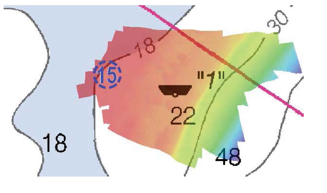
H11862: NOS Hydrographic Survey , Charleston Harbor, South Carolina, 2009-04-23
National Oceanic and Atmospheric Administration, Department of Commerce —
The National Oceanic and Atmospheric Administration (NOAA) has the statutory mandate to collect hydrographic data in support of nautical chart compilation for safe... -
Federal
D00199: NOS Hydrographic Survey , 2015-06-16
National Oceanic and Atmospheric Administration, Department of Commerce —
The National Oceanic and Atmospheric Administration (NOAA) has the statutory mandate to collect hydrographic data in support of nautical chart compilation for safe... -
Federal
H12996: NOS Hydrographic Survey , 2017-07-02
National Oceanic and Atmospheric Administration, Department of Commerce —
The National Oceanic and Atmospheric Administration (NOAA) has the statutory mandate to collect hydrographic data in support of nautical chart compilation for safe... -
Federal
2018 - 2020 NOAA USGS Lidar: Hawaii, HI
National Oceanic and Atmospheric Administration, Department of Commerce —
Product: Processed, classified lidar point cloud data tiles in LAS 1.4 format. Geographic Extent: Approximately 4,028 square miles encompassing the Big Island of... -
Federal
Willapa Bay, Washington Benthic Habitats 1995 Substrate
National Oceanic and Atmospheric Administration, Department of Commerce —
In June 1995, the Columbia River Estuary Study Taskforce (CREST) acquired 295 true color aerial photographs (1:12,000) of Willapa Bay, Washington, from the State of... -
City
Louisville Metro KY - Jefferson County Demolitions, Demolished from FY2003 to FY2020
Louisville Metro Government —
Develop Louisville Focuses on the full range of land development activities, including planning and design, vacant property initiatives, advanced planning, housing... -
Federal
H12110: NOS Hydrographic Survey , San Fransisco Bay, California, 2009-08-03
National Oceanic and Atmospheric Administration, Department of Commerce —
The National Oceanic and Atmospheric Administration (NOAA) has the statutory mandate to collect hydrographic data in support of nautical chart compilation for safe... -
Federal
Viewsheds from Key Observation Points for Fort Union Trading Post National Historic Site (FOUS)
Department of the Interior —
Visibility viewsheds incorporate influences of distance from observer, object size and limits of human visual acuity to define the degree of visibility as a... -
Federal
EnviroAtlas - Atmospheric Nitrogen and Sulfur Deposition by 12-digit HUC for the Conterminous United States (2017)
U.S. Environmental Protection Agency —
This EnviroAtlas dataset includes annual nitrogen and sulfur deposition within each 12-digit HUC subwatershed for the year 2017. Values are provided for total...

Official websites use .gov
A
.gov website belongs to an official government
organization in the United States.
Secure .gov websites use HTTPS
A
lock (
) or https:// means you’ve safely connected to
the .gov website. Share sensitive information only on official,
secure websites.
.jpg)