
-
Federal
Last of the Wild Project, Version 2, 2005 (LWP-2): Global Human Footprint Dataset (Geographic)
National Aeronautics and Space Administration —
The Global Human Footprint Dataset of the Last of the Wild Project, Version 2, 2005 (LWP-2) is the Human Influence Index (HII) normalized by biome and realm. The HII... -
Federal
Last of the Wild Project, Version 2, 2005 (LWP-2): Global Human Influence Index (HII) Dataset (Geographic)
National Aeronautics and Space Administration —
The Global Human Influence Index Dataset of the Last of the Wild Project, Version 2, 2005 (LWP-2) is a global dataset of 1-kilometer grid cells, created from nine... -
Federal
Last of the Wild Project, Version 3 (LWP-3): 2009 Human Footprint, 2018 Release
National Aeronautics and Space Administration —
The 2009 Human Footprint, 2018 Release provides a global map of the cumulative human pressure on the environment in 2009, at a spatial resolution of ~1 km. The human... -
Federal
Coral Reef Resilience and Social Vulnerability to Climate Change in the U.S.-affiliated Pacific Islands
National Oceanic and Atmospheric Administration, Department of Commerce —
This dataset results from an analysis of exposure, resilience, and social vulnerability to climate change threats for the coral reefs of the U.S.-affiliated Pacific... -
Federal
CRED Towed-Diver Fish Biomass Surveys at Alamagan Island, Marianas Archipelago in 2005
National Oceanic and Atmospheric Administration, Department of Commerce —
Towed-diver surveys (aka. Towboard surveys) are conducted by the Coral Reef Ecosystem Division (CRED) of the NOAA Pacific Islands Fisheries Science Center (PIFSC) as... -
Federal
Cetacean visual observations using line-transect survey methods onboard the NOAA Ship PISCES in the Gulf of Mexico from 2018-08-12 to 2018-10-05 (NCEI Accession 0244002)
National Oceanic and Atmospheric Administration, Department of Commerce —
As part of the Gulf of Mexico Marine Assessment Program for Protected Species (GoMMAPPS), the Southeast Fisheries Science Center (SEFSC) conducted shipboard surveys... -
Federal
Cetacean and sea turtle visual observations using line-transect survey methods aboard a NOAA DeHavilland DHC-6 Twin Otter (TO) aircraft in the Gulf of Mexico, during the Gulf of Mexico Marine Assessment Program for Protected Species (GoMMAPPS survey TO18Fa) from 10/12/2018 to 11/28/2018.
National Oceanic and Atmospheric Administration, Department of Commerce —
As part of the Gulf of Mexico Marine Assessment Program for Protected Species (GoMMAPPS), the Southeast Fisheries Science Center (SEFSC) conducted aerial surveys of... -
Federal
NCCOS Sponsored Research Project: Understanding Coral Ecosystem Connectivity in the Gulf of Mexico from Pulley Ridge to the Florida Keys
National Oceanic and Atmospheric Administration, Department of Commerce —
This project investigated the role that the mesophotic coral ecosystems (~60â100 m) of Pulley Ridge (off the southwest coast of Florida) play in replenishing key... -
Federal
CRED Towed-Diver Fish Biomass Surveys at Pearl And Hermes Atoll, NW Hawaiian Islands in 2003
National Oceanic and Atmospheric Administration, Department of Commerce —
Towed-diver surveys (aka. Towboard surveys) are conducted by the Coral Reef Ecosystem Division (CRED) of the NOAA Pacific Islands Fisheries Science Center (PIFSC) as... -
Federal
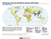
Anthropogenic Biomes of the World, Version 2: 2000
National Aeronautics and Space Administration —
The Anthropogenic Biomes of the World, Version 2: 2000 data set describes anthropogenic transformations within the terrestrial biosphere caused by sustained direct... -
Federal
Last of the Wild Project, Version 1, 2002 (LWP-1): Global Human Footprint Dataset (Geographic)
National Aeronautics and Space Administration —
The Global Human Footprint Dataset of the Last of the Wild Project, Version 1, 2002 (LWP-1) is the Human Influence Index (HII) normalized by biome and realm. The HII... -
Federal
CRED REA Coral Population Parameters at Ofu and Olosega Island, American Samoa, 2004
National Oceanic and Atmospheric Administration, Department of Commerce —
Belt transects along 2 consecutively-placed, 25m transect lines were surveyed as part of Rapid Ecological Assessments conducted at 8 sites at Ofu and Olosega Islands... -
Federal
CRED Rapid Ecological Assessment Belt Surveys of Coral Population and Disease Assessment at Kure, Northwestern Hawaiian Islands in 2010
National Oceanic and Atmospheric Administration, Department of Commerce —
To support a long-term NOAA Coral Reef Conservation Program (CRCP) for sustainable management and conservation of coral reef ecosystems, from 20100904 to 20100929,... -
Federal
Anthropogenic Biomes of the World, Version 2: 1700
National Aeronautics and Space Administration —
The Anthropogenic Biomes of the World, Version 2: 1700 data set describes anthropogenic transformations within the terrestrial biosphere caused by sustained direct... -
Federal
CRED REA Coral Population Parameters at Kingman Reef, Pacific Remote Island Areas (PRIAs), 2006
National Oceanic and Atmospheric Administration, Department of Commerce —
Belt transects along 2 consecutively-placed, 25m transect lines were surveyed as part of Rapid Ecological Assessments conducted at 16 sites at Kingman Reef in the... -
Federal
Sea Level Rise Impacts on Ramsar Wetlands of International Importance
National Aeronautics and Space Administration —
The Sea Level Rise Impacts on Ramsar Wetlands of International Importance data set represents the results of an analysis using the boundaries for Ramsar sites... -
Federal
Blue whale at-sea density off California
National Oceanic and Atmospheric Administration, Department of Commerce —
The Office of National Marine Sanctuary (ONMS) updates and revises the management plans for each of its 13 sanctuaries. This process, which is open to the public,... -
Federal
Last of the Wild Project, Version 2, 2005 (LWP-2): Global Human Footprint Dataset (IGHP)
National Aeronautics and Space Administration —
The Global Human Footprint Dataset of the Last of the Wild Project, Version 2, 2005 (LWP-2) is the Human Influence Index (HII) normalized by biome. The HII is a... -
Federal
Characterization of benthic habitats within St. Thomas East End Reserve (STEER), USVI
National Oceanic and Atmospheric Administration, Department of Commerce —
NCCOS' Center for Coastal Monitoring and Assessment (CCMA) is working closely with a number of divisions in the USVI DPNR (e.g., Divisions of Fish and Wildlife and... -
Federal
Coral reef resilience and social vulnerability to climate change in the U.S.-affiliated Pacific Islands (NCEI Accession 0211010)
National Oceanic and Atmospheric Administration, Department of Commerce —
This dataset results from an analysis of climate exposure, ecological resilience, and social vulnerability to climate change threats for the coral reefs of the...

Official websites use .gov
A
.gov website belongs to an official government
organization in the United States.
Secure .gov websites use HTTPS
A
lock (
) or https:// means you’ve safely connected to
the .gov website. Share sensitive information only on official,
secure websites.