
-
Federal
RapidScat Level 2B Climate Ocean Wind Vectors in 12.5km Footprints
National Aeronautics and Space Administration —
This dataset contains the RapidScat Level 2B 12.5km Version 1.0 Climate quality ocean surface wind vectors. The Level 2B wind vectors are binned on a 12.5 km Wind... -
Federal
Global Soil Profile Data (ISRIC-WISE)
National Aeronautics and Space Administration —
The International Soil Reference and Information Centre-World Inventory of Soil Emission Potentials (ISRIC-WISE) international soil profile data set consists of a... -
Federal
Soil - Plant - Atmosphere - Water Field & Pond Hydrology
Department of Agriculture —
SPAW is a daily hydrologic budget model for agricultural fields and ponds (wetlands, lagoons, ponds and reservoirs). Included are irrigation scheduling and soil... -
Federal
NOAA Office for Coastal Management Coastal Inundation Digital Elevation Model: Maine West
National Oceanic and Atmospheric Administration, Department of Commerce —
These data were created as part of the National Oceanic and Atmospheric Administration Office for Coastal Management's efforts to create an online mapping viewer... -
Federal
NOAA high resolution sea surface winds data from Synthetic Aperture Radar (SAR) on the Sentinel-1 satellites
National Oceanic and Atmospheric Administration, Department of Commerce —
This dataset consists of high resolution sea surface winds data produced from Synthetic Aperture Radar (SAR) on board Sentinel-1A and Sentinel-1B satellites. The... -
Federal
NOAA Office for Coastal Management Coastal Inundation Digital Elevation Model: Maryland, Southeast
National Oceanic and Atmospheric Administration, Department of Commerce —
These data were created as part of the National Oceanic and Atmospheric Administration Office for Coastal Management's efforts to create an online mapping viewer... -
Federal
Stakeholder Engagement with Soil Testing: Practices and perspectives in U.S. agriculture
Department of Agriculture —
The Fertilizer Recommendation Support Tool (FRST; https://soiltestfrst.org/) project and Agricultural Laboratory Testing Association (ALTA) conducted a survey of... -
Federal
SWOT Level 2 KaRIn Low Rate Sea Surface Height Data Product - WindWave, Version 2.0
National Aeronautics and Space Administration —
The SWOT Level 2 KaRIn Low Rate Sea Surface Height Windwave Data Product from the Surface Water Ocean Topography (SWOT) mission provides global sea surface height and... -
Federal
2013 Topographic Lidar DEM: Oahu
National Oceanic and Atmospheric Administration, Department of Commerce —
The Oahu, Hawaii Elevation Data Task Order involves collecting and delivering topographic elevation point data derived from multiple return light detection and... -
Federal
NOAA Office for Coastal Management Coastal Inundation Digital Elevation Model: Alabama
National Oceanic and Atmospheric Administration, Department of Commerce —
These data were created as part of the National Oceanic and Atmospheric Administration Office for Coastal Management's efforts to create an online mapping viewer... -
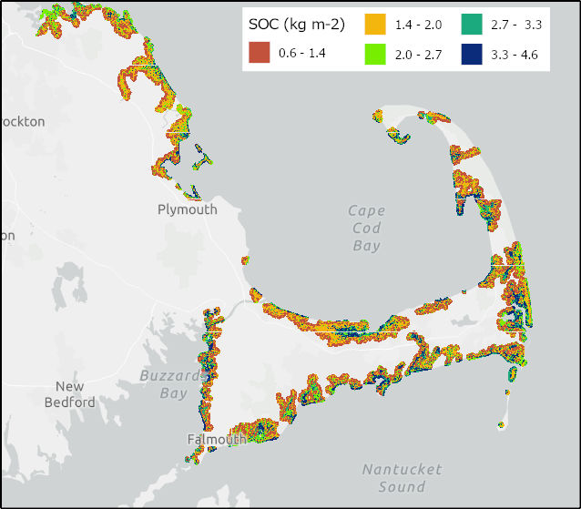
Federal
Soil Organic Carbon Distributions in Tidal Wetlands of the Northeastern USA
National Aeronautics and Space Administration —
This dataset provides estimates of soil organic carbon (SOC) in tidal wetlands for the northeastern United States. The data cover the period 1998-2018. Northeastern... -
Federal
NOAA Office for Coastal Management Coastal Inundation Digital Elevation Model: Texas North 1
National Oceanic and Atmospheric Administration, Department of Commerce —
These data were created as part of the National Oceanic and Atmospheric Administration Office for Coastal Management's efforts to create an online mapping viewer... -
Federal
EAARL-B Submerged Topography - Saint Croix and Saint Thomas, U.S. Virgin Islands, 2014
National Oceanic and Atmospheric Administration, Department of Commerce —
Binary point-cloud data for part of the submerged environs of Saint Croix and Saint Thomas, U.S. Virgin Islands, were produced from remotely sensed, geographically... -
Federal
RapidScat Level 2B Climate Ocean Wind Vectors in 12.5km Footprints Version 2.0
National Aeronautics and Space Administration —
This dataset contains the RapidScat Level 2B 12.5km Version 2.0 Climate quality ocean surface wind vectors. The Level 2B wind vectors are binned on a 12.5 km Wind... -
Federal
QuikSCAT Level 1C Averaged Sigma-0 and Winds from Non-spinning Antenna Version 2.0
National Aeronautics and Space Administration —
This dataset is Version 2 of the geo-located and averaged Level 1B Sigma-0 measurements and wind retrievals from the SeaWinds on QuikSCAT platform, initiated in the... -
Federal
2013 NOAA Oahu Topographic Lidar
National Oceanic and Atmospheric Administration, Department of Commerce —
The Oahu, Hawaii Elevation Data Task Order involves collecting and delivering topographic elevation point data derived from multiple return light detection and...

Official websites use .gov
A
.gov website belongs to an official government
organization in the United States.
Secure .gov websites use HTTPS
A
lock (
) or https:// means you’ve safely connected to
the .gov website. Share sensitive information only on official,
secure websites.