
-
Federal
SWOT Level 2 Radiometer Brightness Temperatures and Troposphere Operational Data Product
National Aeronautics and Space Administration —
The SWOT Level 2 Radiometer Brightness Temperatures and Troposphere Operational Geophysical Data Record (OGDR) Version 1.0 dataset produced by the Surface Water and... -
Federal
SWOT Level 2 Radiometer Brightness Temperatures and Troposphere Operational Data Product Version D
National Aeronautics and Space Administration —
The SWOT Level 2 Radiometer Brightness Temperatures and Troposphere Operational Geophysical Data Record (OGDR) Version D dataset produced by the Surface Water and... -
Federal
NASA Web-Enabled Landsat Data CONUS 30m Composites over Seasonal Periods V001
National Aeronautics and Space Administration —
WELDUSSE.015 was decommissioned on December 2, 2019. Users are encouraged to use the improved monthly Global Web-Enabled Landsat Data (GWELD) Version 3, 3.1, and 3.2... -
Federal
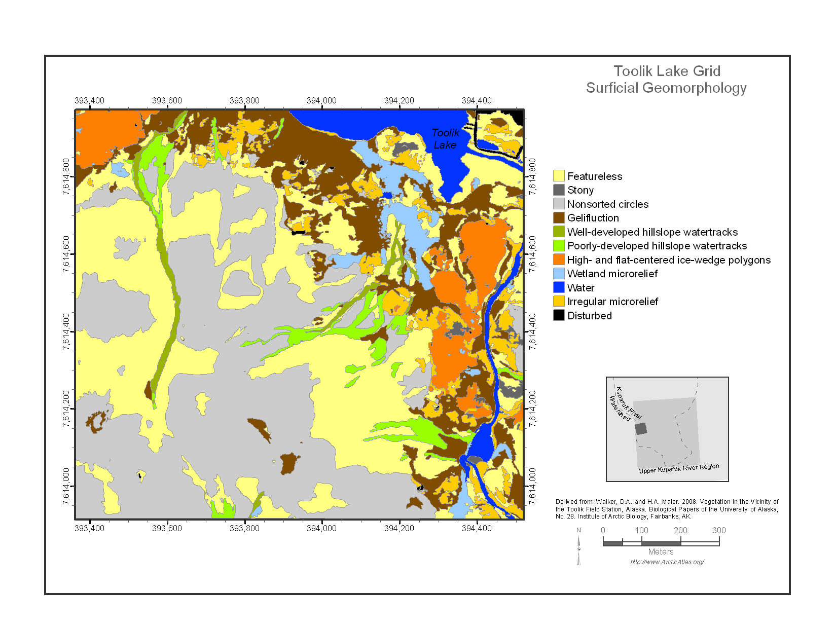
Maps of Vegetation Types and Physiographic Features, Toolik Lake Area, Alaska
National Aeronautics and Space Administration —
This data set provides the spatial distributions of vegetation types, soil carbon, and physiographic features in the Toolik Lake area, Alaska. Specific attributes... -
Federal
NASA Web-Enabled Landsat Data CONUS 30m Composites over Annual Periods V001
National Aeronautics and Space Administration —
WELDUSYR.015 was decommissioned on December 2, 2019. Users are encouraged to use the improved yearly Global Web-Enabled Landsat Data (GWELD) Version 3, 3.1, and 3.2... -
Federal
NASA Web-Enabled Landsat Data CONUS 30m Composites over Monthly Periods V001
National Aeronautics and Space Administration —
WELDUSMO.015 was decommissioned on December 2, 2019. Users are encouraged to use the improved monthly Global Web-Enabled Landsat Data (GWELD) Version 3, 3.1, and 3.2... -
Federal
NASA Web-Enabled Landsat Data Alaska 30m Composites over Weekly Periods V001
National Aeronautics and Space Administration —
WELDAKWK.015 was decommissioned on December 2, 2019. Users are encouraged to use the improved monthly Global Web-Enabled Landsat Data (GWELD) Version 3, 3.1, and 3.2... -
Federal
NASA Web-Enabled Landsat Data Alaska 30m Composites over Seasonal Periods V001
National Aeronautics and Space Administration —
WELDAKSE.015 was decommissioned on December 2, 2019. Users are encouraged to use the improved monthly Global Web-Enabled Landsat Data (GWELD) Version 3, 3.1, and 3.2... -
Federal
NASA Web-Enabled Landsat Data Alaska 30m Composites over Monthly Periods V001
National Aeronautics and Space Administration —
WELDAKMO.015 was decommissioned on December 2, 2019. Users are encouraged to use the improved monthly Global Web-Enabled Landsat Data (GWELD) Version 3, 3.1, and 3.2... -
Federal
SWOT Level 2 Radiometer Brightness Temperatures and Troposphere Interim Data Product Version D
National Aeronautics and Space Administration —
The SWOT Level 2 Radiometer Brightness Temperatures and Troposphere Interim Geophysical Data Record (IGDR) Version D dataset produced by the Surface Water and Ocean... -
Federal
SWOT Level 2 Radiometer Brightness Temperatures and Troposphere Interim Data Product
National Aeronautics and Space Administration —
The SWOT Level 2 Radiometer Brightness Temperatures and Troposphere Interim Geophysical Data Record (IGDR) Version 1.0 dataset produced by the Surface Water and Ocean... -
Federal
SHIFT: HyTES L1 Brightness Temperature, March 23 2022
National Aeronautics and Space Administration —
This dataset holds Level 1 (L1) brightness temperature data collected by the Hyperspectral Thermal Emission Spectrometer (HyTES) instrument. This imagery was acquired... -
Federal
SHIFT: HyTES L2 Geolocated Land Surface Temperature and Emissivity, March 23 2022
National Aeronautics and Space Administration —
This dataset holds Level 2 (L2) data for surface emissivity and land surface temperature (LST) collected by the Hyperspectral Thermal Emission Spectrometer (HyTES)... -
Federal
NASA Web-Enabled Landsat Data CONUS 30m Composites over Weekly Periods V001
National Aeronautics and Space Administration —
WELDUSWK.015 was decommissioned on December 2, 2019. Users are encouraged to use the improved monthly Global Web-Enabled Landsat Data (GWELD) Version 3, 3.1, and 3.2... -
Federal
NASA Web-Enabled Landsat Data Alaska 30m Composite Pixel Center Lat/Longs V001
National Aeronautics and Space Administration —
WELDAKLL.015 was decommissioned on December 2, 2019. Users are encouraged to use the improved monthly Global Web-Enabled Landsat Data (GWELD) Version 3, 3.1, and 3.2... -
Federal
NASA Web-Enabled Landsat Data Alaska 30m Composites over Annual Periods V001
National Aeronautics and Space Administration —
WELDAKYR.015 was decommissioned on December 2, 2019. Users are encouraged to use the improved yearly Global Web-Enabled Landsat Data (GWELD) Version 3, 3.1, and 3.2... -
Federal
NASA Web-Enabled Landsat Data CONUS 30m Composite Pixel Center Lat/Longs V001
National Aeronautics and Space Administration —
WELDUSLL.015 was decommissioned on December 2, 2019. Users are encouraged to use the improved monthly Global Web-Enabled Landsat Data (GWELD) Version 3, 3.1, and 3.2...

Official websites use .gov
A
.gov website belongs to an official government
organization in the United States.
Secure .gov websites use HTTPS
A
lock (
) or https:// means you’ve safely connected to
the .gov website. Share sensitive information only on official,
secure websites.