
-
Federal
SWOT Level 2 River Single-Pass Vector Data Product, Version D
National Aeronautics and Space Administration —
The SWOT Level 2 River Single-Pass Vector Data Product (SWOT_L2_HR_RiverSP_D) provides hydrologic measurements for predefined river reaches and nodes, derived from... -
Federal
MODIS/Terra Gross Primary Productivity Gap-Filled 8-Day L4 Global 500m SIN Grid V006
National Aeronautics and Space Administration —
The MOD17A2HGF Version 6 data product was decommissioned on July 31, 2023. Users are encouraged to use the MOD17A2HGF Version 6.1 data product.The MOD17A2HGF Version... -
Federal
MODIS/Terra Gross Primary Productivity Gap-Filled 8-Day L4 Global 500m SIN Grid V061
National Aeronautics and Space Administration —
The MOD17A2HGF Version 6.1 Gross Primary Productivity (GPP) product is a cumulative 8-day composite of values with 500 meter (m) pixel size based on the radiation use... -
Federal
Life Cycle Emissions Factors for Electricity Generation Technologies
Department of Energy —
This dataset consists of a table containing the distribution of literature estimates of greenhouse gas emissions for the following electricity generation and storage... -
Federal
VIIRS/NPP Actual and Potential Evapotranspiration Gap-Filled 8-Day L4 Global 500m SIN Grid V002
National Aeronautics and Space Administration —
The NASA/NOAA Suomi National Polar-orbiting Partnership (Suomi NPP) Visible Infrared Imaging Radiometer Suite (VIIRS) Actual and Potential Evapotranspiration product... -
Federal
SWOT Level 2 Water Mask Raster Image 100m Data Product, Version D
National Aeronautics and Space Administration —
The SWOT Level 2 KaRIn High Rate Raster Product (SWOT_L2_HR_Raster_D) provides rasterized estimates of water surface elevation, inundation extent, and radar... -
Federal
ARCTAS P-3B Aircraft AATS14 Data
National Aeronautics and Space Administration —
ARCTAS_AircraftRemoteSensing_P3B_AATS14_Data contains remotely sensed data collected via the Ames 14-Channel Airborne Tracking Sunphotometer (AATS14) onboard the P-3B... -
Federal
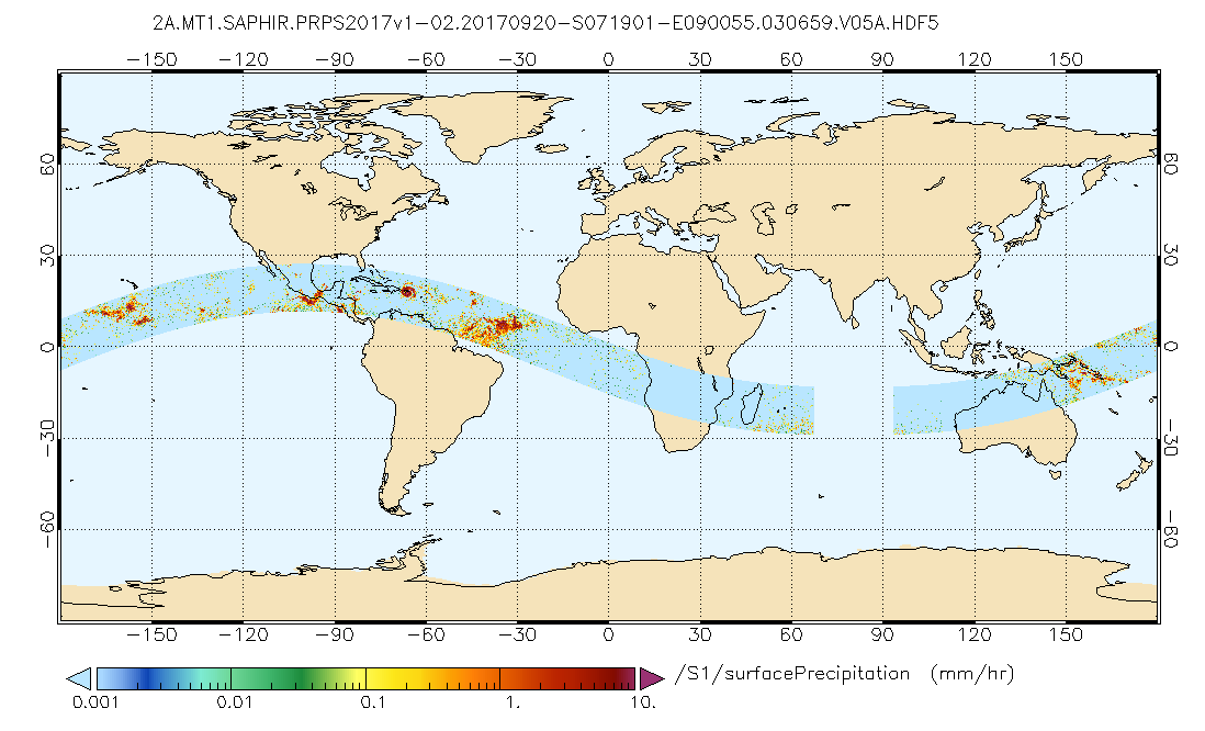
GPM SAPHIR on MT1 (PRPS) Climate-based Radiometer Precipitation Profiling L2 1.5 hours 10 km V06 (GPM_2APRPSMT1SAPHIR_CLIM) at GES DISC
National Aeronautics and Space Administration —
Version 6 is the current version of this dataset. Older versions are no longer available and have been superseded by Version 6.The Precipitation Retrieval and... -
Federal
ARCTAS DC-8 Aircraft In-situ Meteorological and Navigational Data
National Aeronautics and Space Administration —
ARCTAS_MetNav_AircraftInSitu_DC8_Data is the in-situ meteorological and navigational data for the DC-8 aircraft collected during the Arctic Research of the... -
Federal
SWOT Level 2 Water Mask Pixel Cloud Data Product, Version D
National Aeronautics and Space Administration —
The SWOT Level 2 Water Mask Pixel Cloud Product (SWOT_L2_HR_PIXC_D) provides high-resolution, geolocated observations of terrestrial surface water pixels detected by... -
Federal
MODIS/Aqua Gross Primary Productivity Gap-Filled 8-Day L4 Global 500m SIN Grid V061
National Aeronautics and Space Administration —
The MYD17A2HGF Version 6.1 Gross Primary Productivity (GPP) Gap-Filled product is a cumulative 8-day composite of values with 500 meter (m) pixel size based on the... -
Federal
Dynamics and Chemistry of the Summer Stratosphere Airborne Data Products
National Aeronautics and Space Administration —
DCOTSS-Aircraft-Data features the aircraft data collected during the Dynamics and Chemistry of the Summer Stratosphere sub-orbital campaign. These data products were... -
Federal
PEM Tropics B Satellite Data
National Aeronautics and Space Administration —
PEM-Tropics-B_Satellite_Data is the satellite data collected during the Pacific Exploratory Mission (PEM) Tropics B suborbital campaign. Data from the Geostationary... -
Federal
ARCTAS DC-8 Aircraft Merge Data
National Aeronautics and Space Administration —
ARCTAS_Merge_DC8_Aircraft_Data is the pre-generated merge files created from a variety of in-situ instrumentation collecting measurements onboard the DC-8 aircraft... -
Federal
SCOAPE-II R/V Point Sur Data
National Aeronautics and Space Administration —
SCOAPE2_RVPointSur_Data is the data collected from instruments onboard the University of Southern Mississippi’s Research Vessel (R/V) Point Sur during the Satellite... -
Federal
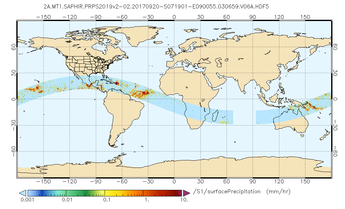
GPM SAPHIR on MT1 (PRPS) Radiometer Precipitation Profiling L2 1.5 hours 10 km V06 (GPM_2APRPSMT1SAPHIR) at GES DISC
National Aeronautics and Space Administration —
Version 6 is the current version of this dataset. Older versions are no longer available and have been superseded by Version 6.The Precipitation Retrieval and... -
Federal
JPL GRACE and GRACE-FO Mascon Ocean, Ice, and Hydrology Equivalent Water Height Coastal Resolution Improvement (CRI) Filtered Release 06.3 Version 04
National Aeronautics and Space Administration —
This dataset contains gridded monthly global water storage/height anomalies relative to a time-mean, derived from GRACE and GRACE-FO and processed at JPL using the... -
Federal
MODIS/Aqua Net Evapotranspiration Gap-Filled 8-Day L4 Global 500m SIN Grid V061
National Aeronautics and Space Administration —
The Aqua Moderate Resolution Imaging Spectroradiometer (MODIS) MYD16A2GF Version 6.1 Evapotranspiration/Latent Heat Flux (ET/LE) product is a year-end gap-filled... -
Federal
Remote sensing and field-based studies in the coastal Gulf of Alaska adjacent to the Copper River
National Aeronautics and Space Administration —
The coastal marine system of the Gulf of Alaska (GoA) is connected hydrologically, biogeochemically and biologically with the upriver systems of the Copper River... -
Federal
Pre-LBA ABLE-2A and ABLE-2B Expedition Data
National Aeronautics and Space Administration —
The ABLE 2A and 2B (Atmospheric Boundary Layer Experiments) data consists of estimates of the rate of exchange of a wide variety of aerosols and gases between the...

Official websites use .gov
A
.gov website belongs to an official government
organization in the United States.
Secure .gov websites use HTTPS
A
lock (
) or https:// means you’ve safely connected to
the .gov website. Share sensitive information only on official,
secure websites.