
-
Federal
NCDC International Best Track Archive for Climate Stewardship (IBTrACS) Project, Version 3 recent views
National Oceanic and Atmospheric Administration, Department of Commerce —
The International Best Track Archive for Climate Stewardship (IBTrACS) dataset was developed by the NOAA National Climatic Data Center, which took the initial step of... -
Federal
WaveWatch III (WW3) Global Wave Model recent views
National Oceanic and Atmospheric Administration, Department of Commerce —
Through a collaborative effort with NOAA/NCEP and NWS Honolulu, the University of Hawaii has implemented a global-scale WaveWatch III (WW3) 7-day model with a 5-day... -
Federal
Unexploded Ordnance Areas recent views
National Oceanic and Atmospheric Administration, Department of Commerce —
Unexploded ordnances (UXO) are explosive weapons (bombs, bullets, shells, grenades, mines, etc.) that did not explode when they were employed and still pose a risk of... -
Federal
Coastal Digital Elevation Models (DEMs) recent views
National Oceanic and Atmospheric Administration, Department of Commerce —
Digital elevation models (DEMs) of U.S. and other coasts that typically integrate ocean bathymetry and land topography. The DEMs support NOAA's mission to understand... -
Federal
Distance to Nearest Coastline: 0.01-Degree Grid recent views
National Oceanic and Atmospheric Administration, Department of Commerce —
A global data set of distances from the nearest coastline. Negative distances represent locations over land (including land-locked bodies of water), while positive... -
Federal
2021 NOAA NGS Topobathy Lidar: Gloucester, MA recent views
National Oceanic and Atmospheric Administration, Department of Commerce —
These data were collected by the National Oceanic Atmospheric Administration National Geodetic Survey Remote Sensing Division using a Leica Chiroptera 4X system. The... -
Federal
NOAA Electronic Navigational Charts (ENC) NGDA recent views
National Oceanic and Atmospheric Administration, Department of Commerce —
The Office of Coast Survey (OCS) has been involved in the development of a NOAA Electronic Navigational Chart (NOAA ENC) suite to support the marine transportation... -
Federal
Main Hawaiian Islands Multibeam Bathymetry Synthesis: 1-km Bathymetry and Topography recent views
National Oceanic and Atmospheric Administration, Department of Commerce —
A 50-m resolution gridded synthesis of all available bathymetry (ocean depth) data for the main Hawaiian Islands, from the Hawaii Mapping Research Group (HMRG) in the... -
Federal
Distance to Nearest Coastline: 0.04-Degree Grid recent views
National Oceanic and Atmospheric Administration, Department of Commerce —
A global data set of distances from the nearest coastline. Negative distances represent locations over land (including land-locked bodies of water), while positive... -
Federal
Regional Ocean Modeling System (ROMS): Western North Pacific: Data Assimilating recent views
National Oceanic and Atmospheric Administration, Department of Commerce —
Regional Ocean Modeling System (ROMS) 5-day, 3-hourly data assimilating hindcast for the region surrounding the Western North Pacific at approximately 8-km... -
Federal
NANOOS LiveOcean ROMS Model recent views
National Oceanic and Atmospheric Administration, Department of Commerce —
The experimental nowcast and forecast fields displayed here from LiveOcean are produced by a computer model of NE Pacific coastal ocean circulation. These coastal... -
Federal
2022 NOAA NGS Topobathy Lidar of Ta'u, American Samoa recent views
National Oceanic and Atmospheric Administration, Department of Commerce —
This data was collected by Woolpert using a Leica HawkEye 4X sensor. The data was acquired from 20221021 - 20221202. The data includes topobathy data in LAS 1.4... -
Federal
Near-Real Time Surface Ocean Velocity, Hawaii, 6 km Resolution recent views
National Oceanic and Atmospheric Administration, Department of Commerce —
Surface ocean velocities estimated from HF-Radar (HFR) are representative of the upper 0.3 - 2.5 meters of the ocean. The main objective of near-real time processing... -
Federal
gi_363-20180609T1949-delayed recent views
National Oceanic and Atmospheric Administration, Department of Commerce —
The Global component of the OOI includes arrays at critical, yet under-sampled, high-latitude locations such as within the Irminger Sea in the North Atlantic. The... -
Federal
2024 NOAA NGS Emergency Response Imagery: Hurricane Debby recent views
National Oceanic and Atmospheric Administration, Department of Commerce —
Aerial imagery was acquired following Hurricane Debby. The aerial photography missions were conducted by the NOAA Remote Sensing Division. The images were acquired... -
Federal
2006 NOAA Bathymetric Lidar: Puerto Rico (Southwest) recent views
National Oceanic and Atmospheric Administration, Department of Commerce —
This data set (Project Number OPR-I305-KRL-06) depicts depth values (mean 5 meter gridded) collected using LiDAR (Light Detection & Ranging) from the shoreline of... -
Federal
Fisheries Management Areas - Hawaii recent views
National Oceanic and Atmospheric Administration, Department of Commerce —
Boundaries of fisheries management areas (FMA) for the State of Hawaii. The mission of the Hawaii Division of Aquatic Resources (DAR) is to manage, conserve and... -
Federal
Bathymetric data collected by the U.S. Geological Survey and the National Oceanic and Atmospheric Administration offshore of Massachusetts between Duxbury and Hull (DH_bathy5m, Esri binary grid, UTM Zone 19, WGS84) recent views
Department of the Interior —
These data were collected under a cooperative agreement with the Massachusetts Office of Coastal Zone Management (CZM) and the U.S. Geological Survey (USGS), Coastal... -
Federal
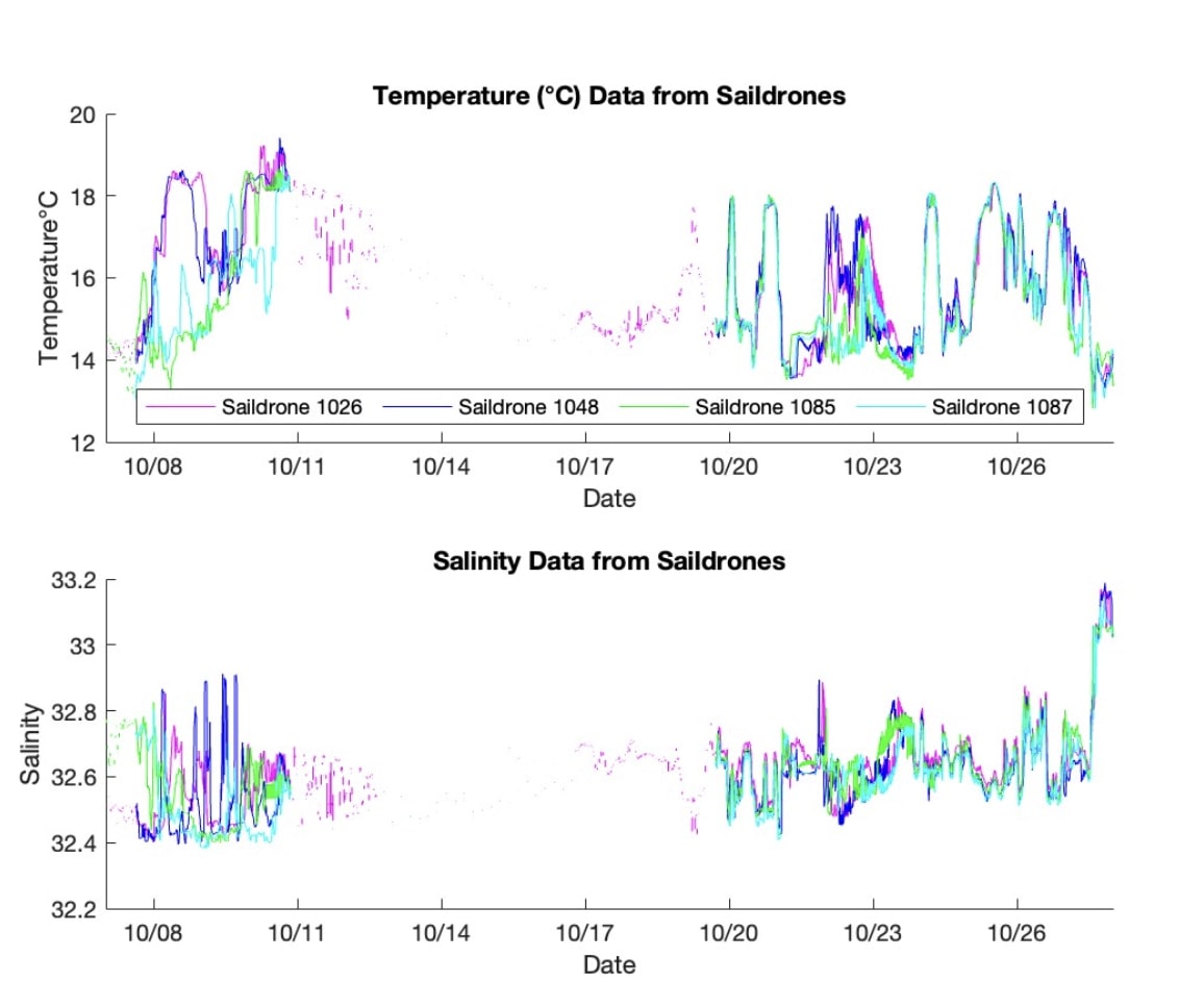
S-MODE L2 Temperature and Salinity from Saildrones Version 1 recent views
National Aeronautics and Space Administration —
This dataset contains Saildrone in-situ measurements taken during the Sub-Mesoscale Ocean Dynamics Experiment (S-MODE) conducted approximately 300 km offshore of San... -
Federal
Currents, HFRadar, SF Bay Outlet, Optimized Model, 2008, EXPERIMENTAL, Lon+/-180 recent views
National Oceanic and Atmospheric Administration, Department of Commerce —
The data is the zonal component of ocean surface currents derived from High Frequency Radio-derived measurements, with missing values filled in by a normal model....

Official websites use .gov
A
.gov website belongs to an official government
organization in the United States.
Secure .gov websites use HTTPS
A
lock (
) or https:// means you’ve safely connected to
the .gov website. Share sensitive information only on official,
secure websites.