
-
Federal
Linear Axis Testbed at IMS Center - Run-to-Failure Experiment 01
National Institute of Standards and Technology —
A linear axis testbed at the Center for Intelligent Maintenance Systems (IMS Center) at the University of Cincinnati was run to failure (the detection of backlash)... -
Federal
Global BUFR Data Stream: Ships and Buoy Observations from National Weather Service Telecommunications Gateway (NWS TG)
National Oceanic and Atmospheric Administration, Department of Commerce —
These are raw ship and buoy (moored and drifting) observations provided by World Meteorological Organization (WMO) Member States. Data are transmitted through the WMO... -
Federal
Data from: Eleven years of mountain weather, snow, soil moisture and stream flow data from the rain-snow transition zone - the Johnston Draw catchment, Reynolds Creek Experimental Watershed and Critical Zone Observatory, USA. v1.1
Department of Agriculture —
Detailed hydrometeorological data from the mountain rain-to-snow transition zone are present for water years 2004 through 2014. The Johnston Draw watershed (1.8 km2),... -
Federal
1995 Average Monthly Sea Surface Temperature for California
National Oceanic and Atmospheric Administration, Department of Commerce —
The NOAA/ NASA AVHRR Oceans Pathfinder sea surface temperature data are derived from the 5-channel Advanced Very High Resolution Radiometers (AVHRR) on board the NOAA... -
Federal
1998 Average Monthly Sea Surface Temperature for California
National Oceanic and Atmospheric Administration, Department of Commerce —
The NOAA/ NASA AVHRR Oceans Pathfinder sea surface temperature data are derived from the 5-channel Advanced Very High Resolution Radiometers (AVHRR) on board the NOAA... -
Federal
LBA-ECO TG-05 NPP, Carbon Pool, Soil Characteristics, Soil Gas Flux Maps of Brazil
National Aeronautics and Space Administration —
This data set provides maps produced from model output data from the National Aeronautics and Space Administration-Carnegie Ames Stanford Approach (NASA-CASA) model... -
Federal
LBA-ECO TG-07 Soil Trace Gas Fluxes km 67 Seca-Floresta Site, Tapajos National Forest
National Aeronautics and Space Administration —
Trace gas fluxes of carbon dioxide, methane, nitrous oxide, and nitric oxide (CO2, CH4, N2O, and NO) from surface soil were measured manually in an undisturbed forest... -
Federal
GPM SSMIS on F18 (GPROF) Climate-based Radiometer Precipitation Profiling L3 1 month 0.25 degree x 0.25 degree V07 (GPM_3GPROFF18SSMIS_CLIM) at GES DISC
National Aeronautics and Space Administration —
Version 07 is the current version of the data set. Older versions will no longer be available and have been superseded by Version 07. The "CLIM" products differ from... -
Federal
NOAA/WDS Paleoclimatology - Bigio fire data from Khorinsk Sawmill, Siberia - IMPD RUKHO001
National Oceanic and Atmospheric Administration, Department of Commerce —
This archived Paleoclimatology Study is available from the NOAA National Centers for Environmental Information (NCEI), under the World Data Service (WDS) for... -
Federal
MCC Country Program Data - FY25Q4 August
Millennium Challenge Corporation —
Cumulative program data for all of the Millennium Challenge Corporation's programs, including financial, conditions, and results data. -
Federal
Tide Model for the Hawaiian Islands: Main NW Islands
National Oceanic and Atmospheric Administration, Department of Commerce —
Tide model for the Hawaiian Islands. The model is based on climatological stratification, but 64 harmonics are used to model the full-depth baroclinic tides. The... -
Federal
Field Testing of an Unvented Roof with Fibrous Insulation, Tiles, and Vapor Diffusion Venting
Department of Energy —
BSC TO5 Task 2.5 Field Testing of an Un-vented Roof with Fibrous Insulation and Tiles - Winter Park, FL 32789 Field test data available for wood moisture contents,... -
Federal
2002 Average Monthly Sea Surface Temperature for California
National Oceanic and Atmospheric Administration, Department of Commerce —
The NOAA/ NASA AVHRR Oceans Pathfinder sea surface temperature data are derived from the 5-channel Advanced Very High Resolution Radiometers (AVHRR) on board the NOAA... -
Federal
ES60 Water Column Sonar Data Collected During GOA03SS
National Oceanic and Atmospheric Administration, Department of Commerce —
The third biennial bottom trawl survey of Gulf of Alaska (GOA) groundfish resources was conducted from May 20 through August 9, 2003, by the Resource Assessment and... -
Federal
2003 Average Monthly Sea Surface Temperature for California
National Oceanic and Atmospheric Administration, Department of Commerce —
The NOAA/ NASA AVHRR Oceans Pathfinder sea surface temperature data are derived from the 5-channel Advanced Very High Resolution Radiometers (AVHRR) on board the NOAA... -
Federal
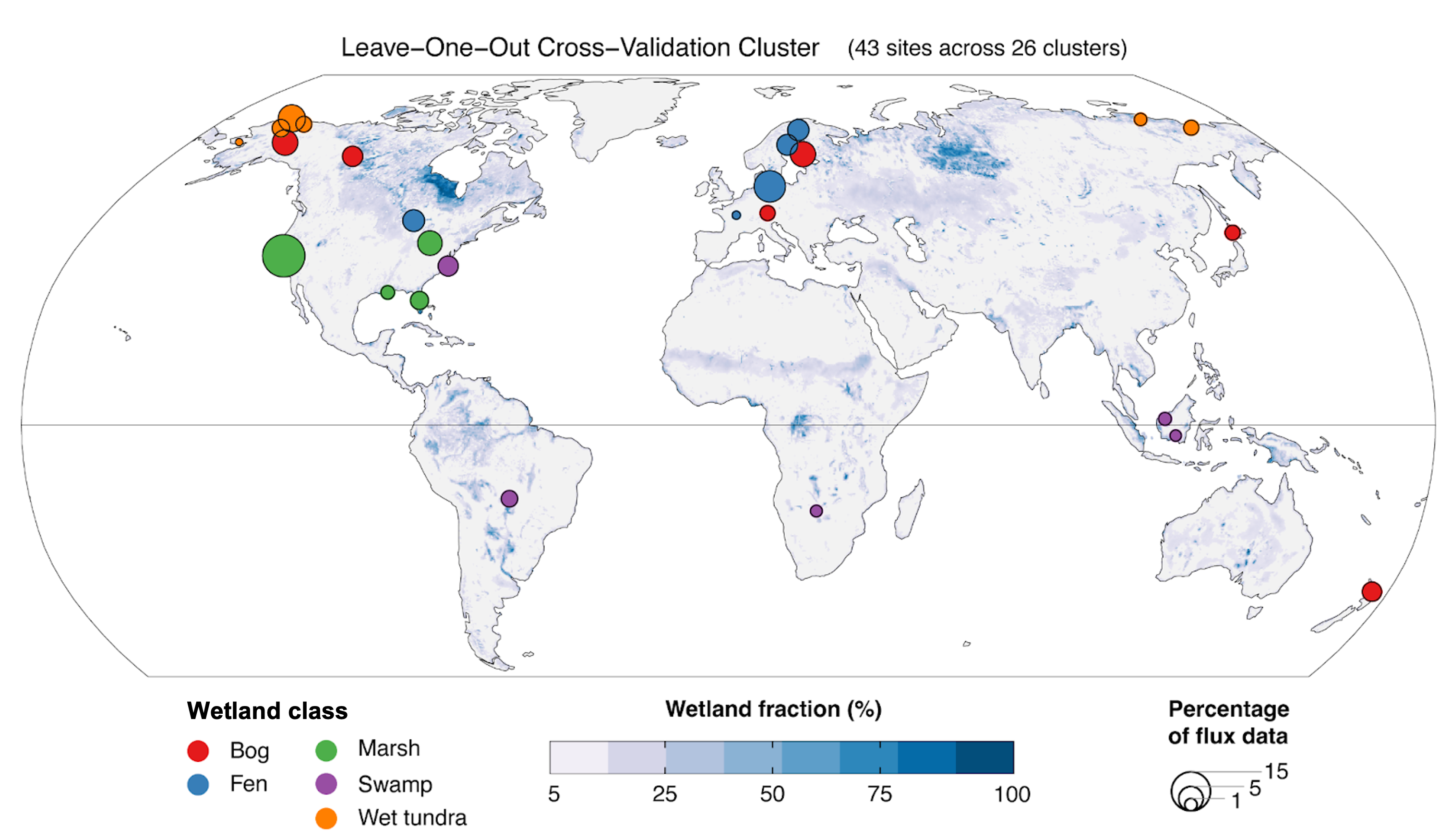
Global Wetland Methane Emissions derived from FLUXNET and the UpCH4 Model, 2001-2018
National Aeronautics and Space Administration —
This dataset provides monthly globally gridded freshwater wetland methane emissions from 2001-2018 in nmol CH4 m-2 s-1, g C-CH4 m-2 d-1, and TgCH4 grid cell-1... -
Federal
DSCOVR EPIC Level 1B Version 3
National Aeronautics and Space Administration —
Deep Space Climate Observatory (DSCOVR) Earth Polychromatic Imaging Camera (EPIC) is a 10-channel spectro-radiometer (317 – 780 nm) onboard National Oceanic and... -
Federal
ASTER L2 Surface Reflectance VNIR and Crosstalk Corrected SWIR V003
National Aeronautics and Space Administration —
The Terra Advanced Spaceborne Thermal Emission and Reflection Radiometer (ASTER) Surface Reflectance VNIR and Crosstalk Corrected SWIR (AST_07XT) dataset contains... -
Federal
ASTER L2 Surface Radiance - VNIR and Crosstalk Corrected SWIR V003
National Aeronautics and Space Administration —
The Terra Advanced Spaceborne Thermal Emission and Reflection Radiometer (ASTER) Surface Radiance VNIR and Crosstalk Corrected SWIR (AST_09XT) is a multi-file product... -
Federal
1996 Average Monthly Sea Surface Temperature for California
National Oceanic and Atmospheric Administration, Department of Commerce —
The NOAA/ NASA AVHRR Oceans Pathfinder sea surface temperature data are derived from the 5-channel Advanced Very High Resolution Radiometers (AVHRR) on board the NOAA...

Official websites use .gov
A
.gov website belongs to an official government
organization in the United States.
Secure .gov websites use HTTPS
A
lock (
) or https:// means you’ve safely connected to
the .gov website. Share sensitive information only on official,
secure websites.