

12 datasets found for "毕设ssm630无纸化学习平台的+vue毕业设计✅项目合作 二开均可 TG:saolei44✅.jlLAEsUmuZd"
-
Federal
McGrath (MCGR) Ground-based Vector Magnetic Field (L2) 0.5 s Data
National Aeronautics and Space Administration —
McGrath, AK, Ground-based Vector Magnetic Field Level 2 Data, 0.5 s Time Resolution, Station Code: (MCGR), Station Location: (GEO Latitude 63.0, Longitude 204.4),... -
Federal
SMEX02 SSM/I Brightness Temperature Data, Iowa, Version 1
National Aeronautics and Space Administration —
This data set provides brightness temperature data, acquired during the Soil Moisture Experiment 2002 (SMEX02) by the Special Sensor Microwave/Imagery (SSM/I). -
Federal
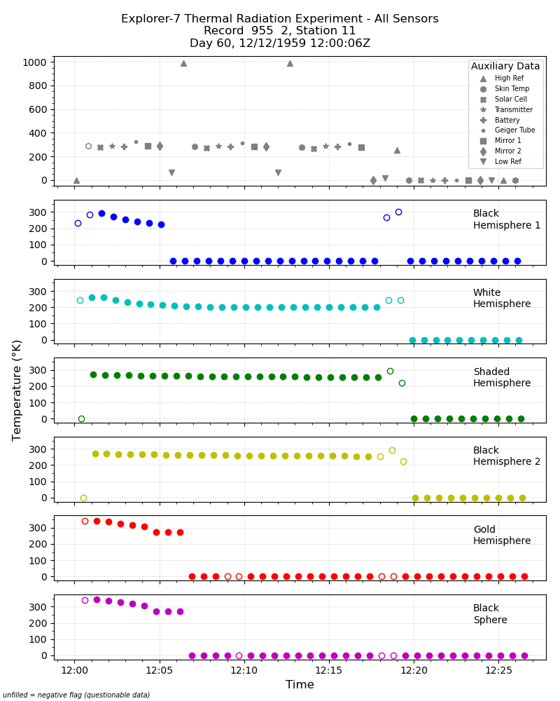
Explorer-7 Thermal Radiation Experiment Temperature Values from All Sensors V001 (EXP7L1TRTALL) at GES DISC
National Aeronautics and Space Administration —
Explorer-7 Thermal Radiation Experiment Temperature Values from All Sensors product contains temperature readings from all five bolometers in order to measure solar,... -
Federal
Swift-BAT 157-Month All-Sky Hard X-Ray Survey
National Aeronautics and Space Administration —
This catalog includes the hard X-ray sources detected in the first 157 months of observations with the Burst Alert Telescope (BAT) coded-mask imager on board the... -
Federal
Planck Catalog of Compact Sources 44GHz Catalog
National Aeronautics and Space Administration —
The Planck Catalogue of Compact Sources (PCCS) is a sample of reliable sources, both Galactic and extragalactic, extracted directly from the Planck nominal maps. The... -
Federal
MMS 4 Magnetic Ephemeris and Coordinates (MEC) and Support (Tsyganenko 1989 model, Quiet conditions), Level 2 (L2), Burst Mode, 30 ms Data
National Aeronautics and Space Administration —
Magnetospheric Multiscale 4 (MMS 4) spacecraft position, velocity, attitude, angular momentum vector, and magnetic ephemeris and coordinates (MEC), Level-2 science... -
Federal
Transcriptional analysis of thymus from mice flown on the RR-6 Mission
National Aeronautics and Space Administration —
The objective of the Rodent Research-6 (RR-6) study was to evaluate muscle atrophy in mice during spaceflight and to test the efficacy of a novel therapeutic to... -
Federal
NOAA-07 AVHRR Atmospherically Corrected Normalized Difference Vegetation Index Daily L3 Global 0.05 Deg. CMG
National Aeronautics and Space Administration —
The Long-Term Data Record (LTDR) produces, validates, and distributes a global land surface climate data record (CDR) that uses both mature and well-tested algorithms... -
Federal
GPM GROUND VALIDATION ADVANCED MICROWAVE RADIOMETER RAIN IDENTIFICATION (ADMIRARI) GCPEX V1
National Aeronautics and Space Administration —
The GPM Ground Validation Advanced Microwave Radiometer Rain Identification (ADMIRARI) GCPEx dataset measures brightness temperature at three frequencies (10.7, 21.0... -
Federal
Aquarius Official Release Level 3 Ancillary Reynolds Sea Surface Temperature Standard Mapped Image Ascending Mission Cumulative Data V5.0
National Aeronautics and Space Administration —
Aquarius Level 3 ancillary sea surface temperature (SST) standard mapped image data are the ancillary SST data used in the Aquarius calibration for salinity... -
Federal
Swift XRT Counterparts to Unidentified 1FGL Sources
National Aeronautics and Space Administration —
The authors have analyzed all the archival X-ray data of 134 unidentified (unID) gamma-ray sources listed in the first Fermi/LAT (1FGL) catalog and subsequently... -
Federal
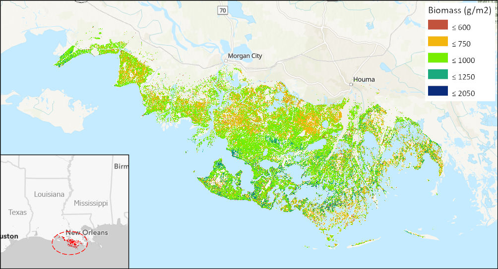
Aboveground Biomass High-Resolution Maps for Selected US Tidal Marshes, 2015
National Aeronautics and Space Administration —
This dataset provides maps of aboveground tidal marsh biomass (g/m2) at 30 m resolution for six estuarine regions of the conterminous United States: Cape Cod, MA;...
12 datasets found for "毕设ssm630无纸化学习平台的+vue毕业设计✅项目合作 二开均可 TG:saolei44✅.jlLAEsUmuZd"