

18 datasets found for "毕设ssm382航帆学院网站+vue毕业设计✅项目合作 二开均可 TG:saolei44✅.qCuGtRwRmYo"
-
Housing Finance Agency Portfolio
District of Columbia —
The DC Housing Finance Agency is the financial intermediary and administrator of affordable housing programs and resources for the District of Columbia. Through its... -
2014 Traffic Volume
District of Columbia —
Traffic volume of Roadway Blocks. The dataset contains traffic volume data, created as part of the District of Columbia, Department of Transportation (DDOT) Roads and... -
Federal
Isotope ratio mass spectrometry (IRMS) and spectroscopic techniques for microplastic characterization
U.S. Environmental Protection Agency —
The IRMS data set contains average d13c value comparisons of various polymer types. FTIR and micro-Raman spectroscopy data is also included that characterizes all... -
University
Lincoln County 2010 Census Roads
Earth Data Analysis Center, University of New Mexico —
The TIGER/Line Files are shapefiles and related database files (.dbf) that are an extract of selected geographic and cartographic information from the U.S. Census... -
Federal
LBA-ECO CD-04 Leaf Photosynthesis and Respiration, Tapajos National Forest: 2000-2006
National Aeronautics and Space Administration —
This data set reports the results of measurements of (1) leaf-level photosynthesis response curves for the effects of temperature, leaf age, warming, irradiation, and... -
Federal
SAFARI 2000 AVHRR-derived Land Surface Temperature Maps, Africa, 1995-2000
National Aeronautics and Space Administration —
Land Surface Temperature (LST) is a key indicator of land surface states, and can provide information on surface-atmosphere heat and mass fluxes, vegetation water... -
Federal
Global Distribution of Root Profiles in Terrestrial Ecosystems
National Aeronautics and Space Administration —
Rooting depths were estimated from a global database of root profiles that was assembled from the primary literature to study relationships of abiotic and biotic... -
Federal
AbsorbanceQ App for Generating Absorbance Images from Brightfield Image Captures
Department of Commerce —
This page hosts the AbsorbanceQ app which generates absorbance images from brightfield image captures. Absorbance microscopy can be used to make trypan blue cell... -
Obstructed Areas
District of Columbia —
Obscured Areas are areas in the compilation imagery that due to shadows, dense vegetation, heavy tree cover, building lean, etc., that completely block out all image... -
State
Providers Delivering Family Planning, Access, Care, and Treatment (PACT) Services, by Fiscal Years
State of California —
This data file contains information on the number of providers delivering services through the Family Planning, Access, Care, and Treatment (Family PACT) Program from... -
Federal
ALFA Wave Resource Characterization in Extreme Conditions, Offshore of Newport, OR
Department of Energy —
Model hindcast and Surface Wave Instrument Float With Tracking (SWIFT) buoy observations during extreme conditions offshore of Newport, OR -
Federal
BOREAS TGB-03 Plant Species Composition Data over the NSA Fen
National Aeronautics and Space Administration —
The BOREAS TGB-03 team collected several data sets that contributed to understanding the measured trace gas fluxes over sites in the NSA. This data set contains... -
City
SPU DWW Proposed Mainline End Points
City of Seattle —
SPU DWW Mainline Points is a Group Layer containing all Lifecycles, Ownerships, and other variations of Drainage and Wastewater Mainlines Points.Proposed Mainline End... -
Federal
LBA-ECO ND-11 Pre-harvest Forest Tree and Liana Biomass, NW Mato Grosso, Brazil: 2003
National Aeronautics and Space Administration —
The purpose of this study was to determine if spatially-explicit commercial timber inventories (CTI) could be used in conjunction with satellite imagery to improve... -
Federal
LBA-ECO LC-02 Hot Pixel Fire Indicator Data for Tri-national MAP Region: 2003-2006
National Aeronautics and Space Administration —
This data set provides hot pixel data, as an indicator of fires, that were detected by various satellites in the tri-national MAP region (Madre de Dios-Peru, Acre-... -
Federal
LBA-ECO ND-08 Biomass, Nutrients, and Decomposition in Eucalyptus and Primary Forests
National Aeronautics and Space Administration —
This data set reports the concentrations of the nutrients nitrogen (N), phosphorus (P), magnesium (Mg), calcium (Ca), and potassium (K) in roots, litterfall, leaves,... -
Federal
SAFARI 2000 Hydrographic Data, 1-Deg, Release 2.2 (Cogley)
National Aeronautics and Space Administration —
This southern African subset of the Global Hydrographic data set (GGHYDRO) Release 2.2 is organized into 19 files containing terrain type, stream frequency counts,... -
Federal
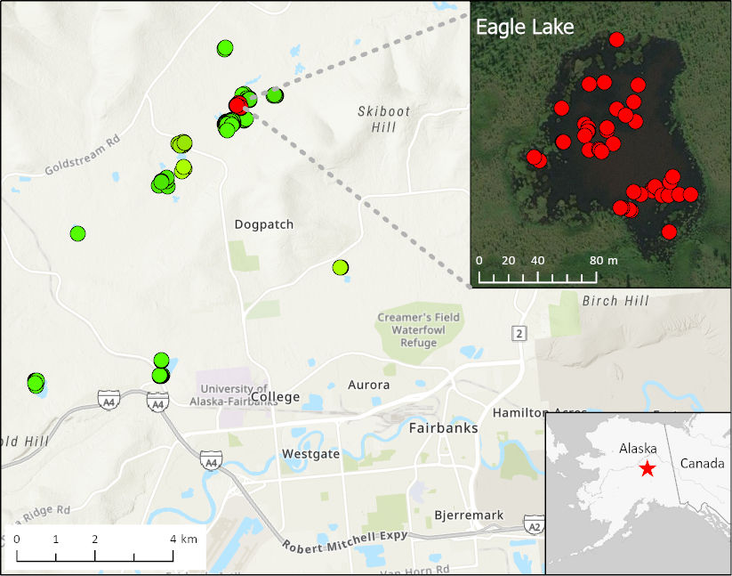
ABoVE: Methane Ebullition Hotspots in Frozen Lakes near Fairbanks, Alaska, Oct 2014
National Aeronautics and Space Administration —
This dataset includes maps of the locations and number of methane ebullition hotspots in 15 frozen lakes in the southern portion of the Goldstream Valley and the...
18 datasets found for "毕设ssm382航帆学院网站+vue毕业设计✅项目合作 二开均可 TG:saolei44✅.qCuGtRwRmYo"