

15 datasets found for "⑁카톡892jms☑️상조내구제"
-
Federal
AQUA MODIS High Resolution Level 3 daily aerosol data, 0.1x0.1 degree grid Version 001 (AER_DBDT_D10KM_L3_MODIS_AQUA) at GES DISC
National Aeronautics and Space Administration —
This High-Resolution (0.1 x 0.1 degree) Level 3 daily Aerosol Optical Depth (AOD) product is generated by combining two Moderate Resolution Imaging Spectroradiometer... -
Federal
Data for Filtering Organized 3D Point Clouds for Bin Picking Applications
National Institute of Standards and Technology —
Contains scans of a bin filled with different parts ( screws, nuts, rods, spheres, sprockets). For each part type, RGB image and organized 3D point cloud obtained... -
Federal
Global 1-km Gridded Thickness of Soil, Regolith, and Sedimentary Deposit Layers
National Aeronautics and Space Administration —
This data set provides high-resolution estimates of the thickness of the permeable layers above bedrock (soil, regolith, and sedimentary deposits) within a global... -
Federal
THIR/Nimbus-7 Level 1 Cloud Data for SBUV/TOMS V001 (THIRN7L1BCLT) at GES DISC
National Aeronautics and Space Administration —
THIRN7L1BCLT is the Nimbus-7 Temperature-Humidity Infrared Radiometer (THIR) Level 1 Cloud Data for SBUV/TOMS (BCLT) product and contains total cloud amounts;... -
Federal
BOREAS TE-06 Predawn Leaf Water Potentials and Foliage Moisture Content Data
National Aeronautics and Space Administration —
The BOREAS TE-06 team collected several data sets to examine the influence of vegetation, climate, and their interactions on the major carbon fluxes for boreal forest... -
Federal
NOAA/WDS Paleoclimatology - Heyerdahl fire data from Black Bear, central Oregon - IMPD USBEE002
National Oceanic and Atmospheric Administration, Department of Commerce —
This archived Paleoclimatology Study is available from the NOAA National Centers for Environmental Information (NCEI), under the World Data Service (WDS) for... -
Federal
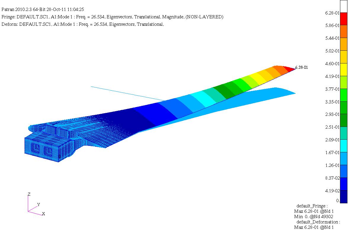
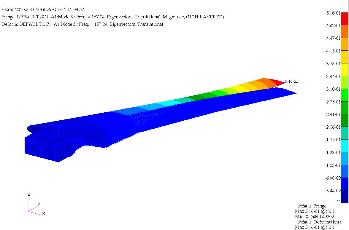
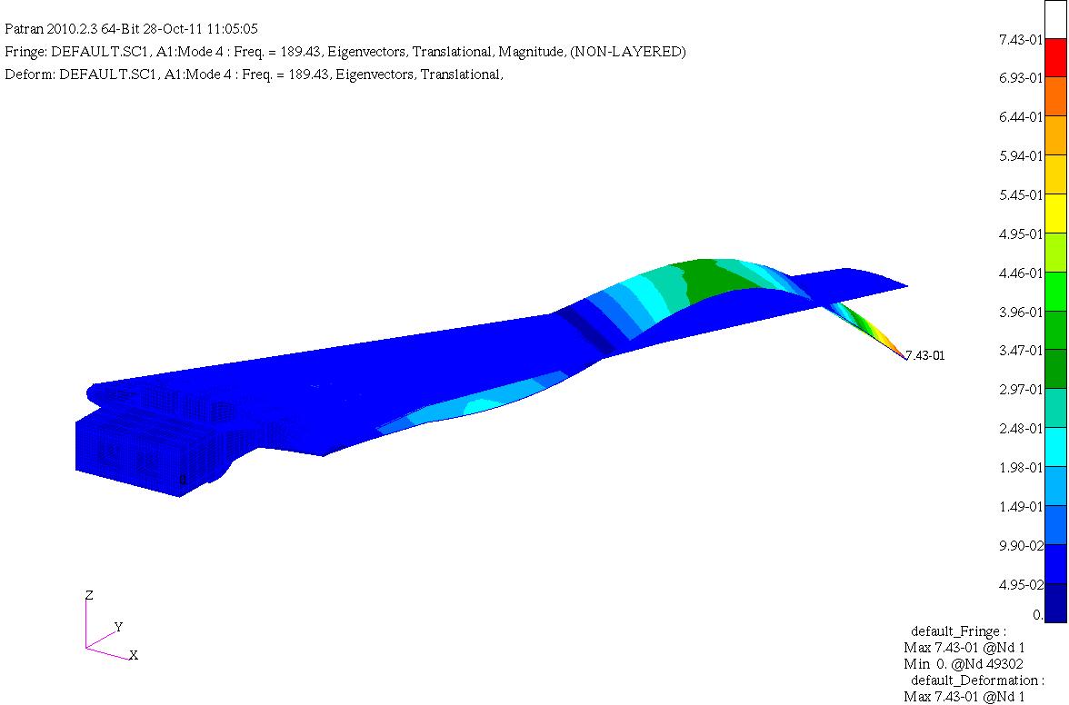
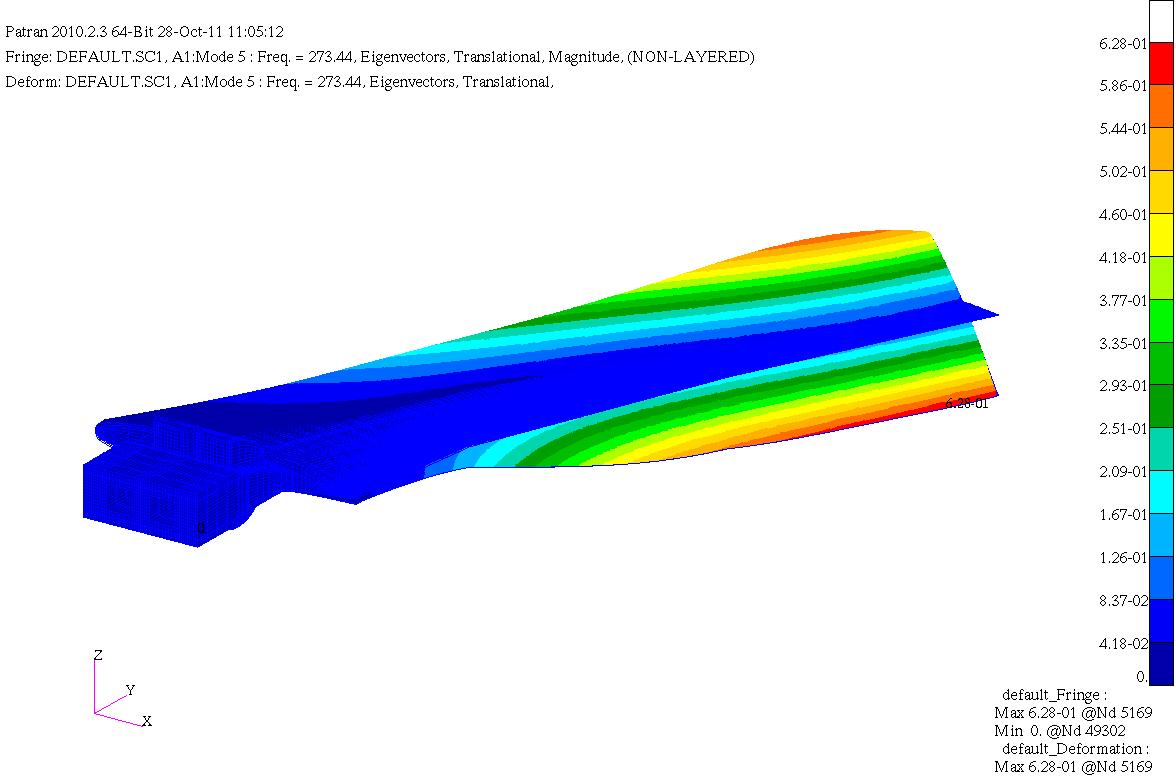
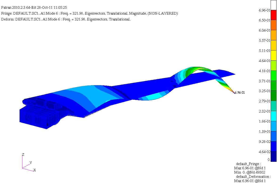
HIRENASD Comparisons of FEM modal frequencies and modeshapes
National Aeronautics and Space Administration —
Below are frequency comparisons of different models with experiment Note Modeshapes aren't very descriptive for higher modes. There is coupling between them so this... -
Federal
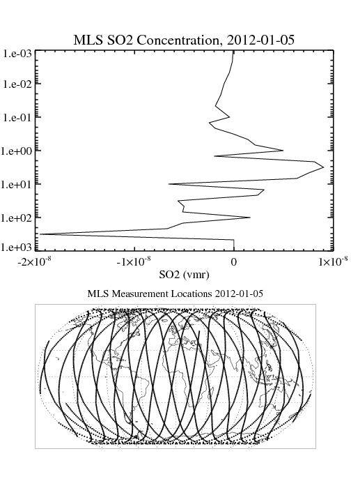
MLS/Aura Level 2 Sulfur Dioxide (SO2) Mixing Ratio V004 (ML2SO2) at GES DISC
National Aeronautics and Space Administration —
ML2SO2 is the EOS Aura Microwave Limb Sounder (MLS) standard product for sulfur dioxide derived from radiances measured by the 240 GHz radiometer. The data version is... -
Federal
TROPICS03 L1A Orbital Geolocated Native-Resolution Antenna Temperatures V1.0
National Aeronautics and Space Administration —
The "Time-Resolved Observations of Precipitation structure and storm Intensity with a Constellation of Smallsats" (TROPICS) mission has a goal of providing nearly... -
Federal
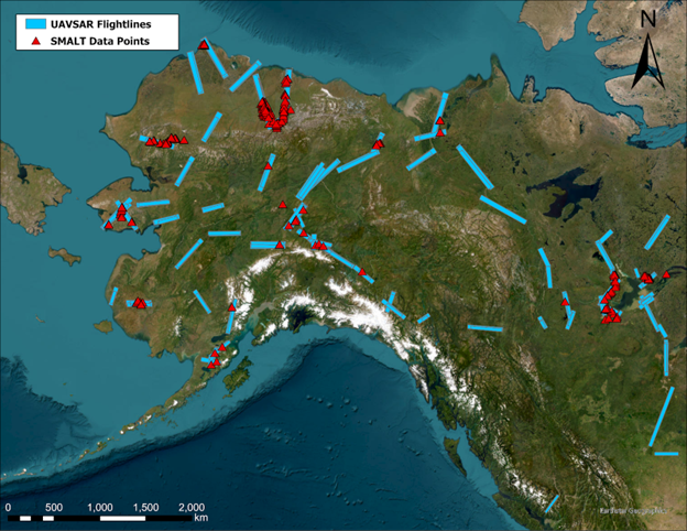
ABoVE: Soil Moisture and Active Layer Thickness in Alaska, USA and Canada, 2005-2022
National Aeronautics and Space Administration —
This dataset provides soil thaw depth and moisture measurements and dielectric properties measured by different research teams at sites in Alaska, U.S., and the... -
Federal
MODIS NDVI Data, Smoothed and Gap-filled, for the Conterminous US: 2000-2015
National Aeronautics and Space Administration —
This data set provides Moderate Resolution Imaging Spectroradiometer (MODIS) normalized difference vegetation index (NDVI) data, smoothed and gap-filled, for the... -
Federal
TROPESS CrIS-SNPP L2 Carbon Monoxide for West Coast Fires, Standard Product V1 (TRPSDL2COCRSWCF) at GES DISC
National Aeronautics and Space Administration —
The TROPESS CrIS-SNPP L2 Carbon Monoxide for West Coast Fires, Standard Product contains the vertical distribution of the retrieved atmospheric state of carbon... -
Federal
OMPS-NPP L2 LP Aerosol Extinction Vertical Profile swath daily 3slit V2 (OMPS_NPP_LP_L2_AER_DAILY) at GES DISC
National Aeronautics and Space Administration —
The OMPS-NPP L2 LP Aerosol Extinction Vertical Profile swath daily 3slit (AER) product contains the retrieved aerosol extinction coefficients measured by the Ozone... -
Federal
AirMOSS: L1 S-0 Polarimetric Data from AirMOSS P-band SAR, Metolius, 2012-2015
National Aeronautics and Space Administration —
This data set provides level 1 (L1) polarimetric radar backscattering coefficient (sigma-0), multilook complex, polarimetrically calibrated, and georeferenced data... -
Federal
GEWEX SRB Integrated Product (Rel-4_1) Longwave Daily Average by Local Fluxes
National Aeronautics and Space Administration —
GEWEXSRB_Rel4_1-IP_Longwave_daily_local is the Global Energy and Water Exchanges (GEWEX) Surface Radiation Budget (SRB) Integrated Product (Rel-4) Longwave Daily...
15 datasets found for "⑁카톡892jms☑️상조내구제"