
-
University
Cadastral PLSS Standardized Data - PLSSReferenceGrid, NE - Version 1.1
Earth Data Analysis Center, University of New Mexico —
This feature class is part of the Cadastral National Spatial Data Infrastructure (NSDI) CADNSDI publication data set for rectangular and non-rectangular Public Land... -
University
Cadastral PLSS Standardized Data - PLSSQuarterReference, NW - Version 1.1
Earth Data Analysis Center, University of New Mexico —
This feature class is part of the Cadastral National Spatial Data Infrastructure (NSDI) CADNSDI publication data set for rectangular and non-rectangular Public Land... -
University
Cadastral PLSS Standardized Data - PLSSQuarterReference, SW - Version 1.1
Earth Data Analysis Center, University of New Mexico —
This feature class is part of the Cadastral National Spatial Data Infrastructure (NSDI) CADNSDI publication data set for rectangular and non-rectangular Public Land... -
City
GIS Map Panel Boundaries
City of Bloomington —
This map data layer represents the GIS Map Panel Boundaries for the City of Bloomington, Indiana. The GIS Map Panel Boundaries data layer was created as a reference... -
University
Cadastral PLSS Standardized Data - PLSSQuarterReference, SE - Version 1.1
Earth Data Analysis Center, University of New Mexico —
This feature class is part of the Cadastral National Spatial Data Infrastructure (NSDI) CADNSDI publication data set for rectangular and non-rectangular Public Land... -
University
Cadastral PLSS Standardized Data - PLSSQuarterReference, NE - Version 1.1
Earth Data Analysis Center, University of New Mexico —
This feature class is part of the Cadastral National Spatial Data Infrastructure (NSDI) CADNSDI publication data set for rectangular and non-rectangular Public Land... -
Federal
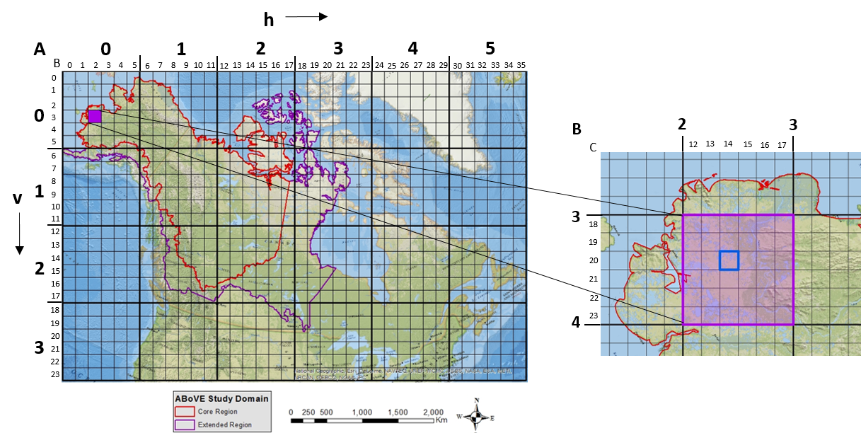
ABoVE: Study Domain and Standard Reference Grids
National Aeronautics and Space Administration —
The Arctic - Boreal Vulnerability Experiment (ABoVE) has developed two standardized spatial data products to expedite coordination of research activities and to... -
Federal
1:6000 Scale (6K) Quadrangles developed by USEPA to Support Reconnaissance, and Tactical and Strategic Planning for Emergency Responses and Homeland Security Events (Region 4 Extract)
U.S. Environmental Protection Agency —
Reference quads for emergency response reconnaissance developed for use by the US Environmental Protection Agency. Grid cells are based on densification of the USGS... -
Federal
1:6000 Scale (6K) Quadrangles developed by USEPA to Support Reconnaissance, and Tactical and Strategic Planning for Emergency Responses and Homeland Security Events (Region 1 Extract)
U.S. Environmental Protection Agency —
Reference quads for emergency response reconnaissance developed for use by the US Environmental Protection Agency. Grid cells are based on densification of the USGS... -
Federal
1:6000 Scale (6K) Quadrangles developed by USEPA to Support Reconnaissance, and Tactical and Strategic Planning for Emergency Responses and Homeland Security Events (Downloadable Data)
U.S. Environmental Protection Agency —
Reference quads for emergency response reconnaissance developed for use by the US Environmental Protection Agency. Grid cells are based on densification of the USGS... -
Federal
1:6000 Scale (6K) Quadrangles developed by USEPA to Support Reconnaissance, and Tactical and Strategic Planning for Emergency Responses and Homeland Security Events (Region 8 Extract)
U.S. Environmental Protection Agency —
Reference quads for emergency response reconnaissance developed for use by the US Environmental Protection Agency. Grid cells are based on densification of the USGS... -
University
Cadastral PLSS Standardized Data - PLSSReferenceGrid, SW - Version 1.1
Earth Data Analysis Center, University of New Mexico —
This feature class is part of the Cadastral National Spatial Data Infrastructure (NSDI) CADNSDI publication data set for rectangular and non-rectangular Public Land... -
Federal
ABoVE: Study Domain and Standard Reference Grids, Version 2
National Aeronautics and Space Administration —
The Arctic - Boreal Vulnerability Experiment (ABoVE) has developed two standardized spatial data products to expedite coordination of research activities and to... -
Federal
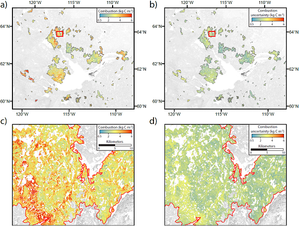
ABoVE: Wildfire Carbon Emissions and Burned Plot Characteristics, NWT, CA, 2014-2016
National Aeronautics and Space Administration —
This dataset provides estimates of wildfire carbon emissions and uncertainties at 30-m resolution, and measurements collected at burned and unburned field plots from... -
University
Cadastral PLSS Standardized Data - PLSSReferenceGrid, NW - Version 1.1
Earth Data Analysis Center, University of New Mexico —
This feature class is part of the Cadastral National Spatial Data Infrastructure (NSDI) CADNSDI publication data set for rectangular and non-rectangular Public Land... -
University
Cadastral PLSS Standardized Data - PLSSReferenceGrid, SE - Version 1.1
Earth Data Analysis Center, University of New Mexico —
This feature class is part of the Cadastral National Spatial Data Infrastructure (NSDI) CADNSDI publication data set for rectangular and non-rectangular Public Land... -
Federal
1:6000 Scale (6K) Quadrangles developed by USEPA to Support Reconnaissance, and Tactical and Strategic Planning for Emergency Responses and Homeland Security Events (Region 5 Extract)
U.S. Environmental Protection Agency —
Reference quads for emergency response reconnaissance developed for use by the US Environmental Protection Agency. Grid cells are based on densification of the USGS... -
Federal
1:6000 Scale (6K) Quadrangles developed by USEPA to Support Reconnaissance, and Tactical and Strategic Planning for Emergency Responses and Homeland Security Events (Region 7 Extract)
U.S. Environmental Protection Agency —
Reference quads for emergency response reconnaissance developed for use by the US Environmental Protection Agency. Grid cells are based on densification of the USGS... -
Federal
1:6000 Scale (6K) Quadrangles developed by USEPA to Support Reconnaissance, and Tactical and Strategic Planning for Emergency Responses and Homeland Security Events (Region 6 Extract)
U.S. Environmental Protection Agency —
Reference quads for emergency response reconnaissance developed for use by the US Environmental Protection Agency. Grid cells are based on densification of the USGS... -
Federal
1:6000 Scale (6K) Quadrangles developed by USEPA to Support Reconnaissance, and Tactical and Strategic Planning for Emergency Responses and Homeland Security Events (Region 10 Extract)
U.S. Environmental Protection Agency —
Reference quads for emergency response reconnaissance developed for use by the US Environmental Protection Agency. Grid cells are based on densification of the USGS...

Official websites use .gov
A
.gov website belongs to an official government
organization in the United States.
Secure .gov websites use HTTPS
A
lock (
) or https:// means you’ve safely connected to
the .gov website. Share sensitive information only on official,
secure websites.