

12 datasets found for ""Agricultural Inventory""
-
Federal
Department of Agriculture Inventory of Artificial Intelligence Use Cases
Department of Agriculture —
This dataset is an inventory of the uses of artificial intelligence (AI) at USDA. The inventory was developed and published as required by OMB M-24-10, "Advancing... -
Federal
Global Agricultural Lands: Croplands, 2000
National Aeronautics and Space Administration —
The Global Croplands data set represents the proportion of land areas used as cropland (land used for the cultivation of food) in the year 2000. Satellite data from... -
State
Vegetation - Central Valley Flood Protection Planning Area Update - 2016 [ds2890]
State of California —
The Department of Water Resources hired the GIC in early 2010 to complete a riparian vegetation map of the Central Valley Flood Protection Plan’s (CVFPP) footprint.... -
State
Vegetation - Great Valley Ecoregion [ds2632]
State of California —
Geodatabase feature class containing a map of vegetation within the Great Valley Ecoregion produced by the Geographical Information Center (GIC) at CSU Chico. The... -
State
Vegetation - Delta Vegetation and Land Use Update - 2016 [ds2855]
State of California —
The Sacramento-San Joaquin Delta Reform Act of 2009 established the Delta Stewardship Council (DSC) to achieve more effective governance while providing for the... -
Federal
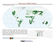
Global Agricultural Lands: Pastures, 2000
National Aeronautics and Space Administration —
The Global Pastures data set represents the proportion of land areas used as pasture land (land used to support grazing animals) in the year 2000. Satellite data from... -
State
Vegetation - Lower Feather River Update - 2018 [ds2891]
State of California —
The Feather River was mapped using 2018 National Agricultural Inventory Program (NAIP) imagery, and using a classification developed by the California Native Plant... -
State
Vegetation - Springtown Alkali Sink [ds2965]
State of California —
The University of California Berkeley Herbarium contracted Aerial Information Systems, Inc. in 2008 to create a baseline inventory of wetlands and associated upland... -
Federal
A NAIP and Sentinel-2 based quantification of fractional composition of unvegetated, vegetated, and water in the Pacific Coast, 2014-2019 used for calibration and validation of Landsat based datasets
Department of the Interior —
These datasets were created from high-resolution (1-m) datasets representing median conditions during a 2014-2019 time period. These datasets used National... -
Federal
A NAIP and Sentinel-2 based quantification of fractional composition of unvegetated, vegetated, and water in the conterminous United States, 2014-2019 used for calibration and validation of Landsat based datasets
Department of the Interior —
These datasets were created from high-resolution (1-m) datasets representing median conditions during a 2014-2019 time period. These datasets used National... -
Federal
A NAIP and Sentinel-2 based quantification of fractional composition of unvegetated, vegetated, and water in the Atlantic Coast, 2014-2019 used for calibration and validation of Landsat based datasets
Department of the Interior —
These datasets were created from high-resolution (1-m) datasets representing median conditions during a 2014-2019 time period. These datasets used National... -
Federal
A NAIP and Sentinel-2 based quantification of fractional composition of unvegetated, vegetated, and water in the Gulf of Mexico Coast, 2014-2019 used for calibration and validation of Landsat based datasets
Department of the Interior —
These datasets were created from high-resolution (1-m) datasets representing median conditions during a 2014-2019 time period. These datasets used National...
12 datasets found for ""Agricultural Inventory""