
-
Federal
Global Vegetation Greenness (NDVI) from AVHRR GIMMS-3G+, 1981-2022
National Aeronautics and Space Administration —
This dataset holds the Global Inventory Modeling and Mapping Studies-3rd Generation V1.2 (GIMMS-3G+) data for the Normalized Difference Vegetation Index (NDVI). NDVI... -
Federal
NACP Aboveground Biomass and Carbon Baseline Data, V.2 (NBCD 2000), U.S.A., 2000
National Aeronautics and Space Administration —
The NBCD 2000 (National Biomass and Carbon Dataset for the Year 2000) data set provides a high-resolution (30 m) map of year-2000 baseline estimates of basal area-... -
Federal
Global Historical Climatology Network, 1753-1990
National Aeronautics and Space Administration —
This data set contains monthly temperature, precipitation, sea-level pressure, and station-pressure data for thousands of meteorological stations worldwide. The... -
Federal
LBA-ECO LC-08 Soil, Vegetation, and Land Cover Maps for Brazil and South America
National Aeronautics and Space Administration —
This data set provides (1) soil maps for Brazil that are digital versions of the MAPA DE SOLOS DO BRASIL (EMBRAPA, 1981) classified at three levels of detail,... -
Federal
LBA-ECO LC-01 Landsat TM Land Use/Land Cover, Northern Ecuadorian Amazon: 1986-1999
National Aeronautics and Space Administration —
This data set contains Landsat TM imagery for the years 1986, 1989, 1996, and 1999, that have been classified into four land use/land cover (LULC) classes: Forest,... -
Federal
VEMAP 1: U.S. Site Files
National Aeronautics and Space Administration —
The Vegetation/Ecosystem Modeling and Analysis Project (VEMAP) is an ongoing multiinstitutional, international effort addressing the response of biogeography and... -
Federal
BOREAS RSS-10 TOMS Circumpolar One-Degree PAR Images
National Aeronautics and Space Administration —
The BOREAS RSS-10 team investigated the magnitude of daily, seasonal, and yearly variations of PAR from ground and satellite observations. This data set contains... -
Federal
ABoVE: Thaw Depth at Selected Unburned and Burned Sites Across Alaska
National Aeronautics and Space Administration —
This dataset provides thaw depth measurements made at seven locations across Alaska, during August 2016, June and September 2017, and July-August 2018. Three of the... -
Federal
MASTER: Costa Rica Airborne Research and Technology Applications (CARTA), 2005
National Aeronautics and Space Administration —
This dataset includes Level 1B (L1B) data products from the MODIS/ASTER Airborne Simulator (MASTER) instrument. The spectral data were collected during 23 flights... -
Federal
Eddy Corr. Surface Flux: ANL (FIFE)
National Aeronautics and Space Administration —
The Eddy Correlation Surface Flux Observations (Argonne) Data Set contains surface flux measurements made at selected sites within the FIFE study area. The surface... -
Federal
ABoVE: White Spruce Photosynthetic and Leaf Traits, Alaska and New York, 2017
National Aeronautics and Space Administration —
This dataset provides measurements of gas exchange (light response curves, Kok curves and ACi curves), leaf traits (carbon, nitrogen, and specific leaf area), leaf... -
Federal
Ocean Surface pCO2 and Air-Sea CO2 Flux in the Northern Gulf of Mexico, 2006-2010 NGDA
National Aeronautics and Space Administration —
This dataset provides 1 km gridded monthly estimates of surface ocean partial pressure of CO2 (pCO2) and air-sea flux of CO2 (CO2 flux) for the northern Gulf of... -
Federal
Arctic Boreal Annual Burned Area, Circumpolar Boreal Forest and Tundra, V2, 2002-2022
National Aeronautics and Space Administration —
This dataset provides annual cumulative end-of-season burned area in circumpolar boreal forests and tundra for the years 2002-2022. The data were generated using the... -
Federal
ISLSCP II Cloud and Meteorology Parameters
National Aeronautics and Space Administration —
This data set contains cloud and meteorology data on a 1.0 degree x 1.0 degree spatial resolution. There are eight data files (*.zip) with this data set for several... -
Federal
CARVE: L2 Atmospheric Gas Concentrations, Airborne Flasks, Alaska, 2012-2015
National Aeronautics and Space Administration —
This data set provides atmospheric carbon dioxide (CO2), methane (CH4), carbon monoxide (CO), molecular hydrogen (H2), nitrous oxide (N2O), sulfur hexafluoride (SF6),... -
Federal
LBA-ECO ND-02 Soil Trace Gas Fluxes in Eastern Amazonia, Para, Brazil: 1999-2003
National Aeronautics and Space Administration —
Changes in land-use and climate are likely to alter moisture and substrate availability in tropical forest soils, but quantitative assessment of the role of resource... -
Federal
SAFARI 2000 Global Historical Climatology Network, V. 1, 1874-1990
National Aeronautics and Space Administration —
This data set consists of a southern African subset of the Global Historical Climatology Network (GHCN) Version 1 database. All stations with the following bounding... -
Federal
LBA-ECO ND-03 Forest and Pasture Watershed Hydrochemistry, Rondonia, Brazil
National Aeronautics and Space Administration —
This data set consists of water chemistry data from streams, wells, rainwater, and canopy throughfall samples. The field measurements were carried out at Rancho... -
Federal
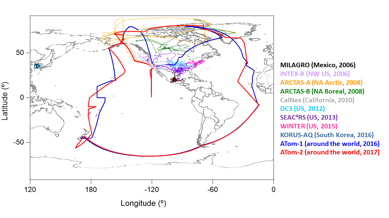
Airborne Observations and Modeling Comparison of Global Inorganic Aerosol Acidity
National Aeronautics and Space Administration —
This dataset provides observations collected during eleven airborne campaigns from 2006–2017 and associated input and output from nine widely used chemical transport...

Official websites use .gov
A
.gov website belongs to an official government
organization in the United States.
Secure .gov websites use HTTPS
A
lock (
) or https:// means you’ve safely connected to
the .gov website. Share sensitive information only on official,
secure websites.